
Greenville, Maine
Greenville, Maine | ||
|---|---|---|
FIPS code 23-29535 | | |
| GNIS feature ID | 0582502 | |
| Website | greenvilleme.com | |
Greenville is a
History
First called T9 R10 NWP (or Township 9, Range 10, North of the
In 1827, Haskell completed a house, and his family joined him. A sawmill was built on Wilson Stream in 1829, with a gristmill added the following year. In 1835, Henry Gower began clearing land beside Moosehead Lake for what would develop into Greenville village. There he erected the first hotel, a two-story building called The Seboomook House, and the first store. On February 6, 1836, Greenville was incorporated from Haskell Plantation, and named for its green forests. By 1846, Greenville village included two houses, two blacksmith shops and a schoolhouse. On August 10, 1848, the town annexed land from Wilson, the remainder of which was distributed to Shirley and Elliotsville.[4]
A small steamboat was launched in 1836 to tow logs, and in 1838 the first large lake steamer began operation. In later years, a succession of steamers by the name of Katahdin plied the waters. The current S/S Katahdin was built in 1914. In July 1884, the Bangor and Piscataquis Railroad (later, the Bangor and Aroostook Railroad) arrived at Greenville Junction. The Canadian Pacific Railway's subsidiary the International Railway of Maine was built through the village in 1888. Tourists were attracted by the region's scenic beauty, hunting and fishing.[5] Consequently, several inns and hotels were built, including the Piscataquis Exchange Hotel, the Squaw Mountain Inn and the Moosehead Inn. Steamboat service was available across Moosehead Lake to the grand Mount Kineo House on a peninsula at Mount Kineo. Today, Greenville remains a popular resort area.[6]
-
 Moosehead Lake from Indian Hill c. 1875
 -
 Moosehead Inn in 1908
 -
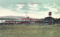 Veneer Products Co. in 1914


Geography
According to the United States Census Bureau, the town has a total area of 46.13 square miles (119.48 km2), of which 42.33 square miles (109.63 km2) is land and 3.80 square miles (9.84 km2) is water.[1] Situated beside Moosehead Lake, Greenville is drained by Wilson Stream.
Located north of the
Climate
This
| Climate data for Greenville, Maine (Greenville Municipal Airport (Maine)), 1991–2020 normals, extremes 1920–present | |||||||||||||
|---|---|---|---|---|---|---|---|---|---|---|---|---|---|
| Month | Jan | Feb | Mar | Apr | May | Jun | Jul | Aug | Sep | Oct | Nov | Dec | Year |
| Record high °F (°C) | 58 (14) |
55 (13) |
76 (24) |
85 (29) |
90 (32) |
95 (35) |
95 (35) |
96 (36) |
92 (33) |
84 (29) |
74 (23) |
59 (15) |
96 (36) |
| Mean maximum °F (°C) | 43.7 (6.5) |
43.5 (6.4) |
53.0 (11.7) |
69.9 (21.1) |
81.8 (27.7) |
85.5 (29.7) |
86.6 (30.3) |
85.6 (29.8) |
81.7 (27.6) |
71.7 (22.1) |
59.7 (15.4) |
48.0 (8.9) |
88.9 (31.6) |
| Mean daily maximum °F (°C) | 22.9 (−5.1) |
25.3 (−3.7) |
34.4 (1.3) |
46.4 (8.0) |
61.5 (16.4) |
70.2 (21.2) |
75.4 (24.1) |
74.1 (23.4) |
66.1 (18.9) |
52.5 (11.4) |
39.3 (4.1) |
28.3 (−2.1) |
49.7 (9.8) |
| Daily mean °F (°C) | 14.2 (−9.9) |
16.3 (−8.7) |
25.6 (−3.6) |
38.0 (3.3) |
51.4 (10.8) |
60.7 (15.9) |
66.3 (19.1) |
64.8 (18.2) |
57.2 (14.0) |
44.9 (7.2) |
32.9 (0.5) |
21.5 (−5.8) |
41.2 (5.1) |
| Mean daily minimum °F (°C) | 5.4 (−14.8) |
7.3 (−13.7) |
16.8 (−8.4) |
29.5 (−1.4) |
41.3 (5.2) |
51.2 (10.7) |
57.2 (14.0) |
55.5 (13.1) |
48.3 (9.1) |
37.3 (2.9) |
26.5 (−3.1) |
14.6 (−9.7) |
32.6 (0.3) |
| Mean minimum °F (°C) | −13.4 (−25.2) |
−10.5 (−23.6) |
−4.5 (−20.3) |
17.6 (−8.0) |
30.3 (−0.9) |
40.2 (4.6) |
48.3 (9.1) |
45.7 (7.6) |
35.2 (1.8) |
25.5 (−3.6) |
11.5 (−11.4) |
−4.1 (−20.1) |
−16.5 (−26.9) |
| Record low °F (°C) | −36 (−38) |
−42 (−41) |
−27 (−33) |
−8 (−22) |
18 (−8) |
24 (−4) |
27 (−3) |
30 (−1) |
20 (−7) |
10 (−12) |
−6 (−21) |
−32 (−36) |
−42 (−41) |
| Average precipitation inches (mm) | 2.98 (76) |
2.41 (61) |
3.19 (81) |
3.59 (91) |
3.59 (91) |
4.04 (103) |
4.01 (102) |
3.96 (101) |
3.44 (87) |
5.00 (127) |
3.96 (101) |
4.33 (110) |
44.50 (1,130) |
| Average snowfall inches (cm) | 24.3 (62) |
24.1 (61) |
20.5 (52) |
10.8 (27) |
0.8 (2.0) |
0.0 (0.0) |
0.0 (0.0) |
0.0 (0.0) |
0.0 (0.0) |
2.5 (6.4) |
11.0 (28) |
21.5 (55) |
115.5 (293.4) |
| Average precipitation days (≥ 0.01 in) | 13.0 | 11.8 | 12.8 | 13.4 | 13.5 | 14.1 | 14.2 | 13.1 | 10.6 | 13.7 | 13.7 | 15.8 | 159.7 |
| Average snowy days (≥ 0.1 in) | 10.8 | 10.1 | 8.9 | 4.7 | 0.5 | 0.0 | 0.0 | 0.0 | 0.0 | 1.0 | 5.4 | 10.0 | 51.4 |
| Source 1: NOAA[8] | |||||||||||||
| Source 2: National Weather Service (snow/snow days 1920–1975)[9] | |||||||||||||
Demographics
| Census | Pop. | Note | %± |
|---|---|---|---|
| 1840 | 128 | — | |
| 1850 | 326 | 154.7% | |
| 1860 | 310 | −4.9% | |
| 1870 | 369 | 19.0% | |
| 1880 | 586 | 58.8% | |
| 1890 | 781 | 33.3% | |
| 1900 | 1,117 | 43.0% | |
| 1910 | 1,474 | 32.0% | |
| 1920 | 1,550 | 5.2% | |
| 1930 | 1,615 | 4.2% | |
| 1940 | 1,955 | 21.1% | |
| 1950 | 1,889 | −3.4% | |
| 1960 | 2,025 | 7.2% | |
| 1970 | 1,894 | −6.5% | |
| 1980 | 1,839 | −2.9% | |
| 1990 | 1,884 | 2.4% | |
| 2000 | 1,623 | −13.9% | |
| 2010 | 1,646 | 1.4% | |
| 2020 | 1,437 | −12.7% | |
| U.S. Decennial Census[10] | |||
2010 census
As of the
There were 820 households, of which 19.4% had children under the age of 18 living with them, 48.4% were married couples living together, 7.0% had a female householder with no husband present, 3.2% had a male householder with no wife present, and 41.5% were non-families. 35.5% of all households were made up of individuals, and 15.3% had someone living alone who was 65 years of age or older. The average household size was 1.98 and the average family size was 2.51.
The median age in the town was 52.3 years. 15.9% of residents were under the age of 18; 4.1% were between the ages of 18 and 24; 18.4% were from 25 to 44; 37.7% were from 45 to 64; and 24.2% were 65 years of age or older. The gender makeup of the town was 48.3% male and 51.7% female.
2000 census
As of the
There were 731 households, out of which 29.5% had children under the age of 18 living with them, 48.6% were married couples living together, 8.1% had a female householder with no husband present, and 40.1% were non-families. 34.9% of all households were made up of individuals, and 20.5% had someone living alone who was 65 years of age or older. The average household size was 2.19 and the average family size was 2.82.
In the town, the population was spread out, with 24.0% under the age of 18, 4.0% from 18 to 24, 25.1% from 25 to 44, 26.7% from 45 to 64, and 20.1% who were 65 years of age or older. The median age was 43 years. For every 100 females, there were 91.6 males. For every 100 females age 18 and over, there were 89.4 males.
The median income for a household in the town was $30,365, and the median income for a family was $36,694. Males had a median income of $27,955 versus $19,712 for females. The
Notes
References
- ^ a b "US Gazetteer files 2010". United States Census Bureau. Retrieved December 16, 2012.
- ^ "Census - Geography Profile: Greenville town, Piscataquis County, Maine". Retrieved January 19, 2022.
- ^ Greenville High School NewsWeek, June 23, 2010
- ^ a b Varney, George J. (1886), Gazetteer of the state of Maine. Greenville, Boston: Russell[permanent dead link]
- ^ Coolidge, Austin J.; John B. Mansfield (1859). A History and Description of New England. Boston, Massachusetts: A.J. Coolidge. pp. 145–146.
coolidge mansfield history description new england 1859.
- ^ History of the Moosehead Lake Region
- ^ Climate Summary for Greenville, Maine
- ^ "U.S. Climate Normals Quick Access – Station: Greenville Maine Forestry SVC, ME". National Oceanic and Atmospheric Administration. Retrieved March 15, 2023.
- ^ "NOAA Online Weather Data – NWS Caribou". National Weather Service. Retrieved March 15, 2023.
- ^ "Census of Population and Housing". Census.gov. Retrieved June 4, 2015.
- ^ "U.S. Census website". United States Census Bureau. Retrieved December 16, 2012.
- ^ "U.S. Census website". United States Census Bureau. Retrieved January 31, 2008.
External links
Municipalities and communities of Piscataquis County, Maine, United States | ||
|---|---|---|
| Towns |  | |
| Plantations | ||
| Unorganized territories | ||
| CDPs | ||
Other villages | ||
| ||
45°27′34″N 69°35′26″W / 45.45944°N 69.59056°W
| International | |
|---|---|
| National | |
| Other | |