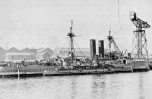
HMCS Canada
 CGS Canada (front) at Barrow-in-Furness in 1904
| |
| History | |
|---|---|
| Name | Canada |
| Builder | Vickers, Sons & Maxim, Barrow-in-Furness |
| Launched | 15 June 1904 |
| Completed | July 1904 |
| Renamed | Queen of Nassau (1924) |
| Fate | Sold for commercial use, sunk 2 July 1926 |
| General characteristics | |
| Type | Patrol vessel |
| Tonnage | 411 GRT |
| Displacement | 557 long tons (566 t) |
| Length |
|
| Beam | 25 ft (7.6 m) |
| Draught | 13 ft (4.0 m) |
| Installed power | 1,800 ihp (1,300 kW) |
| Propulsion | 2 × triple expansion steam engine |
| Speed | 16 knots (30 km/h; 18 mph) |
| Complement | 60 |
| Armament |
|
CGS Canada
Description
Canada was 200 feet (61 m) long as ordered, but ended up 206 ft (63 m) long.
Service history
Civilian service
As part of Prime Minister Sir Wilfrid Laurier's efforts to relieve Great Britain's overall commitment to North American defence in the wake of the Boer War, the Laurier government sought to develop the Fisheries Protection Service. As part of this effort, the government ordered a patrol ship in 1903–1904 for service on the East Coast of Canada.[6][7] Canada was laid down by Vickers, Sons & Maxim at their shipyard in Barrow-in-Furness, England and launched on 15 June 1904. The ship was completed in July that year.[8][9] Canada arrived at Quebec City on 29 September after undergoing a two-week inspection at Gaspé, Quebec. The ship then sailed for Halifax, Nova Scotia to install the Marconi wireless and more sea trials.[9]

In January 1905, with naval militia recruits aboard, the ship was sent to the
In 1908, Canada became a
HMCS Canada

After the
Queen of Nassau
In 1920, Canada was offered for sale at a price of $25,000.
Collier announced some
Wreck site
The wreck was located by technical
Notes
- Canadian Government Ship and HMCS stands for His Majesty's Canadian Ship
- ^ The Miramar Ship Index gives the ship's speed as 16 knots (30 km/h; 18 mph) and Jane's Fighting Ships of World War I claims it was 14 knots.
Citations
- ^ Johnston et al. 2010, p. 211.
- ^ a b c d e Maginley & Collin 2001, p. 89.
- ^ a b c d e f g Macpherson & Barrie 2002, p. 18.
- ^ a b Johnston et al. 2010, p. 139.
- ^ Jane's Fighting Ships of World War I, p. 99.
- ^ Gimblett 2009, p. 4.
- ^ Milner 2010, p. 11.
- ^ a b c Miramar Ship Index.
- ^ a b Johnston et al. 2010, p. 148.
- ^ Johnston et al. 2010, p. 149.
- ^ a b Boswell, Randy (17 April 2010). "Canada's first warship to be preserved – near Florida Keys". Vancouver Sun. Canwest News Service. Archived from the original on 20 April 2010. Retrieved 24 May 2017.
- ^ Johnston et al. 2010, p. 160.
- ^ Johnston et al. 2010, pp. 173–177.
- ^ Johnston et al. 2010, p. 177.
- ^ Johnston et al. 2010, p. 180.
- ^ a b c Casserley, T (2003). "A Ram Bow in the Keys: Latest findings from the Investigation of the Steamer Queen of Nassau". In: SF Norton (Ed). 2003. Diving for Science...2003. Proceedings of the 22nd Annual Scientific Diving Symposium. Greenville, North Carolina: American Academy of Underwater Sciences. Archived from the original on 15 April 2013. Retrieved 31 January 2015.
{{cite journal}}: CS1 maint: unfit URL (link) - ^ Johnston et al. 2010, p. 230.
- ^ Milner 2010, p. 19.
- ^ Tucker 1962, p. 217.
- ^ Johnston et al. 2010, p. 290.
- ^ Hadley & Sarty 1991, p. 121.
- ^ Johnston et al. 2010, p. 615.
- ^ Armstrong 2002, p. 51.
- ^ Johnston et al. 2010, pp. 779, 789.
- ^ a b Barnette, Michael C. "The Queen of Nassau: How one of Canada's first warships ended up off the Florida Keys". Archived from the original on 18 May 2009. Retrieved 31 January 2015.
- ^ Johnston et al. 2010, p. 841.
- ^ a b "National Marine Sanctuaries – Queen of Nassau". National Oceanic & Atmospheric Administration. 1 August 2012. Retrieved 24 May 2017.
- ^ Faulk, Kimberly L. (14 December 2010). "Deepwater Archaeology in Oil and Gas". Museum of Underwater Archaeology.
- ^ "Nautilus Productions – Archaeology". Nautilus Productions.
Bibliography
- Armstrong, John Griffith (2002). The Halifax Explosion and the Royal Canadian Navy: Inquiry and Intrigue. Vancouver: UBC Press. ISBN 0-7748-0891-8.
- "Canada (1116870)". Miramar Ship Index. Retrieved 24 May 2017.
- Gimblett, Richard H., ed. (2009). The Naval Service of Canada 1910–2010: The Centennial Story. Toronto: Dundurn Press. ISBN 978-1-55488-470-4.
- Hadley, Michael L. & Sarty, Roger (1991). Tin-Pots & Pirate Ships: Canadian Naval Forces & German Sea Raiders 1880–1918. Montreal & Kingston: McGill-Queen's University Press. ISBN 0-7735-0778-7.
- Jane's Fighting Ships of World War I. New York: Military Press. 1990 [1919]. ISBN 0-517-03375-5.
- Johnston, William; Rawling, William G.P.; Gimblett, Richard H. & MacFarlane, John (2010). The Seabound Coast: The Official History of the Royal Canadian Navy, 1867–1939. Vol. 1. Toronto: Dundurn Press. ISBN 978-1-55488-908-2.
- Macpherson, Ken & Barrie, Ron (2002). The Ships of Canada's Naval Forces 1910–2002 (Third ed.). St. Catharines, Ontario: Vanwell Publishing. ISBN 1-55125-072-1.
- Maginley, Charles D. & Collin, Bernard (2001). The Ships of Canada's Marine Services. St. Catharines, Ontario: Vanwell Publishing Limited. ISBN 1-55125-070-5.
- Milner, Marc (2010). Canada's Navy: The First Century (Second ed.). Toronto: University of Toronto Press. ISBN 978-0-8020-9604-3.
- Tucker, Gilbert Norman (1962). The Naval Service of Canada, Its Official History – Volume 1: Origins and Early Years. Ottawa, Ontario: King's Printer. OCLC 840569671.
