
Ham-sur-Heure Castle
| Ham-sur-Heure Castle | |
|---|---|
| Wallonia, Belgium | |
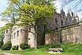
.jpg) Courtyard | |
| Coordinates | 50°19′16″N 4°23′31″E / 50.321°N 4.392°E |
| Type | Castle |
Ham-sur-Heure Castle (
.From 1491 to 1941 it belonged to the
de Mérode family, and from 1941 to 1952 to the descendants of Charles John d'Oultremont
. They sold it to the municipal authorities of Ham-sur-Heure, who used it as their town hall. After the local government reorganisation of 1977 it became the town hall of the present municipality of Ham-sur-Heure-Nalinnes.
-
 Courtyard
 -
 The château from behind
 -
 The château from behind
 -
 The château from across the fields
 -
 South facade
.JPG)
.JPG)
.JPG)

.JPG)
See also
- List of castles in Belgium
- Jean Charles Joseph, Count of Merode, Marquis of Deynze, born and dead in Ham-sur-Heure Castle (1719-1774)
External links
Wikimedia Commons has media related to Castle of Ham-sur-Heure.


.jpg)
This article about a castle or château in Belgium is a stub. You can help Wikipedia by expanding it. |