Henllan
| Henllan | |
|---|---|
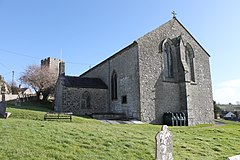
 Church with tower behind | |
Location within Denbighshire | |
| Population | 862 (2011) |
| OS grid reference | SJ022681 |
| Community |
|
| Principal area | |
| Country | Wales |
| Sovereign state | United Kingdom |
| Post town | DENBIGH |
| Postcode district | LL16 |
| Dialling code | 01745 |
| Police | North Wales |
| Fire | North Wales |
| Ambulance | Welsh |
Vale of Clwyd | |
Henllan is a village and
Old Welsh, Hên-llan, meaning "old church-enclosure". The population had increased to 862 at the 2011 census.[1]
The Grade I listed country house, Foxhall Newydd, lies to the southeast. The country house retreat Eriviat Hall also lies outside the village. The Llindir Inn, reputed to be haunted, dates to the 13th century.
Church and bell tower
The tower of Saint Sadwrn's church is unusual in that it was built separate from the main building housing the congregation. The stone tower, which is built on a rising rock, is sited at the highest point in the churchyard. It is thought this was to increase the range over which the tolling bells could be heard by parishioners. The traditional parish of Henllan covered a large area; today it forms part of the Benefice of Henllan, which includes the parishes of Henllan, Bylchau and Gwytherin.[2]
References
- ^ "Community population 2011". Retrieved 22 May 2015.
- ^ Dead link
External links
Wikimedia Commons has media related to Henllan.


