
Llanelidan
This article needs additional citations for verification. (March 2014) |
| Llanelidan | |
|---|---|
 The church from the main road | |
 Llanelidan Location within Denbighshire | |
| Population | 305 (2011) |
| OS grid reference | SJ106504 |
| • Cardiff | 108 mi (174 km) |
| • London | 172 mi (277 km) |
| Community |
|
| Principal area | |
| Country | Wales |
| Sovereign state | United Kingdom |
| Post town | RUTHIN |
| Postcode district | LL15 |
| Dialling code | 01824 |
| Police | North Wales |
| Fire | North Wales |
| Ambulance | Welsh |
Clwyd West | |
Llanelidan is a small village and community in the county of Denbighshire in north-east Wales. The community also includes the hamlet of Rhyd-y-Meudwy.
The church, village hall and pub all lie within 200 yards of each other overlooking the village cricket ground Also in the village centre is King George's field, this is land legally protected by the Fields in Trust Charity, and is free for use by anyone.[1] Public space in the village includes the Village Green. This is 3 1/2 acres of registered Village Green Denbighshire Commons Register No. VG12 Ancient and semi natural woodland that is a bluebell wood in the spring. It was allotted to be held IN TRUST for the Community of Llanelidan by the Inclosure Awards of 1861 and is for the enjoyment and recreation of members of the Parish. It lies north west of the village along a footpath towards Coed Pen Y Bryn. Reference ; Public Record Office MAF 1/243 EXMID 13430 and Map date 1816 found at RRO EXMID 15388 Denbigh Record Office QSD/DE/5
Location

The village of Llanelidan is located just off the A494 road between Ruthin and Corwen in the valley of Afon y Maes, a tributary of the Clwyd. The River Clwyd forms part of the western boundary of the community (parish), which extends further east and south of the village, covering much of the area in the triangle formed by the A-roads joining Ruthin, Corwen and Llandegla. The southernmost tip of the community is marked by Bwrdd y Tri Arglwydd (the table of the three lords), an ancient stone monument marking the point where the lordships of Ruthin, Glyndyfrdwy and Yale met. It is currently the meeting point between the communities of Llanelidan, Bryneglwys, Corwen and Gwyddelwern.
History and amenities
St Elidan Church
Llanelidan is a pretty, scattered hamlet in the green valley of the Afon y Maes, a tributary of the Clwyd. The church - uniquely dedicated to a local saint - stands beside the
Church usually open daylight hours. Further information and opening times from Diocesan Office, High Street, St Asaph, LL17 0RD Phone number: 01745 582245 [3]
-
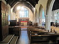 Internal; towards the altar
 -
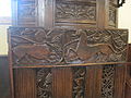 Wood carved pulpit
 -
 Family pews


The village
In December 1873, Major
Llanelidan, the song
A song titled Llanelidan has been written, performed and released to a tune composed by
Notes
As of 28 April 2011, this article is derived in whole or in part from medieval-wales.com/index.php. The copyright holder has licensed the content in a manner that permits reuse under
- ^ "Llanelidan King George V Playing Field". Fields in Trust. Fields in Trust. Retrieved 17 October 2021.
- ^ Dr Charles Kightly. Enjoy Medieval Denbighshire. Denbighshire County Council.
- ^ accessdate=2014-05-31, Diocesan Contacts
- ISBN 0-252-06042-3.
- ISBN 0-520-08316-4.
- ^ Wimbledon's Welsh roots, BBC News, June 30, 2003. Retrieved October 27, 2013.
External links

| International | |
|---|---|
| National | |