Hurricane Erika (2003)
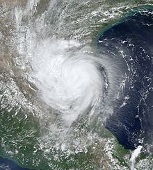
 Erika as a tropical storm after its landfall on Mexico on August 16 | |
| Meteorological history | |
|---|---|
| Formed | August 14, 2003 |
| Post-tropical | August 17, 2003 |
| Dissipated | August 20, 2003 |
| Category 1 hurricane | |
| 1-minute sustained (SSHWS/NWS) | |
| Highest winds | 75 mph (120 km/h) |
| Lowest pressure | 986 mbar (hPa); 29.12 inHg |
| Overall effects | |
| Fatalities | 2 direct |
| Damage | $100,000 (2003 USD) |
| Areas affected | The Bahamas, Florida, Mexico, Southern Texas |
| IBTrACS | |
Part of the 2003 Atlantic hurricane season | |
Hurricane Erika was a weak
While Erika's precursor disturbance was moving across Florida, it dropped heavy rainfall. In south Texas, Erika produced moderate winds of 50 to 60 mph (80 to 97 km/h) along with light rain, causing minor and isolated wind damage in the state. Erika produced moderate rainfall in northeastern Mexico, resulting in mudslides and flooding. There, two people were killed when floodwaters swept away their vehicle.
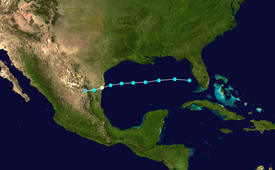
Meteorological history

Tropical storm (39–73 mph, 63–118 km/h)
Category 1 (74–95 mph, 119–153 km/h)
Category 2 (96–110 mph, 154–177 km/h)
Category 3 (111–129 mph, 178–208 km/h)
Category 4 (130–156 mph, 209–251 km/h)
Category 5 (≥157 mph, ≥252 km/h)
Unknown
A weak surface area of low pressure detached from a
A closed low-level circulation nearly developed on August 14 to the east of

With well-established
Operationally, Erika was never upgraded to hurricane status. However, based on a persistent eye feature on radar and
Preparations

The threat of Erika's onslaught prompted the evacuation of 51 oil platforms and 3 oil rigs in the western Gulf of Mexico. The lack of production led to a loss of production of 8,708 barrels (1,384.5 m3) of oil per day and 173.14 million cubic feet (4,903,000 m3) of natural gas per day. On the day of its landfall, the lack of production led to 1,979 less barrels of oil for the day, or about 0.12% of the total daily production for the Gulf of Mexico, while the loss of 32 million cubic feet (910,000 m3) of gas for the day was equivalent to 0.23% of the total production.[4] However, due to its rapid motion, the passage of the storm resulted in minimal effects on operations.[5]
While the storm was located in the eastern Gulf of Mexico on August 15, the
Impact

The precursor disturbance was expected to bring heavy, yet needed rainfall to the
Erika produced light rainfall across southern Texas, peaking at 3.83 inches (97 mm) in
In Mexico, Hurricane Erika primarily affected the states of Tamaulipas and
See also
- Tropical cyclones in 2003
- Other storms named Erika
- List of Texas hurricanes (1980–present)
- List of Category 1 Atlantic hurricanes
- Hurricane Barry (1983) – A Category 1 hurricane that took a similar path
- Hurricane Hanna (2020) – A Category 1 hurricane that took a similar path
References
- ^ a b c d e f g h i j k James L. Franklin (2003). "Hurricane Erika Tropical Cyclone Report" (PDF). National Hurricane Center. Archived (PDF) from the original on September 30, 2015. Retrieved May 22, 2015.
- ^ a b Lixion A. Avila (2003). "Tropical Storm Erika Discussion One". National Hurricane Center. Archived from the original on 2006-04-20. Retrieved 2006-09-24.
- ^ a b Hurricane Erika – August 13–20, 2019. wpc.ncep.noaa.gov (Report). Weather Prediction Center. March 6, 2013. Archived from the original on August 18, 2021. Retrieved August 18, 2021.
- ^ U.S. Department of the Interior (2003). "Tropical Storm Erika Evacuation and Production Statistics". Archived from the original on August 29, 2006. Retrieved 2006-09-24.
- ^ a b c Deborah Tedford (2003). "Tropical Storm Erika Lashes Northern Mexico". Reuters. Archived from the original on 2012-02-05. Retrieved 2006-10-15.
- ^ "Tormenta tropical Erika se debilita en el noreste mexicano" [Tropical Storm Erika weakens in Northeastern Mexico.]. El Universo (in Spanish). El Universo. August 16, 2003. Archived from the original on December 5, 2023. Retrieved December 5, 2023.
{{cite news}}: CS1 maint: others (link) - ^ Lynn Brezosky (2003). "Erika forecast to hit Texas". Associated Press.
- ^ a b c d Desde Dominicana (2003). "17 de agosto de 2003" (in Spanish). Archived from the original on 2014-12-09. Retrieved 2006-09-24.
- ^ Stormcarib.com (2003). "Unofficial Bahamas Reports". Archived from the original on 2013-11-04. Retrieved 2006-09-25.
- ^ Nathan B. Collum (2003). "2003 Hurricane Season Summary" (PDF). Florida Department of Emergency Services. Archived from the original (PDF) on 2006-10-17. Retrieved 2006-09-25.
- ^ Lourdes Briz (2003). "Surfing News from the Space Coast". Florida Today. Archived from the original on July 23, 2004. Retrieved 2006-09-25.
- ^ Roth, David M. (January 3, 2023). "Tropical Cyclone Point Maxima". Tropical Cyclone Rainfall Data. United States Weather Prediction Center. Retrieved January 6, 2023.
 This article incorporates text from this source, which is in the public domain.
- ^ Rob Marciano (2003). "Tropical Storm Erika Misses Texas". CNN. Archived from the original on 2012-02-08. Retrieved 2006-09-25.
- ^ 1634–1699: McCusker, J. J. (1997). How Much Is That in Real Money? A Historical Price Index for Use as a Deflator of Money Values in the Economy of the United States: Addenda et Corrigenda (PDF). American Antiquarian Society. 1700–1799: McCusker, J. J. (1992). How Much Is That in Real Money? A Historical Price Index for Use as a Deflator of Money Values in the Economy of the United States (PDF). American Antiquarian Society. 1800–present: Federal Reserve Bank of Minneapolis. "Consumer Price Index (estimate) 1800–". Retrieved February 29, 2024.
- ^ National Climatic Data Center (2003). "Event Report for Cameron County". Archived from the original on 2016-03-04. Retrieved 2015-05-11.
- ^ a b c Servicio Meteorológico Nacional (2003). "Tormenta Tropical "Erika" del Océano Atlántico" (in Spanish). Archived from the original on July 21, 2006. Retrieved 2006-09-25.
- ^ "Hurricane Erika's Impact on Northeastern Mexico and Texas-Tamaulipas Border". 29 June 2023. Archived from the original on 2023-07-03. Retrieved 2023-07-03.

