
Izawa-no-miya
| Izawa-no-miya 伊雑宮 | |
|---|---|
 Izawa-no-miya
 | |
| Religion | |
| Affiliation | Shinto |
| Deity | Amaterasu |
| Location | |
| Location | Kaminogō, Isobe-cho, Shima-shi, Mie-ken |
 Shown within Mie Prefecture  Izawa-no-miya (Japan) | |
| Geographic coordinates | 34°22′49″N 136°48′32″E / 34.38028°N 136.80889°E |
| Architecture | |
| Style | Shinmei-zukuri |
| Date established | unknown |
Izawa-no-miya (伊雑宮) is a Shinto shrine in the Kaminogō neighborhood of Isobe in the city of Shima in Mie Prefecture, Japan. It is one of the two shrines claiming the title of ichinomiya of former Shima Province. Together with the Takihara-no-miya (瀧原宮) in Taiki, it is one of the Amaterasu-Ōkami no Tonomiya (天照大神の遙宮), or external branches of the Inner Shrine of the Ise Grand Shrine.[1]
Enshrined kami
The kami enshrined at Izawa-no-miya is:
- Amaterashimasusume-Ōkami-no-Mitama (天照坐皇大御神御魂), one of the mitama of the Sun Goddess
History
The origins of the Izawa-no-miya are unknown. According to the spurious
Modern system of ranked Shinto Shrines.[2]
The sacred rice planting ceremony held annually on June 24 is considered to be one of Japan's three major rice planting festivals, along with
Important Intangible Folk Cultural Property in 1990.[3]
The shrine is located a five-minute walk from
Kintetsu Shima Line.[4]
Gallery
-
 Purification spot
 -
 Ablution font
 -
 Torii
Torii -
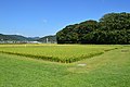 Sacred rice fields
 -
 Rice Planting festival
 -
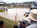 Rice Planting festival


See also
References
- Plutschow, Herbe. Matsuri: The Festivals of Japan. RoutledgeCurzon (1996) ISBN 1-873410-63-8
- Ponsonby-Fane, Richard Arthur Brabazon. (1959). The Imperial House of Japan. Kyoto: Ponsonby Memorial Society. OCLC 194887
External links
Wikimedia Commons has media related to Izawa-no-miya.
- Ise Shime Convention & Tourism official site
- Ise Jingu Official site(in Japanese)
- Prefecture Official tourist information site (in Japanese)
Notes
- ISBN 978-4634150867.
- ISBN 978-4569669304.
- ^ "磯部の御神田" [Isobe no Mikamida] (in Japanese). Agency for Cultural Affairs. Retrieved August 20, 2021.
- ISBN 978-4582945614.
| Authority control databases: National |
|---|