
Jabal Haraz
| Jabal Haraz | |
|---|---|
.jpg) A building with terraces overlooks the side of one of the Haraz Mountains | |
| Highest point | |
| Elevation | 3,000 m (9,800 ft) |
| Coordinates | 15°10′00″N 43°45′00″E / 15.1667°N 43.7500°E |
| Naming | |
| Native name | Jabal Ḥarāz (جَبَل حَرَاز) |
| Geography | |
 Jabal Haraz  Jabal Haraz  Jabal Haraz | |
| Country | |
| Region | South Arabia |
| Official name | Jabal Haraz |
| Criteria | Mixed |
| Designated | 2002 (43rd session) |
| Reference no. | 1722 |
| Region | Arab States |
Jabal Haraz (
History and location
Because of its location between the
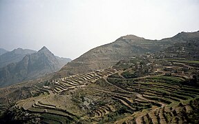
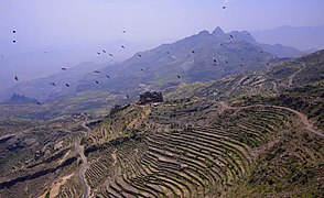
Haraz is as famous for its fortified villages which cling to nearly inaccessible rocky peaks. Their imposing architecture meets two needs: defending the villagers, while leaving plenty of space for crops. Each town is built like a castle; the houses, themselves, form the wall, equipped with one or two easily defensible doors. Constructed from sandstone and basalt, the buildings are integrated into the landscape and it is difficult to tell where the rock and the village begins or ends. The mountain is divided into terraces of a few acres or more, separated by walls sometimes several meters high. On these terraced fields grow alfalfa for livestock, millet, lentils, large areas for coffee and qat. It is one of the main growing areas of Mocha coffee beans.
Within a
]World Heritage Status
This area was added to the
Gallery
-
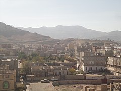
 Manakhah in Sanaa Governorate
 -
 Kawkaban, Al Mahwit Governorate
 -
 Jabal An-Nabi Shu'ayb is behind the mountain in the background, facing west of southern Sanaa City
 -
 Terraces
 -
 Fortified settlement amid the mountains

.jpg)

.jpg)
.jpg)
See also
- Ad Dahrah, located in the Haraz, the stronghold of the Sulaihid dynasty, many of whose buildings still survive to this day
- Geology of Yemen
- Hajhir Mountains
- Middle East
- Near East
References
- ISBN 978-9-4007-5757-8.
- ^ a b "Jabal Haraz". UNESCO World Heritage Centre. 2002-07-08. Retrieved 2009-03-24.
- ISBN 978-1-8416-2212-5.
External links
- Architecture Revived: Architectural Beauty out of Poverty, Jabal Haraz Yemen
- Med-O-Med: Cultural landscapes: Jabal Bura and Jabal Haraz, Yemen
- Jabal Haraz (YouTube)
- Yemen - Haraz Mountains
- Yemen 2008 Jebel Haraz
| World Heritage Sites |
| |||||||||||||
|---|---|---|---|---|---|---|---|---|---|---|---|---|---|---|
| ||||||||||||||
