
Jefferson Peak
| Jefferson Peak | |
|---|---|
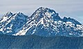
 Mt. Pershing (left) and Jefferson Peak (right) seen from West Seattle | |
| Highest point | |
| Elevation | 5,720 ft (1,743 m)[1] |
| Prominence | 600 ft (183 m)[2] |
| Parent peak | Mount Pershing (6,154 ft)[3] |
| Isolation | 1.30 mi (2.09 km)[3] |
| Coordinates | 47°33′41″N 123°13′55″W / 47.5613874°N 123.2319222°W[4] |
| Naming | |
| Etymology | Thomas Jefferson |
| Geography | |
 Jefferson Peak Location of Jefferson Peak in Washington  Jefferson Peak Jefferson Peak (the United States) | |
| Country | United States |
| State | |
Jefferson Peak is a 5,720-foot (1,743 m) mountain
Topographic relief
is significant as the north aspect rises over 4,100 feet (1,200 m) above the Hamma Hamma valley in approximately one mile.
Climbing
The
class 5.3) subpeak called "Tran Spire" (4,943 feet (1,507 m)) which was first climbed in 1958 by Don Anderson and Robert Petersen .[2][7]
Climate
Jefferson Peak is located in the
marine west coast climate zone of western North America.[8] Weather fronts originating in the Pacific Ocean travel northeast toward the Olympic Mountains. As fronts approach, they are forced upward by the peaks (orographic lift), causing them to drop their moisture in the form of rain or snow. As a result, the Olympics experience high precipitation, especially during the winter months in the form of snowfall.[9] Because of maritime influence, snow tends to be wet and heavy, resulting in avalanche danger. During winter months weather is usually cloudy, but due to high pressure systems over the Pacific Ocean that intensify during summer months, there is often little or no cloud cover during the summer.[9] The months April through August offer the most favorable weather for viewing or climbing this mountain.[2]
Geology
The Olympic Mountains are composed of obducted clastic wedge material and oceanic crust, primarily Eocene sandstone, turbidite, and basaltic oceanic crust.[10] The mountains were sculpted during the Pleistocene era by erosion and glaciers advancing and retreating multiple times.
Gallery
-
 Jefferson Peak centered.
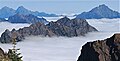
(Mount Bretherton and Mount Constance to left, The Brothers to right) -
 Ferry on Puget Sound. Left to right: Mt. Pershing, Jefferson Peak, Mt. Cruiser, Mt. Skokomish, Mt. Stone
 -
 Left to rightː Mt. Ellinor, Mt. Washington, Mt. Pershing, Jefferson Peak.
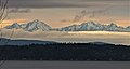
View from Seattle. -
 Jefferson Peak


See also
References
- ISBN 9780898862065, page 65.
- ^ a b c d e f g Jefferson Peak (Thorson Peak), climbersguideolympics.com
- ^ a b "Jefferson Peak - 5,720' WA". listsofjohn.com. Archived from the original on 2022-02-11. Retrieved 2022-02-11.
- ^ a b "Jefferson Peak". Geographic Names Information System. United States Geological Survey, United States Department of the Interior. Retrieved 2022-02-11.
- ISBN 9781565794412, page 48.
- ^ "Jefferson Peak, Washington". Peakbagger.com.
- ^ "Tran Spire, Washington". Peakbagger.com.
- ISSN 1027-5606.
- ^ a b McNulty, Tim (2009). Olympic National Park: A Natural History. Seattle, Washington: University of Washington Press.
- ISBN 0-87842-160-2.
External links
- Weather forecast: Jefferson Peak
- Mount Skokomish Wilderness U.S. Forest Service
Places adjacent to Jefferson Peak | ||||||||||||||||
|---|---|---|---|---|---|---|---|---|---|---|---|---|---|---|---|---|
| ||||||||||||||||