
Kamayama Shrine
This article needs additional citations for verification. (January 2021) |
| Kamayama Shrine | |
|---|---|
竈山神社 | |
 Kamayama Jinja Haiden | |
| Religion | |
| Affiliation | Shinto |
| Deity | Itsuse no Mikoto |
| Festival | October 13. |
| Location | |
| Location | 438 Wada, Wakayama-shi, Wakayama-ken |
 Kamayama Jinja  Kamayama Shrine (Japan) | |
| Geographic coordinates | 34°12′03″N 135°12′17″E / 34.2009°N 135.2046°E |
| Architecture | |
| Style | Kasuga-zukuri |
| Website | |
| Official website | |

Kamayama Shrine (竈山神社, Kamayama jinja) is a Shinto shrine in the city of Wakayama, Wakayama Prefecture, Japan.
History
The main burial mound was built.
As all documentary records of Kameyama Shrine were lost during the
Edo Period, the shrine was under the control of the domain's jisha-bugyō and had no parishioners or outside sources of income.[citation needed
]
Following the
Kanpei Chūsha
) in 1885 and then to Imperial Shrine, 1st rank (官幣大社, Kanpei-taisha) in 1915. It is the only example of a shrine which was promoted from the lowest rank to the highest range in the ranking system. The shrine was extensively remodeled in 1938.
The Kameyama Tomb (竈山墓) is a
circular-type (empun (円墳)) kofun, with a height of one meter and diameter of six meters, located on a hill with an elevation of nine meters. As it has been designated as an imperial tomb by the Imperial Household Agency, archaeological excavation
has been prohibited.
Gallery
-
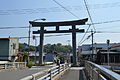 Ō-Torii
 -
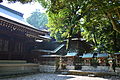 Shaden
 -
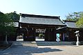 Gate
Gate -
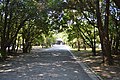 Approach
 -
 Torii
Torii


Transportation
The shrine can be reached by Kamayama Station on the Wakayama Electric Railway Kishigawa Line.[1]
References
- ^ "人の手を借りる、たま駅長 貴志駅(和歌山県、和歌山電鉄貴志川線)" (in Japanese). The Asahi Shimbun. 1 March 2011. Retrieved 15 May 2020.
External links
![]() Media related to Kamayama-jinja at Wikimedia Commons
Media related to Kamayama-jinja at Wikimedia Commons
- Wakayama Jinjacho official website
| International | |
|---|---|
| National | |