
Kesler Peak (Wasatch Range)
| Kesler Peak | |
|---|---|
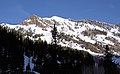
 North aspect | |
| Highest point | |
| Elevation | 10,403 ft (3,171 m)[1][2] |
| Prominence | 443 ft (135 m)[3] |
| Parent peak | Superior Peak (11,132 ft)[4] |
| Isolation | 1.89 mi (3.04 km)[4] |
| Coordinates | 40°37′30″N 111°40′08″W / 40.6250745°N 111.6688679°W[5] |
| Naming | |
| Etymology | Frederick Kesler |
| Geography | |
 Kesler Peak Location in Utah  Kesler Peak Kesler Peak (the United States) | |
| Location | |
Kesler Peak is a 10,403-foot elevation (3,171 m) mountain summit located in Salt Lake County, Utah, United States.
Description
Kesler Peak is set in the
History
The spelling of this mountain's toponym was officially changed in 2008 by the United States Board on Geographic Names.[5] Prior to that it was spelled "Kessler Peak" which appears on older maps, and was also known as "Kessler's Peak" in the early 1900s. This landform is named after Frederick Kesler (1816–1899), Mormon bishop, mill architect, justice of the peace and school warden.[5] There is another Kesler Peak (elevation 8,747 ft) located in the Oquirrh Mountains of Tooele County, Utah, which is also named after this same person.[7]
Kesler Peak is centrally located in the Big Cottonwood Mining District. From 1867 to 1976, the Big Cottonwood and Little Cottonwood mining districts combined to produce 30,600 ounces of gold, 17.5 million ounces of silver, 4.7 million pounds of zinc, 18.1 million pounds of copper, and 252 million pounds of lead. The Carbonate Mine, situated high on the east slope of Kesler Peak, was a major producer.[8]
Gallery
-
 Southeast aspect
 -
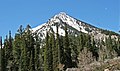 Kesler Peak seen from the trailhead to Doughnut Falls
 -
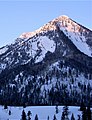
 South aspect
 -
-
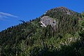 Northeast slope of Kesler Peak


See also
References
- ^ United States Geological Survey topographical map - Mount Aire
- ^ ISBN 9781460284131
- ^ "Kessler Peak, Utah". Peakbagger.com. Retrieved 2022-08-14.
- ^ a b c "Kessler Peak - 10,403' UT". listsofjohn.com. Retrieved 2022-08-14.
- ^ a b c "Kesler Peak". Geographic Names Information System. United States Geological Survey, United States Department of the Interior. Retrieved 2022-08-14.
- ^ Francis C. Nicholas (1907), The Re-Opening of the Carbonate Mine, Utah, Mining and Engineering World, Volume 26, p. 9
- ^ "Kesler Peak". Geographic Names Information System. United States Geological Survey, United States Department of the Interior. Retrieved 2022-08-14.
- ISBN 9781557917263, p. 22
External links
- Kesler Peak: weather forecast