
Kfar Sirkin
Kfar Sirkin
כְּפַר סִירְקִין | |
|---|---|
 | |
 Kfar Sirkin | |
| Coordinates: 32°4′36″N 34°55′25″E / 32.07667°N 34.92361°E | |
| Country | Israel |
| District | Central |
| Council | Southern Sharon |
| Founded | 1933 |
| Population (2022)[1] | 1,519 |
| Website | http://www.kfarsirkin.org.il/ |
Kfar Sirkin or Kefar Syrkin (Hebrew: כְּפַר סִירְקִין) is a moshav in central Israel. Located south-east of Petah Tikva, it falls under the jurisdiction of Drom HaSharon Regional Council. In 2022 it had a population of 1,519.[1]
History
Kfar Sirkin was founded in 1933 and was named for the
Arab forces and to store weapons which were illegal under the British Mandate
rule of the time.
Today, the village is agricultural. An Israel Defense Forces military base, and former RAF airfield, is located to the north-west of the village.
Gallery
-
 Local synagogue
 -
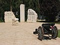 Memorial to residents who fell in the line of duty
 -
 Water tower
 -
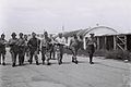 Kfar Sirkin base 16 June 1948


.jpg)
References
- ^ a b "Regional Statistics". Israel Central Bureau of Statistics. Retrieved 21 March 2024.
External links
| International | |
|---|---|
| National | |
This geography of Israel article is a stub. You can help Wikipedia by expanding it. |