
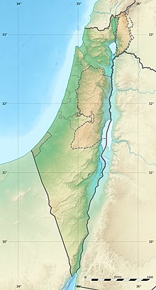
Geography of Israel
 | |
| Continent | Asia |
|---|---|
| Region | Levant |
| Coordinates | 31°N 35°E / 31°N 35°E |
| Area | Ranked 150th |
| • Total | 20,770[1][2] km2 (8,020 sq mi) |
| • Land | 97.88% |
| • Water | 2.12% |
| Coastline | 273[1] km (170 mi) |
| Borders | |
| Highest point | Mount Meron |
| Lowest point | Dead Sea |
| Longest river | Jordan River |
| Largest lake | Sea of Galilee |
| Climate | Mediterranean |
| Natural resources | Offshore gas fields, Dead Sea minerals (potash, magnesium) |
| Exclusive economic zone | 26,352 km2 (10,175 sq mi) |
The geography of Israel is very diverse, with desert conditions in the south, and snow-capped mountains in the north. Israel is located at the eastern end of the Mediterranean Sea in West Asia.[1] It is bounded to the north by Lebanon, the northeast by Syria, the east by Jordan and the West Bank, and to the southwest by Egypt.[1] To the west of Israel is the Mediterranean Sea, which makes up the majority of Israel's 273 km (170 mi) coastline,[3] and the Gaza Strip. Israel has a small coastline on the Red Sea in the south.
Israel's area is approximately 20,770 km2 (8,019 sq mi), which includes 445 km2 (172 sq mi) of inland water.
The Israeli-occupied territories include the West Bank, 5,879 km2 (2,270 sq mi), East Jerusalem, 70 km2 (27 sq mi) and the Golan Heights, 1,150 km2 (444 sq mi).[2] Geographical features in these territories will be noted as such. Of these areas, Israel has annexed East Jerusalem and the Golan Heights, an act not recognized by the international community.
Southern Israel is dominated by the
Location and boundaries

Israel lies to the north of the equator around 31°30' north latitude and 34°45' east longitude.
Prior to the establishment of the
Modern Israel is bounded to the north by Lebanon, the northeast by Syria, the east by Jordan and the West Bank, and to the southwest by Egypt. To the west of Israel is the Mediterranean Sea, which makes up the majority of Israel's 273 km (170 mi) coastline and the Gaza Strip. Israel has a small coastline on the Red Sea in the south. The southernmost settlement in Israel is the city of Eilat whilst the northernmost is the town of Metula. The territorial waters of Israel extend into the sea to a distance of twelve nautical miles measured from the appropriate baseline.[1]
The statistics provided by the
| Name | Status Description | Population (thousands) | Area (km2) | ||||
|---|---|---|---|---|---|---|---|
Israeli settlers in the Israeli-occupied territories )
|
Cumulative Total | Palestinians (incl. non-Israeli Palestinians residing legally in Israel )
|
Cumulative Total | Area | Cumulative Total | ||
| Israel (Green Line) | Area sovereign to Israel since 1948 | 6,674[7] | 6,674[7] | 100–120[8] | 100–120[8] | 20,582[7] | 20,582[7] |
| East Jerusalem | Occupied and subject to Israeli law since 1967. Formal legislation on 1980 (see Jerusalem Law) | 455[9] | 7,129[7] | 225 (double counted)[10] | 225[7] | 336[11] | 20,918[7] |
| Golan Heights | Occupied since 1967, subject to Israeli law since 1981 (see Golan Heights Law) | 42[12] | 7,172[12] | n.a. | n.a. (Syrians) | 1,154[13] | 22,072[13] |
| Seam Zone (West Bank) | Area between the Green Line and the Israeli West Bank barrier. Occupied in 1967 | 188[14] | 7,359[7] | 35[14] | 260[7] | 200[11] | 22,272[7] |
| Other Israeli settlements and IDF Military Areas (West Bank Area C) | Other Israeli settlements (not in East Jerusalem or the Seam Zone) and areas in the West Bank directly controlled by the IDF. Occupied in 1967 | 57[7] | 7,473[12] | 115[15] | 375[7] | 2,961[16] | 25,233[7] |
| Palestinian civil control (West Bank Areas A+B) | Palestinian National Authority civil controlled area. Subject to "joint" military control with the IDF. Occupied in 1967 | 0 | 7,473[7] | 2,311[17] | 2,686[7] | 2,143[15] | 27,376[7] |
| Gaza Strip | unilaterally disengaged in 2005, declared a foreign entity in 2007.
|
0 | 7,473[7] | 1,552[18] | 4,238[7] | 360[18] | 27,736[7] |
Physiographic regions
Valley
of Eilat
Israel is divided into four physiographic regions: the
Coastal plain
The Israeli Coastal Plain stretches from the Lebanese border in the north to
Geographically, the region is divided into five sub-regions. The northernmost section lays between the Lebanese border, the
Central hills

Inland (east) of the coastal plain lies the central
Jordan Rift Valley

East of the central highlands lies the
Negev Desert

The
Unique to the Negev region are the craterlike
Geology
.jpg)
Israel is divided east–west by a mountain range running north to south along the coast. Jerusalem sits on the top of this ridge, east of which lies the Dead Sea graben which is a pull-apart basin on the Dead Sea Transform fault.[25]
The numerous
The far northern coastline of the country has some chalk landscapes best seen at Rosh HaNikra, a chalk cliff into which a series of grottoes have been eroded.[26]
Seismic activity
The Jordan Rift Valley is the result of tectonic movements within the Dead Sea Transform (DSF) fault system. The DSF forms the transform boundary between the African Plate to the west and the Arabian Plate to the east. The Golan Heights and all of Jordan are part of the Arabian Plate, while the Galilee, West Bank, Coastal Plain, and Negev along with the Sinai Peninsula are on the African Plate. This tectonic disposition leads to a relatively high seismic activity in the region.
The entire Jordan Valley segment is thought to have ruptured repeatedly, for instance during the last two major earthquakes along this structure in 749 and 1033. The deficit in slip that has built up since the 1033 event is sufficient to cause an earthquake of Mw ~7.4.[27]
The most catastrophic earthquakes occurred in 31 BCE, 363, 749, and 1033 CE, that is every ca. 400 years on average.[28] Destructive earthquakes leading to serious loss of life strike about every 80 years.[29] While stringent construction regulations are currently in place and recently built structures are earthquake-safe, as of 2007 the majority of the buildings in Israel were older than these regulations and many public buildings as well as 50,000 residential buildings did not meet the new standards and were "expected to collapse" if exposed to a strong quake.[29] Given the fragile political situation of the Middle East region and the presence there of major holy sites, a quake reaching magnitude 7 on the Richter scale could have dire consequences for world peace.[28]
Rivers and lakes
.svg)
Israel's longest and most famous river is the 320-kilometre (199 mi) long

The Sea of Galilee (also called the Kinneret) is Israel's largest and most important
South of the Kinneret lies the saltwater Dead Sea which forms the border between Israel and Jordan and is 418 meters (1,371 ft) below sea level, making it the lowest water surface on Earth.[32] The Dead Sea is 67 kilometers (42 mi) long with a maximum width of 16 kilometers (10 mi) and also makes up part of the Rift Valley.[32] A peninsula juts out into the lake from the eastern shore, south of which the lake is shallow, less than 6 meters (19.7 ft) deep. To the north is the lake's greatest depth.[32]
There are no navigable, artificial waterways in Israel, although the
Selected elevations

The following are selected elevations of notable locations, from highest to lowest:[34]
| Location | Region | Elevation (feet) | Elevation (meters) |
|---|---|---|---|
| Mount Hermon | Golan Heights (Israeli-occupied) | 7,336 ft. | 2,236 m. |
| Mount Meron | Upper Galilee | 3,964 ft. | 1,208 m. |
| Mount Ramon | Negev | 3,396 ft. | 1,035 m. |
| Mount of Olives | East Jerusalem (Israeli-occupied) | 2,739 ft. | 835 m. |
| Mount Tabor | Lower Galilee | 1,930 ft. | 588 m. |
| Mount Carmel | Haifa | 1,792 ft. | 546 m. |
| Dead Sea | Judean Desert | – 1,368 ft. | – 417 m. |
Climate


The northern half of Israel, has a
On average, January is the coldest month with average temperatures ranging from 6 to 15 °C (42.8 to 59.0 °F), and July and August are the hottest months at 22 to 33 °C (71.6 to 91.4 °F), on average across the country.[35] Summers are very humid along the Mediterranean coast but dry in the central highlands, the Rift Valley, and the Negev Desert. In Eilat, a desert city, summer daytime-temperatures are often the highest in the state, at times reaching 44 to 46 °C (111.2 to 114.8 °F). More than 70% of the average rainfall in Israel falls between November and March; June through September are usually rainless.[35] Rainfall is unevenly distributed, significantly lower in the south of the country.[35] In the extreme south, rainfall averages near 30 millimeters (1.18 in) annually; in the north, average annual rainfall exceeds 900 millimeters (35.4 in).[35] Rainfall varies from season to season and from year to year, particularly in the Negev Desert. Precipitation is often concentrated in violent storms, causing erosion and flash floods.[35] In winter, precipitation often takes the form of snow at the higher elevations of the central highlands, including Jerusalem.[35] Mount Hermon has seasonal snow which covers all three of its peaks in winter and spring. In rare occasions, snow gets to the northern mountain peaks and only in extremely rare occasions even to the coast. The areas of the country most cultivated are those receiving more than 300 millimeters (11.8 in) of rainfall annually, making approximately one-third of the country cultivable.[35]
Thunderstorms and hail are common throughout the rainy season and waterspouts occasionally hit the Mediterranean coast, capable of causing only minor damage. However,
Heat waves are frequent. 2010 was the hottest year in the history of Israel with absolute record high in several places in August. The heat became stronger from August when temperatures were considerably above the average. October and November were also dry, and November was almost rainless when it was supposed to be rainy.
Climate charts of different locations in Israel
| Tel Aviv | ||||||||||||||||||||||||||||||||||||||||||||||||||||||||||||
|---|---|---|---|---|---|---|---|---|---|---|---|---|---|---|---|---|---|---|---|---|---|---|---|---|---|---|---|---|---|---|---|---|---|---|---|---|---|---|---|---|---|---|---|---|---|---|---|---|---|---|---|---|---|---|---|---|---|---|---|---|
| Climate chart (explanation) | ||||||||||||||||||||||||||||||||||||||||||||||||||||||||||||
| ||||||||||||||||||||||||||||||||||||||||||||||||||||||||||||
| ||||||||||||||||||||||||||||||||||||||||||||||||||||||||||||
| Beit Dagan | ||||||||||||||||||||||||||||||||||||||||||||||||||||||||||||
|---|---|---|---|---|---|---|---|---|---|---|---|---|---|---|---|---|---|---|---|---|---|---|---|---|---|---|---|---|---|---|---|---|---|---|---|---|---|---|---|---|---|---|---|---|---|---|---|---|---|---|---|---|---|---|---|---|---|---|---|---|
| Climate chart (explanation) | ||||||||||||||||||||||||||||||||||||||||||||||||||||||||||||
| ||||||||||||||||||||||||||||||||||||||||||||||||||||||||||||
| ||||||||||||||||||||||||||||||||||||||||||||||||||||||||||||
| Jerusalem | ||||||||||||||||||||||||||||||||||||||||||||||||||||||||||||
|---|---|---|---|---|---|---|---|---|---|---|---|---|---|---|---|---|---|---|---|---|---|---|---|---|---|---|---|---|---|---|---|---|---|---|---|---|---|---|---|---|---|---|---|---|---|---|---|---|---|---|---|---|---|---|---|---|---|---|---|---|
| Climate chart (explanation) | ||||||||||||||||||||||||||||||||||||||||||||||||||||||||||||
| ||||||||||||||||||||||||||||||||||||||||||||||||||||||||||||
| ||||||||||||||||||||||||||||||||||||||||||||||||||||||||||||
| Haifa | ||||||||||||||||||||||||||||||||||||||||||||||||||||||||||||
|---|---|---|---|---|---|---|---|---|---|---|---|---|---|---|---|---|---|---|---|---|---|---|---|---|---|---|---|---|---|---|---|---|---|---|---|---|---|---|---|---|---|---|---|---|---|---|---|---|---|---|---|---|---|---|---|---|---|---|---|---|
| Climate chart (explanation) | ||||||||||||||||||||||||||||||||||||||||||||||||||||||||||||
| ||||||||||||||||||||||||||||||||||||||||||||||||||||||||||||
| ||||||||||||||||||||||||||||||||||||||||||||||||||||||||||||
| Safed | ||||||||||||||||||||||||||||||||||||||||||||||||||||||||||||
|---|---|---|---|---|---|---|---|---|---|---|---|---|---|---|---|---|---|---|---|---|---|---|---|---|---|---|---|---|---|---|---|---|---|---|---|---|---|---|---|---|---|---|---|---|---|---|---|---|---|---|---|---|---|---|---|---|---|---|---|---|
| Climate chart (explanation) | ||||||||||||||||||||||||||||||||||||||||||||||||||||||||||||
| ||||||||||||||||||||||||||||||||||||||||||||||||||||||||||||
| ||||||||||||||||||||||||||||||||||||||||||||||||||||||||||||
| Beersheba | ||||||||||||||||||||||||||||||||||||||||||||||||||||||||||||
|---|---|---|---|---|---|---|---|---|---|---|---|---|---|---|---|---|---|---|---|---|---|---|---|---|---|---|---|---|---|---|---|---|---|---|---|---|---|---|---|---|---|---|---|---|---|---|---|---|---|---|---|---|---|---|---|---|---|---|---|---|
| Climate chart (explanation) | ||||||||||||||||||||||||||||||||||||||||||||||||||||||||||||
| ||||||||||||||||||||||||||||||||||||||||||||||||||||||||||||
| ||||||||||||||||||||||||||||||||||||||||||||||||||||||||||||
| Tiberias | ||||||||||||||||||||||||||||||||||||||||||||||||||||||||||||
|---|---|---|---|---|---|---|---|---|---|---|---|---|---|---|---|---|---|---|---|---|---|---|---|---|---|---|---|---|---|---|---|---|---|---|---|---|---|---|---|---|---|---|---|---|---|---|---|---|---|---|---|---|---|---|---|---|---|---|---|---|
| Climate chart (explanation) | ||||||||||||||||||||||||||||||||||||||||||||||||||||||||||||
| ||||||||||||||||||||||||||||||||||||||||||||||||||||||||||||
| ||||||||||||||||||||||||||||||||||||||||||||||||||||||||||||
| Eilat | ||||||||||||||||||||||||||||||||||||||||||||||||||||||||||||
|---|---|---|---|---|---|---|---|---|---|---|---|---|---|---|---|---|---|---|---|---|---|---|---|---|---|---|---|---|---|---|---|---|---|---|---|---|---|---|---|---|---|---|---|---|---|---|---|---|---|---|---|---|---|---|---|---|---|---|---|---|
| Climate chart (explanation) | ||||||||||||||||||||||||||||||||||||||||||||||||||||||||||||
| ||||||||||||||||||||||||||||||||||||||||||||||||||||||||||||
| ||||||||||||||||||||||||||||||||||||||||||||||||||||||||||||
Natural resources
Unlike much of the Middle East which is rich in lucrative
Environmental concerns


Israel has a large number of environmental concerns ranging from natural hazards to man-made issues both resulting from ancient times to modern development. Natural hazards facing the country include
- Convention on Biological Diversity
- UNFCCC– Climate Change
- United Nations Convention to Combat Desertification
- Convention on the International Trade in Endangered Species of Wild Flora and Fauna
- Hazardous Wastes
- Nuclear Test Ban
- Montreal Protocol – Ozone Layer Protection
- MARPOL 73/78 – Ship Pollution
- Convention on Wetlands of International Importance Especially As Waterfowl Habitat
Signed but not ratified:
- Kyoto Protocol
- Marine Life Conservation
Rural settlements
Israel's rural space includes several unique kinds of settlements, notably the moshav and the kibbutz.[38] Originally these were collective and cooperative settlements respectively.[38] Over time, the degree of cooperation in these settlements has decreased and in several of them the cooperative structure has been dismantled altogether.[38] All rural settlements and many small towns (some of which are dubbed "rurban settlements") are incorporated in regional councils. Land use in Israel is 17% arable land, 4% permanent crops, and 79% other uses.[1] As of 2003 1,940 square kilometers (749 sq mi) were irrigated.[1]
There are 242 Israeli settlements and civilian land use sites in the West Bank, 42 in the Golan Heights, and 29 in East Jerusalem.[1]
Islands
Israel has the
Human geography
| Rank | Name | District | Pop. | Rank | Name | District | Pop. | ||
|---|---|---|---|---|---|---|---|---|---|
 Jerusalem  Tel Aviv |
1 | Jerusalem | Jerusalem | 981,711a | 11 | Ramat Gan | Tel Aviv | 172,486 |  Haifa  Rishon LeZion |
| 2 | Tel Aviv | Tel Aviv | 474,530 | 12 | Ashkelon | Southern | 153,138 | ||
| 3 | Haifa | Haifa | 290,306 | 13 | Rehovot | Central | 150,748 | ||
| 4 | Rishon LeZion | Central | 260,453 | 14 | Beit Shemesh | Jerusalem | 154,694 | ||
| 5 | Petah Tikva | Central | 255,387 | 15 | Bat Yam | Tel Aviv | 128,465 | ||
| 6 | Ashdod | Southern | 226,827 | 16 | Herzliya | Tel Aviv | 106,741 | ||
| 7 | Netanya | Central | 233,104 | 17 | Kfar Saba | Central | 101,556 | ||
| 8 | Bnei Brak | Tel Aviv | 218,357 | 18 | Hadera | Haifa | 103,041 | ||
| 9 | Beersheba | Southern | 214,162 | 19 | Modi'in-Maccabim-Re'ut | Central | 99,171 | ||
| 10 | Holon | Tel Aviv | 197,957 | 20 | Lod | Central | 85,351 | ||
^a This number includes East Jerusalem and West Bank areas, which had a total population of 573,330 inhabitants in 2019.[42] Israeli sovereignty over East Jerusalem is internationally unrecognized.

As of 2013, the population of Israel is 8 million, 6,015,000 of them Jewish.[43]
For statistical purposes, the country has three
Israel's population is diverse demographically; 76% Jewish, 20%
Overshoot index
Israel is ranked
See also
- Archaeology of Israel
- Kurkar
- Land of Israel
- List of endemic flora of Israel
- Historical maps of Israel
- National parks and nature reserves of Israel
- Outline of Israel
- Tourism in Israel
- Wildlife of Israel
References
- ^ a b c d e f g h i j k l m n o p q r s t u v w x y z aa ab "Israel". CIA World Factbook. Retrieved 8 April 2008.
- ^ ISBN 978-1-4191-2689-5.
- ^ a b c "Israel – Geography". U.S. Library of Congress. Retrieved 8 April 2008.
- ^ An Empire in the Holy Land: Historical Geography of the British Administration in Palestine, 1917–1929, Gideon Biger, St. Martin's Press and Magnes Press, 1994, pp.40–41.
- ^ An Empire in the Holy Land: Historical Geography of the British Administration in Palestine, 1917–1929, Gideon Biger, St. Martin's Press and Magnes Press, 1994, pp.46–52.
- ^ An Empire in the Holy Land: Historical Geography of the British Administration in Palestine, 1917–1929, Gideon Biger, St. Martin's Press and Magnes Press, 1994, pp.67–69.
- ^ a b c d e f g h i j k l m n o p q r s Figure calculated from other sourced figures in table
- ^ a b "MIFTAH - Family Reunification".
- Jerusalem Institute for Israel Studies. "Jerusalem Statistical Yearbook 2009/10" (PDF). Archived from the original(PDF) on 12 March 2011. Retrieved 5 October 2010.
- ^ Middle East Forum (March 2009). "The Politics of Palestinian Demography". Middle East Quarterly. Retrieved 5 October 2010.
- ^ Office for the Coordination of Humanitarian Affairs. "Barrier Report July 2009. Calculation based on East Jerusalem area of 346km2 being 97% west of the barrier, and 9.5% of the West bank including East Jerusalem being in the Seam Zone" (PDF). Archived from the original(PDF) on 13 October 2009. Retrieved 5 October 2010.
- ^ a b c Israel Central Bureau of Statistics. "Israeli Census data" (PDF). Archived from the original (PDF) on 29 December 2009. Retrieved 5 October 2010.
- ^ a b Israel Central Bureau of Statistics. "Israeli statistical Area data" (PDF). Retrieved 5 October 2010.
- ^ a b B'Tselem. "Separation Barrier Statistics". Archived from the original on 20 November 2003. Retrieved 5 October 2010.
- ^ Office for the Coordination of Humanitarian Affairs. "Area C Humanitarian Response Plan Fact Sheet September 2010. Assumes 35,000 Palestinians estimated by B'Tselem to be living in the Seam Zone are included in the 150,000 OCHA estimate" (PDF). Archived from the original(PDF) on 11 October 2010. Retrieved 5 October 2010.
- ^ CIA World Factbook. "West Bank population. Based on total area of 5,640km2 including East Jerusalem and excluding water. Figure shown calculated from other figures sourced on page". Retrieved 5 October 2010.
- ^ CIA World Factbook. "West Bank population. Assumes CIA World Factbook number excludes Israeli settlers but includes estimated 225k Palestinians living in East Jerusalem". Retrieved 5 October 2010.
- ^ a b CIA World Factbook. "Gaza Strip population. Excludes Israeli settlers, but includes estimated 225k Non-Israeli Palestinians in East Jerusalem". Retrieved 5 October 2010.
- ^ a b c d e f g h i j k l m n o p q r s "Israel Topography". U.S. Library of Congress. Retrieved 8 April 2008.
- ^ "River Restoration". Israel Ministry of the Environment. Retrieved 29 July 2011.
- ^ a b "The coastal plain". Archived from the original on 6 September 2011. Retrieved 26 January 2008.
- ^ "Makhteshim Country". UNESCO. Retrieved 8 April 2008.
- ^ a b c d e f g "Israel's Negev Desert". Archived from the original on 22 February 2008. Retrieved 8 April 2008.
- ^ "Israel Natural Environment". Geckogo.com. Archived from the original on 1 September 2009.
- ^ a b c "Geology of Israel". Retrieved 8 April 2008.
- ^ "Rosh HaNikra". JAFI. Archived from the original on 17 May 2008. Retrieved 8 April 2008.
- .
- ^ a b American Friends of the Tel Aviv University, Earthquake Experts at Tel Aviv University Turn to History for Guidance (4 October 2007). Quote: The major ones were recorded along the Jordan Valley in the years 31 B.C.E., 363 C.E., 749 C.E., and 1033 C.E. "So roughly, we are talking about an interval of every 400 years. If we follow the patterns of nature, a major quake should be expected any time because almost a whole millennium has passed since the last strong earthquake of 1033." (Tel Aviv University Associate Professor Dr. Shmuel (Shmulik) Marco). [1] Archived 6 October 2016 at the Wayback Machine
- ^ a b Zafrir Renat, Israel Is Due, and Ill Prepared, for Major Earthquake, Haaretz, 15 January 2010. "On average, a destructive earthquake takes place in Israel once every 80 years, causing serious casualties and damage." [2]
- ^ a b c d "River Jordan". Encarta. Archived from the original on 15 May 2009. Retrieved 9 September 2010.
- ^ "Lake Tiberias". Encarta. Archived from the original on 12 October 2008. Retrieved 8 April 2008.
- ^ a b c "Dead Sea". Archived from the original on 6 October 2008. Retrieved 8 April 2008.
- ^ "Dead Sea Canal". Archived from the original on 27 March 2009. Retrieved 8 April 2008.
- ^ Statistical Abstract of Israel, No. 58, 2007
- ^ a b c d e f g h i j k "Climate". U.S. Library of Congress. Retrieved 8 April 2008.
- ^ "'Mini-tornado' sweeps through western Galilee". Ynet. Retrieved 8 April 2008.
- ^ Bar, Avi (18 January 2009). "Israel's largest-ever reserve of natural gas discovered off Haifa coast". Haaretz.
- ^ a b c "Rural Settlement Geography of Israel" (PDF). Indiana State University. Archived from the original (PDF) on 7 April 2008. Retrieved 7 April 2008.
- ^ Frenkel, Billie (20 June 1995). "Israel considers building artificial islands – Israel Environment". Ynetnews. Ynet.
- ^ Ben, Ilan (17 June 2012). "Short on space, Israel looks to artificial islands". The Times of Israel.
- ^ "Regional Statistics". Israel Central Bureau of Statistics. Retrieved 21 March 2024.
- ^ Choshen, Maya (2021). "Population of Jerusalem, by Age, Religion and Geographical Spreading, 2019" (PDF). Jerusalem Institute for Policy Research. Retrieved 19 May 2021.
- ^ Druckman, Yaron (30 December 2012). "CBS: Israel home to 8 Million citizens". Ynetnews. Ynet.
- ^ "Localities, Population, and Density" (PDF). Archived from the original (PDF) on 8 February 2012. Retrieved 2 July 2007.
- ^ "Jerusalem: From Town to Metropolis". University of Southern Maine. Archived from the original on 7 March 2008. Retrieved 8 April 2008.
- ^ "Initiated Development in the Nazareth Region". Archived from the original on 12 November 2007. Retrieved 8 April 2008.
- ^ a b Mahler, Gregory S. Politics and Government in Israel: The Maturation of a Modern State. Rowman & Littlefield. p. 229.
- ^ Troen, Selwyn Ilan; Noah Lucas. Israel: The First Decade of Independence. SUNY Press. p. 496.
- ^ Herzog, Hanna. Gendering Politics: Women in Israel. University of Michigan Press. p. 22.
- ^ "Population by population group". Israel CBS. Retrieved 8 April 2008.
- ^ "Population by religion". Israel CBS. Retrieved 8 April 2008.
- ^ "Social Survey" (in Hebrew). Israel CBS. 2006. Archived from the original on 7 April 2008. Retrieved 8 April 2008.
- ^ "Circassians in Israel". Archived from the original on 14 March 2008. Retrieved 8 April 2008.
- ^ "Overshoot Index 2011" (PDF). Population Matters. Archived from the original (PDF) on 20 July 2013. Retrieved 19 August 2014.
External links
 Wikimedia Atlas of Israel
 Geographic data related to Israel at OpenStreetMap
- Geography and Climate at the Israel Ministry of Foreign Affairs website
- Geography and Nature at the Israel Ministry of Tourism website
- Israel: Maps and Views at Curlie
| Districts |  | ||||||||
|---|---|---|---|---|---|---|---|---|---|
| Bodies of water |
| ||||||||
| Cities | |||||||||
| Regions |
| ||||||||
| Islands | |||||||||
| Bordering nations | |||||||||
| Archaeology |
| ||||||||