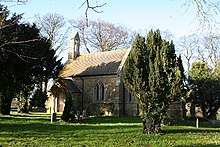
Kirmond le Mire
Appearance
| Kirmond le Mire | ||
|---|---|---|
Shire county | ||
| Region | ||
| Country | England | |
| Sovereign state | United Kingdom | |
| Post town | Market Rasen | |
| Postcode district | LN8 | |
| Police | Lincolnshire | |
| Fire | Lincolnshire | |
| Ambulance | East Midlands | |
| UK Parliament | ||
Kirmond le Mire is a small village and
B1203 road, 6 miles (10 km) east from Market Rasen and 11 miles (18 km) south-west from Grimsby. It is in the civil parish of Thoresway
.

Kirmond le Mire
The parish includes the lost Medieval settlement of Beckfield.[2]
The village's name dates to at least 1086, soon after the
Norman conquest of England.[3]
It is seen in the earliest historical documents as Chevremont-le-myrr, and in some later documents as Kevermond.
References
- ^ Historic England. "Church of St Martin, Kirmond Le Mire (1359767)". National Heritage List for England. Retrieved 21 April 2012.
- ^ Historic England. "Beckfield (351848)". Research records (formerly PastScape). Retrieved 21 April 2012.
- ISBN 9780199609086. p. 280.
External links
 Media related to Kirmond le Mire at Wikimedia Commons
- "Kirmond le Mire", Genuki.org.uk. Retrieved 21 April 2012
