
Korab
| Korab | |
|---|---|
Mount Korab | |
| Elevation | 2,764 m (9,068 ft) |
| Prominence | 2,169 m (7,116 ft) |
| Coordinates | 41°47′25″N 20°32′48″E / 41.79028°N 20.54667°E |
| Geography | |
 Korab Location on the Balkan peninsula | |
| Countries | Albania and North Macedonia |
| Geology | |
| Age of rock | Paleozoic |
| Mountain type | Range |
| Type of rock | Limestone |
Korab (
sea god
.
Dibër Valley in a north-south direction, between the river valleys of the Black Drin and its tributary the Radika. It is located near the tripoint of Albania, North Macedonia, and Kosovo, southwest of the Šar Mountains
. The Drin Valley lies around 400 m (1,300 ft) to the west, the bed of the Radika at about 1,000 m (3,300 ft) above sea level.
The geology of the park is dominated by mountains made up of exposed faulted sedimentary rock and valleys containing glacial lakes.
The Albanian part has numerous high peaks and ranges, almost as tall as the Korab
Mali i Gramës 2,345 m (7,694 ft). The mountains are composed of shale and limestone. Much of the range is protected by nature parks, a prominent one being the Korab-Koritnik Nature Park.[3][4]
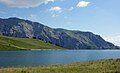
South of the complex of peaks around Mount Korab, there are other large mountains:
Dešat's Velivar summit (2,375 m (7,792 ft)). After that, the range falls away to the city of Debar and the Debar Lake.[5] The city of Peshkopi
is to the southwest of Mali i Gramës and has geothermal baths.
Image gallery
-
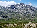
 Mali Korab and Korabska Vrata captured from Mount Korab
 -
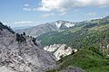
 The range from the Macedonian side
 -
 Fusha e Korabit
 -
 GlacialGramë Lake
 -
 Dešat
Dešat -
 Gypsum near the Mali i Bardhë


See also
Wikimedia Commons has media related to Mount Korab.
References
- ^ "2007 Trip Report".
- ^ "EUROPE ULTRA-PROMINENCES 99 Peaks with Prominence of 1,500 meters or greater". peaklist.org.
- ^ "RRJETI I ZONAVE TË MBROJTURA NË SHQIPËRI" (PDF). mjedisi.gov.al (in Albanian). p. 2. Archived from the original (PDF) on 2017-09-05. Retrieved 2017-09-05.
- ^ "Korab - Koritnik Natural Park Management Plan" (PDF). researchgate.net. July 2014. p. 9.
- ISBN 99927-0-397-0.