
Lærdalsøyri
Lærdalsøyri | ||
|---|---|---|
Village | ||
Region Western Norway | | |
| County | Vestland | |
| District | Sogn | |
| Municipality | Lærdal | |
| Area | ||
| • Total | 1.04 km2 (0.40 sq mi) | |
| Elevation | 3 m (10 ft) | |
| Population (2019)[1] | ||
| • Total | 1,135 | |
| • Density | 1,091/km2 (2,830/sq mi) | |
| Time zone | UTC+01:00 (CET) | |
| • Summer (DST) | UTC+02:00 (CEST) | |
| Post Code | 6887 Lærdal | |
Lærdalsøyri is the
The 1.04-square-kilometre (260-acre) village has a population (2019) of 1,135 and a population density of 1,091 inhabitants per square kilometre (2,830/sq mi).[1]
Name
The name Lærdalsøyri is derived from the local river which flows through the village. The first element is the genitive case of the old name of the river Lærr (now the river is called Lærdalselvi) and the last element is dalr which means "valley" or "dale." The meaning of the old river name is unknown..
History


The village center is listed as a national "heritage village" and tourists come to see the old city center with its 161 wooden houses that date from 1700 to 1800.[4] Old Lærdalsøyri used to be a trading port between east and west in Norway. It is located near the head of Sognefjord, one of the longest fjords in Norway, which meant sea-going ships could carry goods deep inland before landing them at the village for the over-land journey into eastern Norway.
Historically, several of the
2014 fire
At 22:56 (10:56 pm) on 18 January 2014, local fire departments were alerted to a fire in a residence on the Kyrkjegata road. Winds fanned the flames towards the town center, and the fire spread to a nearby forest, threatening the Old Lærdalsøyri heritage area. The town was evacuated at 00:30 (12:30 am), with residents evacuated to a hotel in the nearby municipality of Aurland. By 04:00 in the morning, over thirty houses were in flames.[5]
Notable residents
Media gallery
-
 Some old houses in Lærdalsøyri
 -
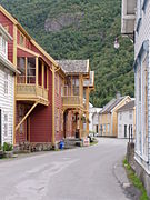 Street in Lærdalsøyri
 -
 Painting of Lærdalsøyri in 1901
 -
 Norsk Villakssenter
 -
 View of a building on Oyragata
 -
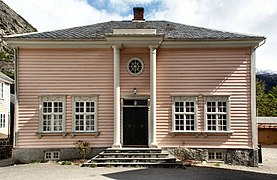 Another historic building


References
- ^ a b c Statistisk sentralbyrå (1 January 2019). "Urban settlements. Population and area, by municipality".
- ^ "Lærdalsøyri, Lærdal (Vestland)". yr.no. Retrieved 2020-01-25.
- ^ Rygh, Oluf (1919). Norske gaardnavne: Nordre Bergenhus amt (in Norwegian) (12 ed.). Kristiania, Norge: W. C. Fabritius & sønners bogtrikkeri. pp. 60–61.
- Store norske leksikon. "Lærdalsøyri"(in Norwegian). Retrieved 2010-09-06.
- ^ "Wind spreads embers considerable distance" (in Norwegian). Archived from the original on 2014-01-20. Retrieved 2014-01-18.