
Lærdal
Lærdal Municipality
Lærdal kommune | |
|---|---|
| Leirdal herred (historic name) | |
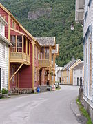
 View of Lærdalsøyri | |
|
Coat of arms | |
 Vestland within Norway | |
 Lærdal within Vestland | |
| Coordinates: 61°03′04″N 07°35′52″E / 61.05111°N 7.59778°E | |
| Country | Norway |
| County | Vestland |
| District | Sogn |
| Established | 1 Jan 1838 |
| • Created as | Formannskapsdistrikt |
| Administrative centre | Lærdalsøyri |
| Government | |
| • Mayor (2019) | Audun Mo (Ap) |
| Area | |
| • Total | 1,342.52 km2 (518.35 sq mi) |
| • Land | 1,275.43 km2 (492.45 sq mi) |
| • Water | 67.09 km2 (25.90 sq mi) 5% |
| • Rank | #71 in Norway |
| Population (2023) | |
| • Total | 2,129 |
| • Rank | #273 in Norway |
| • Density | 1.7/km2 (4/sq mi) |
| • Change (10 years) | |
| Demonym | Lærdøl[1] |
| Official language | |
| • Norwegian form | Nynorsk |
| Time zone | UTC+01:00 (CET) |
| • Summer (DST) | UTC+02:00 (CEST) |
| ISO 3166 code | NO-4642[3] |
| Website | Official website |
Lærdal is a
The 1,343-square-kilometre (519 sq mi) municipality is the 71st largest by area out of the 356 municipalities in Norway (with over half of this area consisting of mountains). Lærdal is the 273rd most populous municipality in Norway with a population of 2,129. The municipality's population density is 1.7 inhabitants per square kilometre (4.4/sq mi) and its population has decreased by 2.2% over the previous 10-year period.[4][5]
The Lærdal river valley is long, running from
General information
Lærdal was established as a municipality on 1 January 1838 (see formannskapsdistrikt law). In the 19th century, the name was sometimes spelled Leerdahl or Leirdal. The municipality of 1838 was created to be identical to the Lærdal parish (prestegjeld) that included the sub-parishes (sokn) of Borgund, Tønjum, Hauge, and Aardal. In 1863, the northeastern sub-parish of Aardal (population: 1,791) was separated from Lærdal to form a separate municipality. In 1864, the eastern sub-parish of Borgund (population: 963) was separated from Lærdal to form its own municipality. This left Lærdal with 2,777 residents.[7][8]
During the 1960s, there were many municipal mergers across Norway due to the work of the
On 1 January 2020, the municipality became part of the newly created Vestland county after Sogn og Fjordane and Hordaland counties were merged.
Name
The municipality (originally the
Coat of arms
The
Churches
The
| Parish (sokn) | Church name | Location of the church | Year built |
|---|---|---|---|
| Borgund | Borgund Church | Borgund | 1868 |
| Borgund Stave Church | c. 1150 | ||
| Hauge | Hauge Church | Lærdalsøyri | 1868 |
| Tønjum | Tønjum Church | Tønjum | 1832 |
Government
Lærdal Municipality is responsible for
Municipal council
The
| Party name (in Nynorsk) | Number of representatives | |
|---|---|---|
| Labour Party (Arbeidarpartiet) | 9 | |
| Conservative Party (Høgre) | 1 | |
| Centre Party (Senterpartiet) | 5 | |
| Socialist Left Party (Sosialistisk Venstreparti) | 2 | |
| Total number of members: | 17 | |
| Party name (in Nynorsk) | Number of representatives | |
|---|---|---|
| Labour Party (Arbeidarpartiet) | 8 | |
| Conservative Party (Høgre) | 2 | |
| Centre Party (Senterpartiet) | 5 | |
| Socialist Left Party (Sosialistisk Venstreparti) | 2 | |
| Total number of members: | 17 | |
| Party name (in Nynorsk) | Number of representatives | |
|---|---|---|
| Labour Party (Arbeidarpartiet) | 5 | |
| Conservative Party (Høgre) | 2 | |
| Centre Party (Senterpartiet) | 8 | |
| Socialist Left Party (Sosialistisk Venstreparti) | 1 | |
| Liberal Party (Venstre) | 1 | |
| Total number of members: | 17 | |
| Party name (in Nynorsk) | Number of representatives | |
|---|---|---|
| Labour Party (Arbeidarpartiet) | 4 | |
| Conservative Party (Høgre) | 3 | |
| Centre Party (Senterpartiet) | 5 | |
| Socialist Left Party (Sosialistisk Venstreparti) | 3 | |
| Liberal Party (Venstre) | 2 | |
| Total number of members: | 17 | |
| Party name (in Nynorsk) | Number of representatives | |
|---|---|---|
| Labour Party (Arbeidarpartiet) | 7 | |
| Conservative Party (Høgre) | 2 | |
| Centre Party (Senterpartiet) | 5 | |
| Socialist Left Party (Sosialistisk Venstreparti) | 2 | |
| Liberal Party (Venstre) | 1 | |
| Total number of members: | 17 | |
| Party name (in Nynorsk) | Number of representatives | |
|---|---|---|
| Labour Party (Arbeidarpartiet) | 8 | |
| Progress Party (Framstegspartiet) | 1 | |
| Socialist Left Party (Sosialistisk Venstreparti) | 3 | |
| Joint list of the Conservative Party (Høgre), Christian Democratic Party (Kristeleg Folkeparti), Centre Party (Senterpartiet), and Liberal Party (Venstre) | 5 | |
| Total number of members: | 17 | |
| Party name (in Nynorsk) | Number of representatives | |
|---|---|---|
| Labour Party (Arbeidarpartiet) | 9 | |
| Socialist Left Party (Sosialistisk Venstreparti) | 2 | |
| Joint list of the Conservative Party (Høgre), Christian Democratic Party (Kristeleg Folkeparti), Centre Party (Senterpartiet), and Liberal Party (Venstre) | 10 | |
| Total number of members: | 21 | |
| Party name (in Nynorsk) | Number of representatives | |
|---|---|---|
| Labour Party (Arbeidarpartiet) | 10 | |
| Socialist Left Party (Sosialistisk Venstreparti) | 1 | |
| Joint list of the Conservative Party (Høgre), Christian Democratic Party (Kristeleg Folkeparti), Centre Party (Senterpartiet), and Liberal Party (Venstre) | 10 | |
| Total number of members: | 21 | |
| Party name (in Nynorsk) | Number of representatives | |
|---|---|---|
| Labour Party (Arbeidarpartiet) | 8 | |
| Socialist Left Party (Sosialistisk Venstreparti) | 2 | |
| Joint list of the Conservative Party (Høgre), Christian Democratic Party (Kristeleg Folkeparti), Centre Party (Senterpartiet), and Liberal Party (Venstre) | 11 | |
| Total number of members: | 21 | |
| Party name (in Nynorsk) | Number of representatives | |
|---|---|---|
| Labour Party (Arbeidarpartiet) | 10 | |
| Conservative Party (Høgre) | 4 | |
| Joint list of the Centre Party (Senterpartiet), Christian Democratic Party (Kristeleg Folkeparti), and Liberal Party (Venstre) | 7 | |
| Total number of members: | 21 | |
| Party name (in Nynorsk) | Number of representatives | |
|---|---|---|
| Labour Party (Arbeidarpartiet) | 10 | |
| Conservative Party (Høgre) | 3 | |
| Joint list of the Centre Party (Senterpartiet), Christian Democratic Party (Kristeleg Folkeparti), and Liberal Party (Venstre) | 8 | |
| Total number of members: | 21 | |
| Party name (in Nynorsk) | Number of representatives | |
|---|---|---|
| Labour Party (Arbeidarpartiet) | 9 | |
| Joint list of the Conservative Party (Høgre), Christian Democratic Party (Kristeleg Folkeparti), New People's Party (Nye Folkepartiet), Centre Party (Senterpartiet), and Liberal Party (Venstre) | 12 | |
| Total number of members: | 21 | |
| Party name (in Nynorsk) | Number of representatives | |
|---|---|---|
| Labour Party (Arbeidarpartiet) | 10 | |
| Joint list of the Conservative Party (Høgre), Centre Party (Senterpartiet), Liberal Party (Venstre), and New People's Party (Nye Folkepartiet) | 11 | |
| Total number of members: | 21 | |
| Party name (in Nynorsk) | Number of representatives | |
|---|---|---|
| Labour Party (Arbeidarpartiet) | 12 | |
| Conservative Party (Høgre) | 2 | |
| Centre Party (Senterpartiet) | 6 | |
| Liberal Party (Venstre) | 1 | |
| Total number of members: | 21 | |
| Party name (in Nynorsk) | Number of representatives | |
|---|---|---|
| Labour Party (Arbeidarpartiet) | 12 | |
| Conservative Party (Høgre) | 1 | |
| Centre Party (Senterpartiet) | 6 | |
| Liberal Party (Venstre) | 2 | |
| Total number of members: | 21 | |
| Party name (in Nynorsk) | Number of representatives | |
|---|---|---|
| Labour Party (Arbeidarpartiet) | 11 | |
| Conservative Party (Høgre) | 2 | |
| Centre Party (Senterpartiet) | 6 | |
| Liberal Party (Venstre) | 2 | |
| Total number of members: | 21 | |
| Party name (in Nynorsk) | Number of representatives | |
|---|---|---|
| Labour Party (Arbeidarpartiet) | 9 | |
| Conservative Party (Høgre) | 2 | |
| Centre Party (Senterpartiet) | 7 | |
| Liberal Party (Venstre) | 3 | |
| Total number of members: | 21 | |
| Party name (in Nynorsk) | Number of representatives | |
|---|---|---|
| Labour Party (Arbeidarpartiet) | 8 | |
| Conservative Party (Høgre) | 1 | |
| Liberal Party (Venstre) | 4 | |
| Local List(s) (Lokale lister) | 8 | |
| Total number of members: | 21 | |
| Party name (in Nynorsk) | Number of representatives | |
|---|---|---|
| Labour Party (Arbeidarpartiet) | 10 | |
| Liberal Party (Venstre) | 5 | |
| Joint List(s) of Non-Socialist Parties (Borgarlege Felleslister) | 9 | |
| Total number of members: | 24 | |
| Party name (in Nynorsk) | Number of representatives | |
|---|---|---|
| Labour Party (Arbeidarpartiet) | 9 | |
| Joint List(s) of Non-Socialist Parties (Borgarlege Felleslister) | 15 | |
| Total number of members: | 24 | |
| Party name (in Nynorsk) | Number of representatives | |
|---|---|---|
| Labour Party (Arbeidarpartiet) | 10 | |
| Liberal Party (Venstre) | 3 | |
| Joint List(s) of Non-Socialist Parties (Borgarlege Felleslister) | 11 | |
| Total number of members: | 24 | |
| Party name (in Nynorsk) | Number of representatives | |
|---|---|---|
| Labour Party (Arbeidarpartiet) | 7 | |
| Farmers' Party (Bondepartiet) | 9 | |
| Liberal Party (Venstre) | 5 | |
| Local List(s) (Lokale lister) | 3 | |
| Total number of members: | 24 | |
| Note: Due to the German occupation of Norway during World War II, no elections were held for new municipal councils until after the war ended in 1945. | ||
Mayors
The
- 1838-1843: Nils Rossing Bull
- 1844-1845: Jan Henrik Nitter Hansen
- 1846-1847: Hannibal Winsnes
- 1848-1857: Nils Rossing Bull
- 1858-1859: Jan Rumohr
- 1860-1863: Jørgen Christian Lindstrøm
- 1864-1871: Jan Rumohr
- 1872-1875: Søren Schelderup
- 1876-1877: David Anderson Raa
- 1878-1879: Baard Lysne
- 1880-1881: Tøger Ravn
- 1882-1888: Otto Blehr
- 1889-1891: Peder Th. Tønjum
- 1896-1898: Gerhard Dahl
- 1899-1901: Tøger Ravn
- 1908-1910: Hans H. Michelsen
- 1911-1913: Haakon Mo
- 1914-1916: Hans H. Michelsen
- 1917-1922: Olav Skjær
- 1923-1925: Nils Lysne
- 1926-1937: Olav Skjær
- 1938-1942: Per Severin Hjermann (Bp)
- 1942-1945: Petter Klingenberg (NS)
- 1945-1954: Per Severin Hjermann (Bp)
- 1954-1959: Egil Natvik (V)
- 1960-1963: Ingebrigt Eri (Sp)
- 1964-1975: Anders Lunden (Ap)
- 1976-1979: Per Hjermann (Sp)
- 1980-1981: Knut L. Blaaflat (Sp)
- 1982-1989: Knut O. Hegg (Sp)
- 1990-1999: Hans A. Tønjum (Sp)
- 1999-2003: Olav Wendelbo (Sp)
- 2003–2007: Knut O. Aarethun (Ap)
- 2007–2011: Arne Sanden (Ap)
- 2011–2019: Jan Geir Solheim (Sp)
- 2019–present: Audun Mo (Ap)
Twin towns – Sister cities
Lærdal has
Geography

Lærdal is located southeast of the
The lakes Eldrevatnet, Juklevatnet, and Øljusjøen are located along the southeastern border, south of the mountain Høgeloft.
Climate
Lærdal is situated near the head of Sognefjorden. The very long fjord snakes past mountain ranges on its way from the sea inland to Lærdal, and the mountains create a
| Climate data for Lærdal 1991-2020 (2 m, Lærdal IV, extremes 1871-2020 includes earlier stations) | |||||||||||||
|---|---|---|---|---|---|---|---|---|---|---|---|---|---|
| Month | Jan | Feb | Mar | Apr | May | Jun | Jul | Aug | Sep | Oct | Nov | Dec | Year |
| Record high °C (°F) | 15.9 (60.6) |
15.3 (59.5) |
16.8 (62.2) |
21.5 (70.7) |
28.3 (82.9) |
31 (88) |
33.4 (92.1) |
31 (88) |
25.1 (77.2) |
23.6 (74.5) |
18.7 (65.7) |
16.2 (61.2) |
33.4 (92.1) |
| Mean daily maximum °C (°F) | 2 (36) |
2 (36) |
6 (43) |
11 (52) |
16 (61) |
19 (66) |
21 (70) |
20 (68) |
15 (59) |
9 (48) |
5 (41) |
2 (36) |
11 (51) |
| Daily mean °C (°F) | −0.7 (30.7) |
−0.7 (30.7) |
2.3 (36.1) |
6.4 (43.5) |
10.2 (50.4) |
13.6 (56.5) |
15.9 (60.6) |
14.8 (58.6) |
10.9 (51.6) |
5.9 (42.6) |
2.2 (36.0) |
−0.5 (31.1) |
6.7 (44.0) |
| Mean daily minimum °C (°F) | −2 (28) |
−3 (27) |
−1 (30) |
3 (37) |
6 (43) |
9 (48) |
12 (54) |
11 (52) |
8 (46) |
3 (37) |
0 (32) |
−2 (28) |
4 (39) |
| Record low °C (°F) | −21.8 (−7.2) |
−21.1 (−6.0) |
−16.7 (1.9) |
−8.8 (16.2) |
−2.5 (27.5) |
−0.6 (30.9) |
3.3 (37.9) |
2.8 (37.0) |
−2.5 (27.5) |
−10.5 (13.1) |
−16.7 (1.9) |
−19.4 (−2.9) |
−21.8 (−7.2) |
| Average precipitation mm (inches) | 45.8 (1.80) |
25.8 (1.02) |
32.1 (1.26) |
27.3 (1.07) |
29.6 (1.17) |
43.7 (1.72) |
50 (2.0) |
57 (2.2) |
55.3 (2.18) |
49.3 (1.94) |
44.7 (1.76) |
47.5 (1.87) |
508.1 (19.99) |
| Average precipitation days (≥ 1.0 mm) | 9 | 8 | 7 | 5 | 7 | 9 | 9 | 10 | 11 | 9 | 8 | 8 | 100 |
| Source 1: Norwegian Meteorological Institute/eklima (extremes)[34] yr.no/met.no (means and precipitation) [35] | |||||||||||||
| Source 2: Weatheronline climate robot (average highs/lows)[36] | |||||||||||||
Lærdal tunnel
The Lærdalstunnel was built through the Aurlandsfjell mountains dividing Aurland from Lærdal. It is the world's longest road tunnel (as of 2020[update]) at 24.5 kilometres (15.2 mi). Construction began in 1995 and was completed in 2000.[37]
Lærdalselvi river
.jpg)
The River
The river has formed a large delta at Lærdalsøyri, where huge amounts of silt and sand have been deposited by the river. Although the area has been spoiled by some unfortunate landfills it is still a sight worth seeing.
Economy
Lærdal has long traditions in farming, with the lower region of the valley being great for vegetable crops. Because of its dry climate it was one of the first places in Norway to begin the use of artificial irrigation. Despite having an inland climate, the water in the fjord keeps the winters from getting too cold.
The local Western Norway Regional Health Authority hospital provides medical care for Lærdal itself and seven of the surrounding municipalities. The hospital, together with Opplysningen 1881 (directory assistance company), Østfold Energiproduksjon A/S and Norsk Hydro Aluminium Production Facilities in Årdal, are the major employers in Lærdal. The local government and health authority is trying to close this hospital due to cost cutting, which may have negative effects on the area.
Notable people

- Norwegian Constitutional Assembly
- Anders Olson Lysne (1764 – executed 1803), a farmer who led the Lærdal farmers' rebellion from 1800 to 1802
- Jan Henrik Nitter Hansen (1801–1879), a businessman and politician who was mayor of Lærdal in the 1850s
- Rosemalingfolk art to the USA
- Eivind Blehr (1881 in Lærdal – 1957), a politician who was a government minister in Quisling's government during WWII
- Knut Rumohr (1916 in Lærdal – 2002), a Norwegian painter and printmaker
- Knut O. Aarethun(born 1942 in Lærdalsøyri), a politician who was mayor of Lærdal from 2003 to 2007
- Ragnhild Sælthun Fjørtoft (born 1947 in Lærdal), a Norwegian former TV presenter
- Øyvind Hegg-Lunde (born 1982 in Lærdal), a musician (playing drums and percussion) who was raised in Borgund
Photo gallery
-
 Lærdalsøyri
 -
 Lærdalsøyri
 -
 Old mountain pass from Aurland to Lærdal (above the Lærdalstunnelen)
 -
 Old mountain pass from Aurland to Lærdal (above the Lærdalstunnelen)
 -
 Lærdal
 -
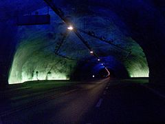 Lærdal tunnel
 -
 Lærdal tunnel cave
 -
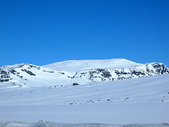 Store Jukleeggi – Mountain in Lærdal


References
- ^ "Navn på steder og personer: Innbyggjarnamn" (in Norwegian). Språkrådet.
- ^ "Forskrift om målvedtak i kommunar og fylkeskommunar" (in Norwegian). Lovdata.no.
- Store norske leksikon (in Norwegian). Kunnskapsforlaget.
- ^ Statistisk sentralbyrå. "Table: 06913: Population 1 January and population changes during the calendar year (M)" (in Norwegian).
- ^ Statistisk sentralbyrå. "09280: Area of land and fresh water (km²) (M)" (in Norwegian).
- ^ "Blaze threatens historic wood village in Laerdal Norway". BBC News. 19 January 2014. Retrieved 19 January 2014.
- ^ ISBN 9788253746845.
- ^ a b Natvik, Oddvar (9 February 2005). "Some historical data on the 26 Kommunes". Archived from the original on 13 June 2008. Retrieved 15 June 2008.
- ^ Rygh, Oluf (1919). Norske gaardnavne: Nordre Bergenhus amt (in Norwegian) (12 ed.). Kristiania, Norge: W. C. Fabritius & sønners bogtrikkeri. pp. 60–61.
- ^ "Civic heraldry of Norway - Norske Kommunevåpen". Heraldry of the World. Retrieved 13 May 2023.
- ^ "Lærdal, Sogn og Fjordane (Norway)". Flags of the World. Retrieved 13 May 2023.
- ^ "Godkjenning av våpen og flagg". Lovdata.no (in Norwegian). Norges kommunal- og arbeidsdepartementet. 18 December 1987. Retrieved 13 May 2023.
- Store norske leksikon (in Norwegian). Kunnskapsforlaget. Retrieved 14 October 2022.
- Valgdirektoratet. Retrieved 21 January 2024.
- Valgdirektoratet. Retrieved 29 October 2019.
- ^ a b c d "Table: 04813: Members of the local councils, by party/electoral list at the Municipal Council election (M)" (in Norwegian). Statistics Norway.
- Valgdirektoratet. Retrieved 29 October 2019.
- ^ "Kommunestyrevalget 1995" (PDF) (in Norwegian). Oslo-Kongsvinger: Statistisk sentralbyrå. 1996. Retrieved 18 February 2020.
- ^ "Kommunestyrevalget 1991" (PDF) (in Norwegian). Oslo-Kongsvinger: Statistisk sentralbyrå. 1993. Retrieved 18 February 2020.
- ^ "Kommunestyrevalget 1987" (PDF) (in Norwegian). Oslo-Kongsvinger: Statistisk sentralbyrå. 1988. Retrieved 18 February 2020.
- ^ "Kommunestyrevalget 1983" (PDF) (in Norwegian). Oslo-Kongsvinger: Statistisk sentralbyrå. 1984. Retrieved 18 February 2020.
- ^ "Kommunestyrevalget 1979" (PDF) (in Norwegian). Oslo: Statistisk sentralbyrå. 1979. Retrieved 18 February 2020.
- ^ "Kommunevalgene 1975" (PDF) (in Norwegian). Oslo: Statistisk sentralbyrå. 1977. Retrieved 1 May 2020.
- ^ "Kommunevalgene 1972" (PDF) (in Norwegian). Oslo: Statistisk sentralbyrå. 1973. Retrieved 1 May 2020.
- ^ "Kommunevalgene 1967" (PDF) (in Norwegian). Oslo: Statistisk sentralbyrå. 1967. Retrieved 1 May 2020.
- ^ "Kommunevalgene 1963" (PDF) (in Norwegian). Oslo: Statistisk sentralbyrå. 1964. Retrieved 1 May 2020.
- ^ "Kommunevalgene og Ordførervalgene 1959" (PDF) (in Norwegian). Oslo: Statistisk sentralbyrå. 1960. Retrieved 1 May 2020.
- ^ "Kommunevalgene og Ordførervalgene 1955" (PDF) (in Norwegian). Oslo: Statistisk sentralbyrå. 1957. Retrieved 1 May 2020.
- ^ "Kommunevalgene og Ordførervalgene 1951" (PDF) (in Norwegian). Oslo: Statistisk sentralbyrå. 1952. Retrieved 1 May 2020.
- ^ "Kommunevalgene og Ordførervalgene 1947" (PDF) (in Norwegian). Oslo: Statistisk sentralbyrå. 1948. Retrieved 1 May 2020.
- ^ "Kommunevalgene og Ordførervalgene 1945" (PDF) (in Norwegian). Oslo: Statistisk sentralbyrå. 1947. Retrieved 1 May 2020.
- ^ "Kommunevalgene og Ordførervalgene 1937" (PDF) (in Norwegian). Oslo: Statistisk sentralbyrå. 1938. Retrieved 1 May 2020.
- ^ "Ordførarar i Lærdal kommune". NRK Fylkesleksikon (in Norwegian Nynorsk). Retrieved 13 May 2023.
- ^ "Norwegian Meteorological Institute".
- ^ "yr.no Lærdal". yr.no by Norwegian Meteorological Institute. Retrieved 4 April 2021.
- ^ "Weatheronline climate robot (Molde average high and low 1996-2020)".
- ^ "The world's longest tunnel". Statens vegvesen. Archived from the original on 17 May 2008. Retrieved 18 February 2013.
External links
- Official website: Lærdal Kommune (in Norwegian)
- Municipal fact sheet from Statistics Norway (in Norwegian)
- NRK: Fylkesleksikon – Lærdal Kommune (in Norwegian)
 | Towns and cities | ||||||||||||
|---|---|---|---|---|---|---|---|---|---|---|---|---|---|
| Municipalities |
| ||||||||||||
| |||||||||||||
| Authority control databases: Geographic |
|---|