
Laufach
This article needs additional citations for verification. (May 2015) |
Laufach | |
|---|---|
Fachwerkhaus in Laufach | |
 Coat of arms | |
Location of Laufach within Aschaffenburg district 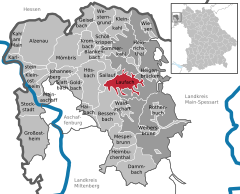 | |
Ortsteile | |
| Government | |
| • Mayor (2020–26) | Friedrich Fleckenstein[1] (SPD) |
| Area | |
| • Total | 15.60 km2 (6.02 sq mi) |
| Elevation | 180 m (590 ft) |
| Population (2022-12-31)[2] | |
| • Total | 5,317 |
| • Density | 340/km2 (880/sq mi) |
| Time zone | UTC+01:00 (CET) |
| • Summer (DST) | UTC+02:00 (CEST) |
| Postal codes | 63846 |
| Dialling codes | 06093 |
| Vehicle registration | AB |
| Website | www.laufach.de |
Laufach is a community in the Aschaffenburg district in the Regierungsbezirk of Lower Franconia (Unterfranken) in Bavaria, Germany.
Geography
Location
The community lies in northwest Bavaria east of Aschaffenburg. Laufach lies in the heart of the Vorspessart (range) and stretches through its outlying centre of Hain into the High Spessart. The community's elevation ranges from 170 to 500 m above sea level, including the peaks of Steigkoppe to the north and Steinknückl to the south.
Subdivisions
Laufach's
History
In 1084, Laufach, which was originally known as Laufahe, had its first documentary mention in an obituary from Saints Peter and Alexander collegiate church in Aschaffenburg. Laufach's name came from the stream on which it was built. Over the years, the community's name has changed many times, from Laufache in 1182, to Loifahe in 1191, to Loupha in 1348, to Lauffach around 1528 and 1624 before settling on Laufach in the early 19th century.
The Laufach valley was settled under the protection of the
In the mid-14th century, glassmakers were brought into service in the Spessart with special incentives. Since they had to leave the forest from
In the mid-18th century, in the area of today's sporting ground, a hammer mill was built. The building of a railway in the years 1850 to 1854 had a very positive effect on the community's industrial development. With the railway station, an important transport link with Aschaffenburg and the whole Lower Main was created. In the course of time, the ironworks became an integrated industry in which both the mining and the processing were done, yielding a finished product.
Even trades and crafts were important to Laufach quite early on. From earlier craft businesses grew highly productive operations.
In 1866, shortly after the Austro-Prussian War broke out, the engagements near Frohnhofen between Prussia and troops of the German Confederation took place during the Campaign of the Main (Mainfeldzug).
In 1984, the community of Laufach celebrated 900 years of existence.
Frohnhofen and the outlying centre of Hain developed into purely residential areas in which most inhabitants earned their income in the industrial and commercial businesses in Laufach, Aschaffenburg and the surrounding area. Laufach's economy underwent a shift from agriculture to industry.
To further foster commercial-industrial growth, the Laufach-Ost commercial area was developed, covering an eight-hectare area between Laufach and Hain. Another such area was developed in 2001 on a four-hectare area between Laufach and Frohnhofen.
Religion
There are a
On 28 November 1810, Laufach, together with Hain, was raised to a double parish. In 1812, a bigger church was built, which then stood on the Kirchberg until 1962. In 1964, on the same spot, a new church building was consecrated to Saint Thomas More.
In 1995, Saint Peter's Evangelical Church (Petruskirche) celebrated its 90th birthday.
Demographics
Before the Thirty Years' War began in 1618, Laufach was a village with 76 Unterthanen (a word that usually means “subjects” in German, but in this case it means “men or families”) – all together 300 inhabitants. After the disastrous war, according to a description of properties from 1651, there were 12 men and 33 “hearth places” (houses). Through an energetic promotional effort by the Elector of Mainz, the depopulated Spessart was newly settled with soldiers, craftsmen and foreigners. The old family names had disappeared and new ones made their appearance. In 1668, Laufach had 72 households and 105 inhabitants.
Until Napoleonic times, Laufach belonged to
Government
Community council
This section needs to be updated. (May 2015) |
The council is made up of 20 council members, counting the full-time mayor, Valentin Weber (
CSU |
SPD | Freie Wähler |
Total | |
| 2008 | 9 | 6 | 5 | 20 seats |
(as at municipal election held on 2 March 2008)
Coat of arms
The community's arms might be described thus: Gules a sprig of three oakleaves Or, in base a sledge and a cross-peen hammer in saltire argent.
The oakleaves shown in the arms refer to Laufach's location in the Spessart, which is rich in oaks. The crossed tools in the base are symbolic of the old iron mines and ironworks.
The arms were conferred on 19 September 1969.
The former community of Hain once bore its own arms.
Infrastructure
Transport
Laufach can be reached via the Bundesstraße 26, by rail (Laufach station on the Aschaffenburg-Würzburg line, served by the Regionalbahn) and on the nearby A 3.
Laufach is located at one end of the
Public institutions
- South of the church, on the Laufachbach (stream), stands the town hall, built in 1956 and last renovated in 2002, next to the new Laufach fire station.
- The other fire stations in Frohnhofen and Hain were renovated in 1992 and 1995 with the fire brigade's involvement. The three formerly independent fire stations in the community's three centres, under a reorganization, joined together on 1 July 2004 under the new name Feuerwehr Gemeinde Laufach.
- In 1994 the newly established Kindergarten Hain as well as the building yard in the Laufach-Ost commercial area came into service.
Education
- A combined school housing both a primary school and a Hauptschule serves youth from all three constituent communities.
- After the community's oldest gymnasium was torn down, another one was built between Laufach and the outlying centre of Frohnhofen.
References
- Bayerisches Landesamt für Statistik, 15 July 2021.
- ^ Genesis Online-Datenbank des Bayerischen Landesamtes für Statistik Tabelle 12411-003r Fortschreibung des Bevölkerungsstandes: Gemeinden, Stichtag (Einwohnerzahlen auf Grundlage des Zensus 2011).
External links
- Community’s official webpage (in German)
Towns and municipalities in Aschaffenburg (district) | ||
|---|---|---|
|  | |
| International | |
|---|---|
| National | |