
Lauwersoog
Lauwersoog | ||
|---|---|---|
Village and harbour | ||
Postal code 9976 | ||
| Dialing code | 0519 | |
Lauwersoog is a seaside village and harbour in the province of
History
As part of the
On 23 May 1969, Lauwersoog was officially established.[3] There was an agreement to locate the village in Groningen, however the decision was later disputed by Friesland. Groningen intended to use the harbour for recreational purposes only, because they were constructing the Eemshaven, as a new main harbour. Friesland and the Groninger fishing village of Zoutkamp desired a commercial harbour. In January 1970, the conflict was brought to the States General of the Netherlands.[6][7]
Lauwersoog remained in Groningen, but did become a commercial harbour. It started to specialise in fishing. From 1973 onwards, many English and German fishers started using Lauwersoog to deliver their catch, and by 1986, it was the second largest fishing harbour.[8] As a village, it was not very successful. It first appeared on maps in 1984 and has remained small.[3][1]
Transport
The ferry to Schiermonnikoog departs from Lauwersoog.[9]
Lauwersoog can be reached by car from Leeuwarden and the city of Groningen via the N361.[11][12]
Coastal trails
The E9 European long distance path passes through Lauwersoog. The Friese Kustpad is a long-distance trail from Stavoren to Lauwersoog (131 kilometres (81 mi)).[13]
Gallery
-
 Fishing port
 -
 Fish auction
 -
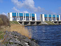 Sluice at Lauwersoog
 -
 Boats in the harbour


.jpg)

References
- ^ a b c "Kerncijfers wijken en buurten 2021". Central Bureau of Statistics. Retrieved 7 March 2022.
- ^ "Postcodetool for 9976VA". Actueel Hoogtebestand Nederland (in Dutch). Het Waterschapshuis. Retrieved 8 March 2022.
- ^ a b c d "Lauwersoog". Plaatsengids (in Dutch). Retrieved 8 March 2022.
- ^ a b Erik Betten (8 July 2008). "Lauwersoog - mooie naam, maar hij klopt niet". Friesch Dagblad (in Dutch). Archived from the original on 24 September 2015. Retrieved 8 March 2022.
- ^ "Lauwersoog of -haven". Nieuwsblad van het Noorden (in Dutch). 18 February 1964. Retrieved 8 March 2022.
- ^ "Lauwersoog bij Groningen niet in veilige handen". Nieuwsblad van het Noorden (in Dutch). 30 December 1969. Retrieved 8 March 2022.
- ^ "Hearing in gebouw Tweede Kamer". Nederlands dagblad (in Dutch). 5 January 1970. Retrieved 8 March 2022.
- ^ "Nieuw record afslag Lauwersoog". Leeuwarder courant : hoofdblad van Friesland (in Dutch). 23 January 1986. Retrieved 8 March 2022.
- ^ Wagenborg Passagiersdiensten Schiermonnikoog Retrieved on 8 March 2018.
- ^ Wagenborg Passagiersdiensten public transportation Retrieved on 8 March 2018.
- ^ "N361 Veilig". Province of Groningen (in Dutch). Retrieved 8 March 2022.
- ^ "Van Leeuwarden naar de Wadden". Visit Leeuwarden (in Dutch). Retrieved 8 March 2022.
- ^ "Friese Kustpad 131km". Voetstappen (in Dutch). Retrieved 8 March 2022.
External links
 Media related to Lauwersoog at Wikimedia Commons
| Authority control databases: National |
|---|