
Lilli Pilli, New South Wales
| Lilli Pilli Federal division(s) | Cook | ||||||||||||||
|---|---|---|---|---|---|---|---|---|---|---|---|---|---|---|---|
| |||||||||||||||


Lilli Pilli is a small suburb in southern Sydney, in the state of New South Wales, Australia. Lilli Pilli is located 26 kilometres south of the Sydney central business district, in the local government area of the Sutherland Shire.
History
Lilli Pilli was named for the
Geography
Lilli Pilli is located on the north shore of the
Lilli Pilli is surrounded by Gannons Bay, Little Turriel Bay, Port Hacking River and Great Turriel Bay. Lilli Pilli Point is situated at the end of Lilli Pilli Point Road, off Port Hacking Road. Lilli Pilli Point Bushland Reserve overlooks Royal National Park. This bushland reserve is a great secluded picnic area that is often protected from the wind. A rock ledge runs along the northern point up to Speed Alley. Many fishing spots can be found here, all the way to Little Turriell Bay.
Transport
Schools
- Lilli Pilli Primary School is on Lilli Pilli Point Road.
- Lilli Pilli Kindergarten is located nearby in Caringbah. The school has many sporting achievements, including the winning of the PSSA Soccer Division One Cup in 2008.[4]
Sport and recreation
Lilli Pilli is home to the Lilli Pilli Football Club.[5] Their homeground is Lilli Pilli Oval but other fields are also used such as Caringbah Oval, Solander Fields, Captain Cook Oval and Breen Park. Lilli Pilli is also home to 1st Lilli Pilli Sea Scouts.
In 2019, upgrades commenced to Lilli Pilli Oval's facilities, including an upgraded playing surface and clubhouse[6]
-
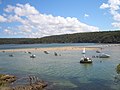 Port Hacking estuary at Lilli Pilli
 -
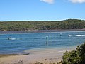 Port Hacking estuary at Lilli Pilli
 -
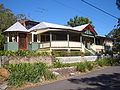 house on Lilli Pilli Point


References
- ^ Australian Bureau of Statistics (27 June 2017). "Lilli Pilli (State Suburb)". 2016 Census QuickStats. Retrieved 9 November 2017.
- ISBN 0-207-14495-8, p51
- ^ "Transdev NSW route 977". Transport for NSW.
- ^ Lilli Pilli Primary School
- ^ Lilli Pilli Football Club
- ^ "New Lilli Pilli Oval clubhouse officially opened". St George & Sutherland Shire Leader. 19 August 2019. Retrieved 24 February 2022.