
Woronora
| Woronora Federal division(s) | Hughes | ||||||||||||||
|---|---|---|---|---|---|---|---|---|---|---|---|---|---|---|---|
| |||||||||||||||
Woronora is a
Placename history
'Woronora' is an
The following meanings have been suggested for Woronora:
- 'black rock' (Appleton and Appleton 1992[5])
- 'black rocks' (Walker 1974;[2] Neve 1970[6])
- 'river-of-no-sharks' (Bolton 2000[7])
Variations such as 'black cliffs' and 'sharkless waters' have also been suggested by local residents.
The Aboriginal language known variously as
| syllables | 1 | 2 | 3 | 4 | 5 | TOTAL |
| no. words | 4 | 139 | 109 | 23 | 1 | 276 |
| % of total | 1.45% | 50.37% | 39.49% | 8.33% | 0.36% | 100% |
It therefore seems likely that Woronora is made up of two disyllabic elements.
In light of what historical Dharug information is available, the meaning of the suffix of Woronora seems most transparent. A range of phonetically similar words are present in the sources:
- ngurra 'camp' (Troy 1994:67;[8] Stockton 1993:156;[10] Mathews 1901:158[9])
- nura 'place or country' (Troy 1993:83[11])
- ngurang 'place' (Troy 1993:78[11])
- ora 'a place or country e.g. Woronora' (Kohen 1993:16[12])
- 'place; gno-rang, no-rar' (Kohen 1990:238[13])
We may tentatively conclude therefore that *-ngurra could function as a locative suffix in Dharug.
The stem of Woronora is much harder to specify. Unfortunately, no word list contains a word *wooloo, *wolo, or *woro, but the following orthographically similar words are present:
- wal-lan 'rain' (Ridley 1875:105;[14] Kohen 1993:224[12]), wulan 'rain' (Troy 1993:71[11])
- wolora 'wallaroo' (Mathews 1901:158[9]), wularu 'wallaroo' (Troy 1993:52[11]), wolaru 'kangaroo (mountain)' (Ridley 1875:104[14])
- wurral 'slow' (Mathews 1901:159[9])
- warra 'breast' (Troy 1993:34[11])
- wural 'bashful, ashamed' (Troy 1993:66[11])
- wala 'then' (Troy 1993:79[11])
- wurra 'mouse, rat' (Troy 1994:69[8])
Oft-cited definitions like 'black rocks' find no support in the written records. Words for 'black', 'shark' and 'water' do not resemble any element of Woronora, though we lack a record for the Dharug words for 'rock', 'cliff', 'river', and 'creek', and thus cannot categorically rule these out.
Guesses regarding the original form of the placename depend largely upon the degree of mishearing assumed to have taken place between the Aboriginal informant and the European recorder. Might a surveyor have missed a syllable in *wolaru-ngurra? Although English speakers frequently reproduced
Assuming therefore that the original placename most closely resembled Wooloonora, and acknowledging the inadequacy of our records due to language loss, three potential definitions present themselves:
- *wulan-ngurra 'rain place'
- *wolaru-ngurra 'wallaroo place'
- *wala-ngurra 'then place'
Cultural information could be the deciding factor in defining Woronora. Was there a Rain or Wallaroo
Geography
The residential area of Woronora lines both sides of the Woronora River. The Woronora River Bridge is northern limit to residential housing. A footbridge crosses the river at the southernmost limit of housing on the western bank. The housing on the eastern bank continues beyond the end of Prince Edward Park Road, and some houses can only be reached by a walking track or by boat.

The suburb is completely ringed by bushland, with only a single road providing access. Many think that this adds to the charm of the suburb which has curiously escaped the development that its surrounding suburbs have experienced. They feel that this has contributed to the sense of community in Woronora.
The Woronora River is tidal at this point. River levels and water quality at Woronora can be affected by the release of water from the Woronora Dam upstream from the suburb.
Woronora Plateau, is a geographical region adjacent to the Sydney Plain. Slightly higher in altitude, it is capped with Hawkesbury Sandstone. The Woronora River flows through the deeply dissected plateau to the Georges River from near the sources of the Port Hacking, within the Sutherland Shire.
Population
In the 2016 Census, there were 2,201 people in Woronora. 79.0% of people were born in Australia. The next most common country of birth was England at 5.1%. 87.6% of people spoke only English at home. The most common responses for religion were Catholic 29.0%, No Religion 26.2% and Anglican 20.6%.[1]
Transport


The Woronora Bridge was built to eliminate the steep descents and ascents for traffic between Sutherland and Menai. The bridge is approximately 600 metres long and was completed in 2001 as an alternative to the Old Woronora Bridge. There is a public path located just underneath the road on the bridge shared between bicycle and pedestrians. The path can be accessed from Menai Road on the Bangor side and Prince Edward Park Road or River Road on the Sutherland side.
Woronora Fire Trail
There is a fire trail between Woronora and
Features and facilities
Woronora features an RSL Club, boatshed, rugby league football oval (which is also a cricket ground in summer), caravan park, primary school which opened in 1942, cafe, restaurant (riverside), a fire station, hairdresser, bottle shop, general store and the Sutherland Region Guides Hall, situated by the Woronora River. It is also home to the only floating fire station in Australia to provide for residents which do not have road access.[18]
Prince Edward Park is situated between the Woronora River and Sutherland. Along the river, a cleared area was created as a recreational park, with facilities for boating and fishing. It is also the location for the Sutherland Region Girl Guides canoeing facility,[19] 1st Woronora River Scout Group and the Woronora Life Saving Club. Going towards Sutherland, the park is dense bushland, with some walking trails.
Similar to the adjoining suburbs of Bonnet Bay (where the streets are named after American Presidents) and Woronora Heights (where most streets are named after birds), Woronora has a notable street naming pattern. The majority of streets have river or water related names.
On the east side of the Woronora River there is a collection of streets named after rivers in the United Kingdom and Ireland.[20]
| Street Name | River |
|---|---|
| Tay Place | River Tay (the longest river in Scotland) |
| Severn Road | River Severn (the longest river in Great Britain) |
| Wye Close | River Wye (fourth longest river in the UK) |
| Mersey Street | River Mersey (a UK major river from Liverpool to south of Manchester) |
| Liffey Place | River Liffey (an Irish river that flows through the centre of Dublin) |
| Thames Street | River Thames (longest river in England and flows through London) |
On the west side of the Woronora River there is collection of streets which are named after Australian rural towns or waterways derived from Aboriginal language words. The Aboriginal language names often include a reference to rivers or water. These include Manilla Place, Boomi Place, Yanko Close and Nundah Place.[20]
Gallery
-
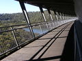 The Woronora Bridge walkway.
 -
 Menai Road, Woronora


References
- ^ a b Australian Bureau of Statistics (27 June 2017). "Woronora (State Suburb)". 2016 Census QuickStats. Retrieved 16 November 2019.
 Material was copied from this source, which is available under a Creative Commons Attribution 4.0 International License.
- ^ a b Walker, John (1974). Two hundred years in retrospect, Kurnell–Sutherland 1770–1970. Cronulla, NSW, Australia: The Cronulla Printing Co Pty Ltd.
- ^ Dixon, Robert (1837). This map of the colony of New South Wales: exhibiting the situation and extent of the appropriated lands. 18 Holborn (opposite Furnivals Inn), London: J. Cross.
{{cite book}}: CS1 maint: location (link) - ^ Mitchell, Thomas (1835). Original maps of the Hundreds in the County of Cumberland. NSW, Australia.
- ^ Appleton and Appleton (1992). The Cambridge dictionary of Australian places. Melbourne, Australia: Cambridge University Press.
- ^ Neve, Marjorie Hutton (1970). Bygone days of Sutherland Shire. Caringbah, NSW, Australia: Shire Pictorial Publications.
- ^ Bolton, Doreen (2000). Woronora. Hurstville, NSW, Australia: Parker Pattinson Publishing.
- ^ a b c Troy, Jakelin (1994). Thieberger and McGregor (ed.). Macquarie Aboriginal Words: a dictionary of words from Australian Aboriginal and Torres Strait Islander Languages. Sydney, Australia: The Macquarie Library Pty Ltd.
- ^ a b c d Mathews, R.H. (1901). "The Dharuk Language". Journal and Proceedings of the Royal Society of New South Wales for 1901. 35: 155–160.
- ^ Stockton, Eugene (1993). Blue Mountains dreaming: the Aboriginal heritage. Winmalee, NSW, Australia: Three Sisters Productions Pty Ltd.
- ^ a b c d e f g Troy, Jakelin (1993). The Sydney language. Canberra, ACT, Australia: Australian Dictionaries Project and the Australian Institute of Aboriginal and Torres Strait Islander Studies.
- ^ a b Kohen, James (1993). The Darug and their neighbours: the traditional Aboriginal owners of the Sydney region. Sydney, NSW, Australia: Blacktown and District Historical Society.
- ^ Kohen, James (1990). A dictionary of the Dharug language: the inland dialect (2nd ed.). Sydney, NSW, Australia: Blacktown and District Historical Society.
- ^ a b Ridley, William A (1875). Kamilaroi and Other Australian Languages. Sydney, Australia: Government Printer.
- ^ Donaldson, Tamsin (2002). Hercus, Hodges and Simpson (ed.). The Land is a Map: placenames of Indigenous origin in Australia. Canberra, ACT, Australia: Pandanus Books for Pacific Linguistics.
- ^ Dixon, Robert (1841). This map of the colony of New South Wales: exhibiting the situation and extent of the appropriated lands. 18 Holborn (opposite Furnivals Inn), London: J. Cross.
{{cite book}}: CS1 maint: location (link) - ^ Hercus reports such unlikely Victorian placename definitions as 'where is it?’, 'behind', and 'you come here', which suggest miscommunication between the surveyor and local informants, are in fact accurate, as they are the reported dialogue of Dreaming ancestors which took place at the sites indicated (Hercus, Luise. 2002. Is it really a placename? The Land is a Map: placenames of Indigenous origin in Australia, ed. by L. Hercus, F. Hodges and J. Simpson, 63–72. Canberra: Pandanus Books for Pacific Linguistics.)
- ^ "The Leader". The Leader. 16 September 2011.
It is also home to the only floating fire station in Australia to provide for residents which do not have road access.
- ^ "Bindaree water activities center" (PDF). girlguides-nswactnt.org.au. Retrieved 6 September 2023.
- ^ a b "Sutherland Shire Council - Origin of Street Names" (PDF). Sutherland Shire Council. Retrieved 13 September 2023.
34°01′34″S 151°02′38″E / 34.026°S 151.044°E
External links
 Media related to Woronora, New South Wales at Wikimedia Commons