Lingayen Gulf
| Lingayen Gulf | |
|---|---|
Sual |
Lingayen Gulf is a large gulf on northwestern Luzon in the Philippines, stretching 56 km (35 mi). It is framed by the provinces of Pangasinan and La Union and sits between the Zambales Mountains and the Cordillera Central. The Agno River and the Balili River drain into Lingayen Gulf.
Geography


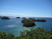
The gulf has numerous islands, the most famous of which are in the Hundred Islands National Park. This tourist attraction features 123 islands, the majority of which are small in size. The largest island is Cabarruyan Island, which constitutes the municipality of Anda, Pangasinan, followed by Santiago Island at the mouth of the Gulf.
The shore from
A number of cities are found along the gulf's coast such as
River sources
The gulf has five major river sources. Flowing from the province of Pangasinan in the south are the Agno, Dagupan and Angalacan-Bued rivers. From the east in the province of La Union flow the Aringay and Bauang rivers.[2]
History

During
At 09:30 on 9 January 1945, the
Despite the Americans' success in driving out the Japanese army encamped at the gulf, the Americans suffered relatively heavy losses, particularly on their convoys due to Japanese
Following the amphibious landings, Lingayen Gulf was turned into a
Commemoration
On January 9, 2008, Gov. Amado Espino Jr. and Vice Gov. Marlyn Primicias-Agabas established an annual commemoration to honor the war veterans. The resolution named January 9 as
Economy
Fishing and salt-making are the primary industries on Lingayen Gulf. In fact, the name Pangasinan literally means "place where salt is made". Salt is collected from seawater through evaporation, leaving the crystalline salt behind.
Lingayen Gulf is also home to the 1200 megawatt Sual Power Station, the Philippines largest coal power plant.
References
- ISBN 1-74104-289-5
- ISBN 9789711022495. Retrieved 4 February 2016.
- ^ Encyclopedia of American History
- ^ Pacific wrecks - Lingayan Gulf
- ^ Abs-Cbn Interactive, 63rd anniversary of Lingayen Gulf Landing commemorated
External links
 Media related to Lingayen Gulf at Wikimedia Commons

