
Main Street Unionville
This article needs additional citations for verification. (October 2020) |
Highway 7 | |
|---|---|
| North end | Rosemary Close |
| Construction | |
| Inauguration | 1840 |
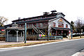
Main Street Unionville is a collector route that runs through the historical suburban community of Unionville, in Markham, Ontario, Canada. Like most other Main Streets, the street serves as an important road for local tourism development. All along the road, the street has structures that are virtually unchanged from its founding in 1794. Renowned for its pubs, parks, restaurants, and its historical European view, the road also hosts the annual Unionville Festival, which draws several thousand visitors to the neighbourhood.
Road Information
- Local name: Main Street
- Attractions: Historical Village of Unionville, Varley Gallery, Starks Barber Company
- Road Status: From Unionville Gate to Carlton Road, the road is a paved 2-lane avenue, with a speed limit of 40 km/h. However, the right lane is often blocked due to parked vehicles left by tourists. North of Carlton Road, the road is a paved, two-lane street.
- Zonings: Mainly commercial and parklands, with residential zonings from 1794.
History
Entertainment
Main Street Unionville hosts annual jazz and Celtic festivals, as well as live music in the new bandstand in the summer. The street was also used as a stand-in for fictional Connecticut town Stars Hollow during the first season of The WB's Gilmore Girls television show. Other productions to have used Main Street as a filming location include The Scream Team in 2002, and Secrets of Eden in 2011.
The 1994 John Carpenter film, In the Mouth of Madness prominently features the northernmost part of the street as a stand-in for a fictional New England town, especially the exterior of the Unionville Arms Pub.
Road History
Main Street Unionville was the original 6th line of Markham Township. This road was undeveloped until about 1840 when the mill was developed at what is now Carlton Road. The mill needed the water from the pond to the north-west but the swamp to its immediate south made travel virtually impossible. The common road developed along the ridge to the south, and this became the main passageway. About this time the area on the north-west corner of the road and 15th Avenue (later
Settlement History
Landmarks
- Historical Village of Unionville
- Varley Art Gallery
- Unionville Library
- Unionville Village Firehall
-
 Central United Church
 -
 Old Unionville church, built by the architect of Casa Loma
 -
 Unionville Planing Mill
 -
 Unionville Main Street
 -
 Toogood Pond


Major Intersections
The following table lists the major junctions along Main Street Unionville.[1] The entire route is located in Markham, Ontario, within the Regional Municipality of York.
| km[1] | mi | Destinations | Notes | ||
|---|---|---|---|---|---|
| 0.0 | 0.0 | Cul-de-sac south of Enterprise Avenue | |||
| 0.2 | 0.12 | Enterprise Avenue / Unionville Gate | Markham Pan Am Centre located southwest of intersection | ||
| 0.8 | 0.50 | Highway 7 | |||
| 1.7 | 1.1 | Carlton Road | |||
| 2.4 | 1.5 | Rosemead Close | Exit of Fire Station north of intersection | ||
| 1.000 mi = 1.609 km; 1.000 km = 0.621 mi | |||||
References
- ^ Google (3 March 2019). "Length and route of existing Main Street Unionville" (Map). Google Maps. Google. Retrieved 3 March 2019.
Roads in Markham | ||
|---|---|---|
| East-West Municipal Roads: |
|  |
| North-South Municipal Roads: |
| |
| Regional Roads: |
| |
| Highways and Expressways: | ||
| See also | ||