
Malatia-Sebastia District
Malatia-Sebastia Մալաթիա-Սեբաստիա | |
|---|---|
UTC+4 ( ) |
Malatia-Sebastia (Armenian: Մալաթիա-Սեբաստիա վարչական շրջան, Malat’ia-Sebastia varch’akan shrjan), also nicknamed colloquially as Bangladesh,[1] is one of the 12 districts of Yerevan, the capital of Armenia, located in the western part of the city. As of the 2011 census, the district has a population of 132,900.
Malatia-Sebastia is bordered by the Ajapnyak District form the north, Kentron District from the east and Shengavit District from the south. It also has borders with the Armavir Province from the east and the Ararat Province from the southeast.[2]
The name of the community is derived from two former major historically partly Armenian towns in modern-day Turkey; Malatya and Sivas.
The district is unofficially divided into smaller neighborhoods such as: Nor Malatia, Zoravar Andranik, Shahumyan, Araratyan and Haghtanak.
History
In 1925,
In 1996, Malatia and Sebastia were merged into one district called Malatia-Sebastia, to become one of the 12 districts of Yerevan.
The district is home to the Sebastia Silk Factory and the RAO MARS Metal Factory. Zvartnots International Airport is in the outskirts of Malatia-Sebastia, to the southwest of the district.
Streets and landmarks

.jpg)
Main streets
- Admiral Isakov Avenue.
- Raffi street.
- Sebastia street.
- Tichina street.
- Arno Babajanian street.
- Zoravar Andranik street.
- Daniel Varujan street.
- Gusan Sheram street.
Landmarks
- Church of the Holy Mother of God of Malatia.
- Holy Trinity Church
- Yerablur military cemetery and the Holy Martyrs Vartanants chapel
- Holy Cross Russian Orthodox Church (under construction)
- Patriotic War Memorial Park
- Youth Park
- Vahan Zatikyan Park
- Malatia Garden
- Maternity Park
- Love and Faith Park
- Chinar Garden
- Yuri Bakhshyan Park
- Italian Park
- Armenicum Center
- Mkhitar Sebastatsi Educational Complex
- Khoren and Shooshanig Avedisian School
- Banants Training Centre
- Urartu Stadium
- Yerevan Velodrome cycling circuit
- Dalma Garden Mall
Gallery

- Malatia-Sebastia district
-
 Nagorno-Karabakh conflict memorial
 -
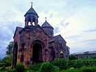 Church of the Holy Mother of God, Malatia-Sebastia District
 -
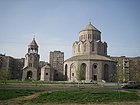 The Holy Trinity Church, Malatia-Sebastia District
 -
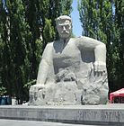 The statue of General Andranik
 -
 The statue of Gregory of Narek


.jpg)
.jpg)
References
- ISBN 978-0814326046.
- ^ "yerevan.am | Պաշտոնական կայք | Մալաթիա-Սեբաստիա վարչական շրջան". www.yerevan.am. Retrieved Jan 5, 2021.