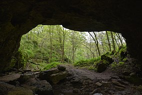
Maquoketa Caves State Park
| Maquoketa Caves State Park | |
|---|---|
 | |
| Location | Jackson, Iowa, United States |
| Coordinates | 42°7′6″N 90°46′41″W / 42.11833°N 90.77806°W |
| Area | 323 acres (131 ha) |
| Elevation | 817 ft (249 m)[1] |
| Established | 1921 |
| Governing body | Iowa Department of Natural Resources |
| Website | Maquoketa Caves State Park |
Maquoketa Caves State Park Historic District | |
| NRHP reference No. | 91001843[2] |
| Added to NRHP | December 23, 1991 |
Maquoketa Caves State Park is a state park of Iowa, United States, located in Jackson County. It stands northwest of the city of Maquoketa. In 1991 111 acres (45 ha) on the east side of the park were listed as a historic district on the National Register of Historic Places.[2]
Description
The park contains more
The park is in the Driftless Area of Iowa. This region escaped being glaciated in the last ice age, while regions to the east and west were not spared. The park has been subjected to hundreds of thousands of years of natural non-glacial erosion. [citation needed]
The park's caves,
Today a modern interpretive center outside the park entrance provides maps and other informational materials. Inside the park, a central map kiosk includes charts of some of the more interesting caves. [citation needed]
History
Artifacts such as pottery, as well as tools and projectile points made of stone have been found in the caves and surrounding area. These discoveries indicate that the Maquoketa Caves area has been of interest to humans for hundreds, perhaps thousands, of years. Early recorded history tells that the Native Americans in the area were likely visitors to the Raccoon Creek valleys. The first Euro-American explorers first visited the caves as late as the mid-1830s. The area was originally known as Morehead Caves or Burt's Cave.[4] It had become a popular place for exploration, picnics, parties, and dances by the 1860s. A dance floor was constructed north of Natural Bridge in 1868, and a pavilion, which was used until the 1920s, was built sometime later. By the turn of the 20th century the area had become seriously degraded, and its popularity declined.
The first park land was purchased in 1921 by the Maquoketa Women's Club for the purposes of establishing a state park. Originally called Morehead Caves State Park, its name was changed to Maquoketa Caves in 1928.
The State of Iowa purchased an additional 161 acres (65 ha) on the west side of the park between 1961 and 1981. This section was dedicated as a nature preserve.[4]
In popular culture
The park was once featured on an episode of Rescue 911 when a story was done on a hiker who had fallen and was seriously injured while at the park. The hiker was saved by paramedics and the Maquoketa volunteer fire department.
Familicide
In the early morning of July 22, 2022, an assailant killed three members of a family at the campground. The assailant, identified as 23-year-old Anthony Sherwin of Nebraska, later committed suicide.[5]
See also
References
- ^ "Maquoketa Caves State Park". Geographic Names Information System. United States Geological Survey. April 30, 1979. Retrieved February 27, 2011.
- ^ a b "National Register Information System". National Register of Historic Places. National Park Service. July 9, 2010.
- ^ "Maquoketa Caves State Park". Iowa Department of Natural Resources. Retrieved June 15, 2016.
- ^ a b c d e Rebecca Conard. "Maquoketa Caves State Park Historic District". National Park Service. Retrieved June 15, 2016. with 15 photos from 1991
- ^ "Police: Gunman kills 3 at Iowa state park; shooter also dead". AP NEWS. July 22, 2022. Retrieved July 22, 2022.

