
Mearley
| Mearley | ||
|---|---|---|
Shire county | ||
| Region | ||
| Country | England | |
| Sovereign state | United Kingdom | |
| Post town | CLITHEROE | |
| Postcode district | BB7 | |
| Dialling code | 01200 | |
| Police | Lancashire | |
| Fire | Lancashire | |
| Ambulance | North West | |
| UK Parliament | ||
Mearley is a
parish council, but instead has a parish meeting shared with neighbouring Worston. From the 2011 Census population information for both Mearley and Worston is included within the civil parish of Pendleton, giving a total of 349.[2] The eastern part of the parish is included in the Pendle outlier section of the Forest of Bowland Area of Outstanding Natural Beauty (AONB).[3]
The parish adjoins the Ribble Valley parishes of Worston, Clitheroe, Pendleton and Sabden, along with Goldshaw Booth in the Borough of Pendle.
The name is thought to mean the meadow or
Mearley was once a
civil parish in 1866, forming part of the Clitheroe Rural District from 1894 till 1974.[5]
Along with
-
 Mearley Hall farmhouse
 -
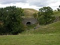 A disused lime kiln near Mearley Hall
 -
 Mearley Brook runs through the north of the parish
 -
 Mearley Moor viewed from Pendleton


See also
References
- ^ a b "Parish headcount" (PDF). Archived from the original (PDF) on 10 December 2006. Retrieved 26 December 2021.
- Office for National Statistics. Retrieved 26 December 2021.
- ^ Forest of Bowland map (Map). forestofbowland.com. Lancashire County Council. Retrieved 26 December 2021.
- ^ Ekwall, Eilert (1922). The place-names of Lancashire. Manchester University Press. pp. 14, 78. Retrieved 26 December 2021.
- ^ "Mearley Tn/CP through time". visionofbritain.org.uk. GB Historical GIS / University of Portsmouth. Retrieved 26 December 2021.
- ^ "Wiswell and Pendleton". MARIO. Lancashire County Council. Retrieved 26 December 2021.
- ^ "Wiswell and Pendleton". Ordnance Survey Linked Data Platform. Ordnance Survey. Retrieved 26 December 2021.
External links
![]() Media related to Mearley at Wikimedia Commons
Media related to Mearley at Wikimedia Commons
This Lancashire location article is a stub. You can help Wikipedia by expanding it. |