
Newton-in-Bowland
| Newton | ||
|---|---|---|
Shire county | ||
| Region | ||
| Country | England | |
| Sovereign state | United Kingdom | |
| Post town | Clitheroe | |
| Postcode district | BB7 | |
| Dialling code | 01200 | |
| Police | Lancashire | |
| Fire | Lancashire | |
| Ambulance | North West | |
| UK Parliament | ||
Newton or Newton-in-Bowland is a village and
The village pub – The Parkers Arms – takes its name from the neighbouring Parker family of
History
Recorded in
From the late eleventh century, the
Two of the
Knowlmere was a mesne manor of the
Title to the Manor and Liberty of Slaidburn, West Bradford and Grindleton, including the township of Newton, was bought by Tory MP, Ralph Assheton, later first Baron Clitheroe, in 1950.[12] In 1977, his second son, the Hon Nicholas Assheton, was granted title.[13] Since 2003, the Lord of the Manor and Liberty of Slaidburn has been Thomas Assheton, son of the Hon Nicholas Assheton and nephew of the second Baron Clitheroe.[7][14]
Newton was an early centre of
Geography
The
The River Hodder flows through Newton, joined by Easington Brook on the eastern edge of the village, and Foulscales Brook a little further south. The confluence of Foulscales Brook and the Hodder is the location of Barge Ford, considered to be the mysterious Bogeuurde mentioned in Domesday[11] and by some, linked to the early origins of the manor of Knowlmere. Close by sits Foulscales Farm, a fourteenth-century hall, the oldest dwelling in Bowland, tenanted by the Eastwood family, descendants of Richard Eastwood (d. 1871), Bowbearer of the Forest of Bowland and founder of St Hubert's Catholic Chapel, Dunsop Bridge.
Governance
The civil parish of Newton was created from the township of the same name in 1866. In 1938, the geographically non-contiguous division of Lower Easington was transferred to Newton.[19]
Along with
Media gallery
-
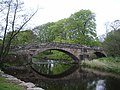 Newton Bridge
 -
 Footbridge over River Hodder
 -
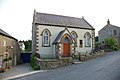 Newton Chapel
 -
 Dunnow Hall
 -
 The Parkers Arms
 -
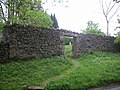 Quaker Burial Ground


See also
References
C J Spencer; S W Jolly. "Bowland: the rise and decline, abandonment and revival of a medieval lordship" (PDF). The Escutcheon: Journal of the Cambridge University Heraldic & Genealogical Society. Archived from the original (PDF) on 11 July 2011.
- ^ "Census 2001 : Parish Headcounts : Ribble Valley". Office for National Statistics. Retrieved 24 April 2011.
- Office for National Statistics. Retrieved 24 February 2018.
- ^ "Lord of the Fells, Guardian of History" (PDF). Rural Life. November 2014.
- ^ "The Parkers Arms | www.parkersarms.co.uk".
- ^ Jenny Bradley, Slaidburn: A Walk through the Village (Slaidburn Village Archive 2011), p. 6
- ^ Slaidburn Court Rolls, 16th year of reign of Richard II, 1392/3, No 1: 8 membranes, 1 wrapper, Lancashire Record Office, DDHC1; William Farrer, Latin transcription (1900), Manchester City Archive
- ^ a b c Spencer and Jolly: Escutcheon Vol 15
- ^ RW Hoyle, The Pilgrimage of Grace and the Politics of the 1530s(Oxford University Press 2001)
- ^ J Porter, The Forest of Bowland: Its Landscape and History (Farnborough 1994), p. 37
- ^ Alice Peel, The Manor of Knowlmere (Privately published: Knowlmere 1913)
- ^ a b Eilert Ekwall, The Place-names of Lancashire (Manchester University Press: Manchester 1922)
- ^ HM Land Registry, 22 June 1950
- ^ HM Land Registry, 26 August 1977
- ^ HM Land Registry, LA937696, 1 June 2003; ownership of common land is registered under LA955806, LA955807, LA955808, LA955809
- ^ Henry Fishwick, ed., The Notebook of the Rev Thomas Jollie, AD 1671-1693 (Chetham Society: Manchester 1894)
- ^ William Bowland, The Lord and the Preacher http://www.forestofbowland.com/files/uploads/THE_LORD_AND_THE_PREACHER%20minus%20picture%20Nov%202010.pdf Archived 11 September 2011 at the Wayback Machine
- ^ Final Service at 125-year-old Chapel,Clitheroe Advertiser,17 June 2012
- ^ Brian Dale, Bicentenary of Nonconformity in the Village of Newton in Bowland (William Byles: Bradford 1897)
- ^ "History of NEWTON". visionofbritain.org.uk. Archived from the original on 24 December 2012. Retrieved 30 April 2011.
- ^ "Bowland, Newton and Slaidburn". MARIO. Lancashire County Council. Retrieved 25 March 2016.
- ^ "Bowland, Newton and Slaidburn". Ordnance Survey Linked Data Platform. Ordnance Survey. Retrieved 25 March 2016.