
Medina of Tunis
This article needs additional citations for verification. (May 2017) |
UNESCO World Heritage Site | |
|---|---|
 Roofs of the Medina | |
| Location | Tunis, Tunisia |
| Criteria | (ii)(iii)(v) |
| Reference | 36bis |
| Inscription | 1979 (3rd Session) |
| Extensions | 2010 |
| Area | 296.41 ha (732.4 acres) |
| Buffer zone | 190.19 ha (470.0 acres) |
| Coordinates | 36°49′N 10°10′E / 36.817°N 10.167°E |
 Location of Medina of Tunis in Tunisia | |
The Medina of Tunis is the
The Medina contains some 700 monuments, including
History
Founded in 698 around the original core of the Zitouna Mosque, the Medina of Tunis developed throughout the Middle Ages.[3] The main axis was between the mosque and the centre of government to the west in the kasbah. To the east this same main road extended to the Bab el Bhar. Expansions to the north and south divided the main Medina into two suburbs north (Bab Souika) and south (Bab El Jazira).[4]
Before the
Social and urban structure

With an area of 270 hectares (670 acres)[8] (plus 29 hectares (72 acres) for the district of the kasbah) and nearly 110,000 inhabitants, the Medina has one-tenth of the population of Tunis and a sixth of the urbanized area of the agglomeration.
The complex organization of the urban fabric fueled an entire colonial literature of the dangerous Medina, anarchic and chaotic, and the territory of ambush. However, since the 1930s, with the arrival of the first ethnologists, studies have revealed that the articulation of the Medina areas is not random, and houses are built according to clear sociocultural norms, codified according to complex types of human relationships. Many publications have detailed the development of the Medina model and system of prioritization of public and private spaces, residential and commercial, sacred and profane.
The urban layout of the Medina of Tunis has the distinction of not obeying geometrical layouts or formal compositions such as
The concept of public space is ambiguous in the Medina where the streets are considered as the extension of houses and subject to social tags. The notion of individual ownership is low and displays in the souks often spill out onto the highway. This idea is reinforced by the area of a shop (about 3 m2) and bedroom (10 m2).
-
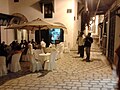 Evening at Ramdhane Bey Square
 -
 Ramdhane Bey Square
 -
 El Halfaouine street
 -
 Bir lahjar Street


In the case of domestic architecture, the more a building is set back from the shops, the more it is valued. The concept of withdrawal and privacy is paramount. The late introduction of a sewer system means that much waste water still flows through the streets of the Medina. The largest houses and noble places are generally located in the district with the highest elevation, the Kasbah quarter. The roof terraces of the Medina are also an important place for social life, as illustrated by the film Halfaouine by Férid Boughedir.
Nowadays, every district retains its culture and rivalries can be strong. Thus, the northern suburb supports the football club Espérance Sportive de Tunis while the southern side is the district of the rival Club Africain. The Medina has also witnessed a social segmentation: the districts of Tourbet el Bey and the kasbah are wealthier, with a population of judges and politicians, Pasha street is the military and the bourgeoisie (merchants and notables), and smaller communities such as Hafisa where the Jewish population have traditionally lived.[clarification needed]
Architecture
.jpg)
The
The Husainid ruler Ali II ibn Hussein (1759–1782) had the Tourbet el Bey constructed in the south of the Medina as a mausoleum for his family,[11][12] It is the largest funerary monument in Tunis.[13]
In the time of Muhammad III as-Sadiq (1859–1882) the walls of the Medina were in such bad repair that in some places they threatened to collapse. In 1865 he began demolishing them, along with a number of the Medina's historic gates: Bab Cartagena, Bab Souika, Bab Bnet and Bab El Jazira.
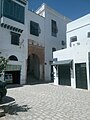
Domestic architecture
-
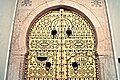 Close-up on a traditional door of the Medina
 -
 Vestibule of Dar Othman


Landmarks
City gates


Madrasas
Since the
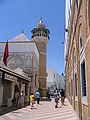
Mosques

The Medina contains most of the great mosques of the capital, which were all built before the French protectorate.
The main
The
The
The Youssef Dey Mosque functioned first as an oratory before becoming a mosque in 1631, and is the first mosque of the Ottoman-Turkish period. The Hammouda-Pacha mosque, built in 1655, was the second mosque of the Hanefite rite built in Tunis while the Sidi Mahrez mosque is the largest mosque of this type in the country. Built from 1692 to 1697, it is Ottoman-inspired and recalls some Istanbul mosques such as the Blue Mosque (erected between 1609 and 1616) and the Yeni Valide (completed in 1663). The El Jedid Mosque, built by the founder of the Hussein dynasty Hussein the Ist Bey between 1723 and 1727, has, like the Youssef Dey and Hammouda-Pacha mosques, an Ottoman-inspired octagonal minaret.
-

-
 Zitouna Mosque Court
 -
 El Ksar Mosque dating from 12th century (with the exception of its minaret built 17th century)
 -
 Youssef Dey Mosque (First half of the 17th century)
 -
 Prayer room of the mosque Sidi Mahrez (End of the 17th century)
 -
 View of the mosque Saheb Ettabaâ (beginning of 19th century)


Palaces
The palaces or the Dars are one of the most important historical monuments in the ancient city of Tunis, which were inhabited by politicians, wealthy class and dignitaries of the city.
-
 Dar Lasram
 -
 Dar Ben Achour
 -
 Dar Al Jaziri


Climate change
As a coastal heritage site, Medina of Tunis is vulnerable to
See also
- Religion in Tunisia
- Sainte-Croix Church of Tunis, a former church building
- Sidi Abdallah Cherif Mausoleum
- Moorish architecture
References
- ^ "WH Committee: Report of 3rd Session, Cairo 1979". whc.unesco.org. Retrieved 11 June 2017.
- ^ "Medina of Tunis". whc.unesco.org. Retrieved 11 June 2017.
- ^ Richard C. Jankowsky, Stambeli: Music, Trance, and Alterity in Tunisia, University of Chicago Press, 2010 p.35 accessed 11 June 2017
- ^ http://www.persee.fr/doc/etaf_0768-2352_1967_mon_1_1 p.31 accessed 1 May 2017
- ^ Smart S. Baadj, Saladin, the Almohads and the Banū Ghāniya: The Contest for North Africa (12th and 13th centuries), BRILL, 2015 p.158 Retrieved 12 June 2017
- ^ Joseph W. Meri, Medieval Islamic Civilization: An Encyclopedia, Routledge, 2005 p.309 accessed 11 June 2017
- ^ Palais et demeures de Tunis (XVIe et XVIIe siècles) [monographie] p.31
- ^ Michael Pacione, Problems and Planning in Third World Cities (Routledge Revivals), Routledge, 2013 p.100, accessed 11 June 2017
- ^ Ibn Abi Dhiaf, op. cit, p. 43
- ^ Ibn Abi Dhiaf, Présent des hommes de notre temps. Chroniques des rois de Tunis et du pacte fondamental, vol. II, éd. Maison tunisienne de l'édition, Tunis, 1990, p. 55
- ^ Georges Pillement, La Tunisie inconnue, ed. Albin Michel, Paris, 1972, p. 66
- ^ Tourbet El Bey (Association de sauvegarde de la médina de Tunis) Archived 2016-03-07 at the Wayback Machine
- ^ Adel Latrech, "Promenade dans les tourbas de Tunis", La Presse de Tunisie, 28 August 2010. Archived 2011-07-22 at the Wayback Machine
- ^ "Dynasty". www.discoverislamicart.org. Retrieved 1 May 2017.
- ^ Trisos, C.H., I.O. Adelekan, E. Totin, A. Ayanlade, J. Efitre, A. Gemeda, K. Kalaba, C. Lennard, C. Masao, Y. Mgaya, G. Ngaruiya, D. Olago, N.P. Simpson, and S. Zakieldeen 2022: Chapter 9: Africa. In Climate Change 2022: Impacts, Adaptation and Vulnerability [H.-O. Pörtner, D.C. Roberts, M. Tignor, E.S. Poloczanska, K. Mintenbeck, A. Alegría, M. Craig, S. Langsdorf, S. Löschke,V. Möller, A. Okem, B. Rama (eds.)]. Cambridge University Press, Cambridge, United Kingdom and New York, NY, USA, pp. 2043–2121
- PMID 31996825.
- PMID 33082220.
- ^ Technical Summary. In: Climate Change 2021: The Physical Science Basis. Contribution of Working Group I to the Sixth Assessment Report of the Intergovernmental Panel on Climate Change (PDF). IPCC. August 2021. p. TS14. Retrieved 12 November 2021.
- ^ IPCC, 2021: Summary for Policymakers. In: Climate Change 2021: The Physical Science Basis. Contribution of Working Group I to the Sixth Assessment Report of the Intergovernmental Panel on Climate Change [Masson-Delmotte, V., P. Zhai, A. Pirani, S.L. Connors, C. Péan, S. Berger, N. Caud, Y. Chen, L. Goldfarb, M.I. Gomis, M. Huang, K. Leitzell, E. Lonnoy, J.B.R. Matthews, T.K. Maycock, T. Waterfield, O. Yelekçi, R. Yu, and B. Zhou (eds.)]. Cambridge University Press, Cambridge, United Kingdom and New York, NY, USA, pp. 3−32, doi:10.1017/9781009157896.001.
External links
- Association pour la sauvegarde de la medina de Tunis (in French)
- UNESCO site on the Tunis Medina
- the Hafsia quarter of the medina of Tunis
- the former Jewish quarter (hara) of the medina
| ||