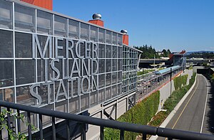
Mercer Island station
Mercer Island | ||||||||||||||||
|---|---|---|---|---|---|---|---|---|---|---|---|---|---|---|---|---|
| Link light rail station | ||||||||||||||||
 West entrance under construction in August 2022 | ||||||||||||||||
| General information | ||||||||||||||||
| Location | Mercer Island, Washington United States | |||||||||||||||
| Coordinates | 47°35′17″N 122°14′00″W / 47.58806°N 122.23333°W | |||||||||||||||
| Owned by | Sound Transit | |||||||||||||||
| Platforms | 1 island platform | |||||||||||||||
| Tracks | 2 | |||||||||||||||
| Construction | ||||||||||||||||
| Structure type | Below-grade | |||||||||||||||
| Accessible | Yes | |||||||||||||||
| History | ||||||||||||||||
| Opening | 2025 | |||||||||||||||
| Services | ||||||||||||||||
| ||||||||||||||||
Mercer Island station is a future light rail station on the 2 Line of the Link light rail network operated by Sound Transit. It will serve the city of Mercer Island and is located in the median of Interstate 90 at the north end of the island. The station is scheduled to open in 2025 as part of the 2 Line section that crosses Lake Washington between Seattle and the Eastside.[1]
Location
The station is located in the middle of Interstate 90 in what was formerly the freeway's express lanes. It has entrances at 77th Ave SE to the west and 80th Ave SE to the east.[2] This location is just south of the Mercer Island Park & Ride and just north of Mercer Island's business district.
References
- ^ Lindblom, Mike (August 24, 2023). "Eastside-only light rail should open in March, Sound Transit says". The Seattle Times. Retrieved August 24, 2023.
- ^ "From Paper to Pavement: Light Rail Station at North Mercer Park & Ride". Mercer Island Reporter. 24 November 2008. Archived from the original on 2023-08-13. Retrieved 2009-08-19.

