
Mook en Middelaar
Mook en Middelaar
Mook en Middelar | |
|---|---|
Meuse | |
|
UTC+2 (CEST) | |
| Postcode | 6584–6587 |
| Area code | 024 |
| Website | mookenmiddelaar |

Mook en Middelaar (Dutch:
Population centres
History
The municipality is situated in wooded rolling moraine landscape, created during the last ice age, about 160,000 years ago.
In Plasmolen the remains of a Roman villa from the 2nd century AD were found and on the banks of the
The Mookerheide ("Mook Heath"), situated on the border of Mook, saw the
The Mookerschans and Heumense schans were defenses on the Mookerheide probably from the 17th century. (At that time the Mookerheide area extended all the way to the citywalls of Nijmegen) The historical Mookerheideschans (defense work) has been restored and offers a beautiful view over the Meuse valley.
Middelaar belonged to Overkwartier (Upper Quarter) of
In the
To support the cement industry, sand was dug out in the fields next to the river Maas (known as 'Cuyksesteeg') which consequently lead to the forming of the Mookerplassen recreational lakes, between Middelaar and the Mookerheide. After a couple of floodings in the 80s and 90s a removable lock was built to save the area from flooding again.
Public transport
Mook and the municipality is served by three bus lines and has its own train station, Mook-Molenhoek railway station.
Notable residents
- Karel Martens (born 1939) a Dutch freelance graphic designer, specialises in typography
- Serge Daan (1940–2018) a Dutch scientist, contributed to the field of chronobiology
- Arjen Teeuwissen (born 1971), equestrian, team silver medallist at the 2000 Summer Olympics
- Marko Koers (born 1972) a retired middle distance runner, competed at three consecutive Summer Olympics from 1992
Gallery
-
 Mook, former town hall
 -
 Mook, church
 -
 Mookerplas
 -
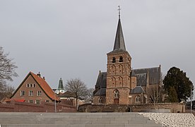
 Middelaar, church
 -
 Molenhoek-stationsstraat
 -
 Mookerheide near Mook
 -
 Molenhoek church, Mook en Middelaar
 -
 Mookerheide


_church.JPG)

References
- ^ "College van burgemeester en wethouders" [Board of mayor and aldermen] (in Dutch). Gemeente Mook en Middelaar. Archived from the original on 11 November 2013. Retrieved 11 November 2013.
- ^ "Kerncijfers wijken en buurten 2020" [Key figures for neighbourhoods 2020]. StatLine (in Dutch). CBS. 24 July 2020. Retrieved 19 September 2020.
- ^ "Postcodetool for 6585AP". Actueel Hoogtebestand Nederland (in Dutch). Het Waterschapshuis. Retrieved 11 November 2013.
- ^ "Bevolkingsontwikkeling; regio per maand" [Population growth; regions per month]. CBS Statline (in Dutch). CBS. 1 January 2021. Retrieved 2 January 2022.
External links
 Media related to Mook en Middelaar at Wikimedia Commons
- Official website
Places adjacent to Mook en Middelaar | ||||||||||||||||
|---|---|---|---|---|---|---|---|---|---|---|---|---|---|---|---|---|
| ||||||||||||||||

| Authority control databases: Geographic |
|---|