
Mount Benzarino
| Mount Benzarino | |
|---|---|
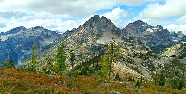
 Benzarino's east aspect seen from Maple Pass Trail | |
| Highest point | |
| Elevation | 7,760 ft (2,370 m)[1] |
| Prominence | 720 ft (220 m)[1] |
| Parent peak | Corteo Peak (8,080 ft)[2] |
| Isolation | 1.66 mi (2.67 km)[2] |
| Coordinates | 48°29′23″N 120°49′02″W / 48.489723°N 120.817091°W[1] |
| Geography | |
 Mount Benzarino Location of Mount Benzarino in Washington  Mount Benzarino Mount Benzarino (the United States) | |
| Country | United States |
| State | class 3 scrambling[2] |
Mount Benzarino is a 7,760+ ft (2,370+ m) mountain summit located in
Corteo Peak and Mount Benzarino were named by Forest Service surveyor, Lage Wernstedt, for the names of Basque sheepherders he met near these two mountains.[5][6] Lage Wernstedt made the first ascent of Benzarino in 1926.[7] Remnants of a small glacier hang on its north flank, and precipitation runoff from the mountain drains into tributaries of Bridge Creek, which in turn is a tributary of the Stehekin River.
Climate
Mount Benzarino is located in the
Geology
The North Cascades features some of the most rugged topography in the
During the Pleistocene period dating back over two million years ago, glaciation advancing and retreating repeatedly scoured the landscape leaving deposits of rock debris.[8] The U-shaped cross section of the river valleys is a result of recent glaciation. Uplift and faulting in combination with glaciation have been the dominant processes which have created the tall peaks and deep valleys of the North Cascades area.
See also
- Geography of the North Cascades
- List of mountain peaks of Washington (state)
Gallery
-
 View from Maple Pass Trail with Benzarino (left), Corteo Peak (center), and Black Peak (right)
 -
 Mt. Benzarino in lower half of frame, seen from Black Peak. Note small glacier below summit. (McGregor Mountain in upper left)


References
- ^ a b c d "Mount Benzarino, Washington". Peakbagger.com.
- ^ a b c "Benzarino, Mount - 7,740' WA". listsofjohn.com. Retrieved 2020-06-07.
- ^ a b c d Beckey, Fred W. Cascade Alpine Guide, Climbing and High Routes. Seattle, WA: Mountaineers Books, 2008.
- ^ "Mount Benzarino". Geographic Names Information System. United States Geological Survey, United States Department of the Interior. Retrieved 2020-06-07.
- ^ June Burn, Bellingham Herald, January 27, 1932
- ^ "Lage Wernstedt | Methow Grist".
- ISBN 978-0-918664-00-6.
- ^ a b c d Kruckeberg, Arthur (1991). The Natural History of Puget Sound Country. University of Washington Press.
External links
- National Park Service web site: North Cascades National Park
- Mount Benzarino weather: Mountain Forecast
- 1926 summit photo by Lage Wernstedt: UW Libraries
Places adjacent to Mount Benzarino | ||||||||||||||||
|---|---|---|---|---|---|---|---|---|---|---|---|---|---|---|---|---|
| ||||||||||||||||