
Mount McDuffie
| Mount McDuffie | |
|---|---|
 Northeast aspect | |
| Highest point | |
| Elevation | 13,291 ft (4,051 m)[1] |
| Prominence | 682 ft (208 m)[2] |
| Parent peak | Black Giant (13,330 ft)[3] |
| Isolation | 1.99 mi (3.20 km)[3] |
| Listing | Sierra Peaks Section |
| Coordinates | 37°04′25″N 118°38′38″W / 37.0735254°N 118.6439192°W[1] |
| Geography | |
 Mount McDuffie Location in California  Mount McDuffie Mount McDuffie (the United States) | |
| Location | class 2[3] |
Mount McDuffie is a 13,291-foot-elevation (4,051-meter) mountain summit located west of the crest of the
History
This mountain's name honors Duncan McDuffie (1877–1951), to commemorate his interest in the national parks and his work as a conservationist.[1] He was also an accomplished mountaineer in the Sierra Nevada, having made first ascents of Mount Abbot, Bear Creek Spire, and Black Kaweah. Along with James S. Hutchinson and Joseph Nisbet LeConte, he pioneered a high alpine route in 1908 from Yosemite National Park to Kings Canyon, roughly along the route of what would become the John Muir Trail. He served as President of the Sierra Club from 1928 to 1931, and again from 1943 to 1946. The name was officially adopted in 1953 by the United States Board on Geographic Names.[1]
The first ascent of the summit was made July 23, 1951, by Charles Bays Locker, Karl Hufbauer, and Alfred Elkin via the north ridge.[4]
Climbing
Established climbing routes:[5]
- North Ridge – class 2– First ascent July 23, 1951
- Southeast Ridge – class 2-3 – July 15, 1952, by Charles Bays Locker, Karl Hufbauer, Don Albright, Gary Hufbauer
- Northwest Slope and West Ridge – class 3 – August 1971, by Dave Gladstone
- West Chute – class 3 – August 2, 1974, by Bob Rockwell
- Southwest Ridge – class 2 – August 10, 1989, by Dave Helphrey, Ron Robson, Reiner Stenzel
Climate
Mount McDuffie is located in an alpine climate zone.[6] Most weather fronts originate in the Pacific Ocean, and travel east toward the Sierra Nevada mountains. As fronts approach, they are forced upward by the peaks, causing them to drop their moisture in the form of rain or snowfall onto the range (orographic lift). Precipitation runoff from this mountain drains into tributaries of the Middle Fork Kings River.
Gallery
-
 East aspect of Mt. McDuffie viewed from The Citadel. Ladder Lake below.
 -
 Wheel Mountain (left) and Mount McDuffie (right), from Dusy Basin
 -
 East aspect centered in the distance.
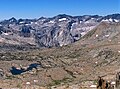
From Mt. Agassiz, with Dusy Basin lower foreground


See also
- List of the major 4000-meter summits of California
References
- ^ a b c d e "Mount McDuffie". Geographic Names Information System. United States Geological Survey, United States Department of the Interior. Retrieved 2021-06-05.
- ^ a b c d "Mount McDuffie, California". Peakbagger.com. Retrieved 2021-06-05.
- ^ a b c d "McDuffie, Mount - 13,282' CA". listsofjohn.com. Retrieved 2021-06-05.
- ^ Alan M. Hedden and David R. Brower, A Climber’s Guide to the High Sierra (1954)
- ISBN 9781594857386, page 277.
- ^ "Climate of the Sierra Nevada". Encyclopædia Britannica.
External links
- Weather forecast: Mount McDuffie
- Mount McDuffie photo: Flickr