
Mount Watson (Washington)
| Mount Watson | |
|---|---|
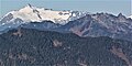
 Northwest aspect, centered | |
| Highest point | |
| Elevation | 6,220 ft (1,896 m)[1] |
| Prominence | 1,300 ft (400 m)[2] |
| Parent peak | Bacon Peak (7,070 ft)[3] |
| Isolation | 2.30 mi (3.70 km)[3] |
| Coordinates | 48°39′20″N 121°34′37″W / 48.6556163°N 121.5768752°W[4] |
| Geography | |
 Mount Watson Location in Washington  Mount Watson Mount Watson (the United States) | |
| Location | Washington, U.S. |
| Parent range | Cascade Range North Cascades Skagit Range |
| Topo map | USGS Bacon Peak |
| Geology | |
| Type of rock | Greenschist |
| Climbing | |
| Easiest route | scrambling[1] |
Mount Watson is a 6,220-foot-elevation (1,900-meter)
Washington state.[4]
Description
Mount Watson is the highest point in the
Climate
Mount Watson is located in the
snowfall onto the Cascades (Orographic lift). As a result, the west side of the North Cascades experiences high precipitation, especially during the winter months in the form of snowfall.[1] Because of maritime influence, snow tends to be wet and heavy, resulting in avalanche danger.[1] Due to its temperate climate and proximity to the Pacific Ocean, areas west of the Cascade Crest very rarely experience temperatures below 0 °F (−18 °C) or above 80 °F (27 °C).[1] During winter months, weather is usually cloudy, but due to high pressure systems over the Pacific Ocean that intensify during summer months, there is often little or no cloud cover during the summer.[1]
Geology
The North Cascades features some of the most rugged topography in the
glacial valleys. Geological events occurring many years ago created the diverse topography and drastic elevation changes over the Cascade Range leading to the various climate differences. These climate differences lead to vegetation variety defining the ecoregions
in this area.
The history of the formation of the Cascade Mountains dates back millions of years ago to the late
During the Pleistocene period dating back over two million years ago, glaciation advancing and retreating repeatedly scoured the landscape leaving deposits of rock debris.[6] The U-shaped cross section of the river valleys is a result of recent glaciation. Uplift and faulting in combination with glaciation have been the dominant processes which have created the tall peaks and deep valleys of the North Cascades area.
Gallery
-
 Mt. Shuksan (left) and Mt. Watson (right) seen from the south at Sauk Mountain
 -
 Northwest aspect of Mount Watson centered.
Glacier Peak distant right. Snowking distant left. -
 Mount Watson (centered) seen from the slopes of Mount Baker. Bacon Peak to left, Baker Lake at bottom of frame.


See also
References
- ^ a b c d e f g Beckey, Fred W. Cascade Alpine Guide, Climbing and High Routes. Seattle, WA: Mountaineers Books, 2008.
- ^ a b "Mount Watson, Washington". Peakbagger.com.
- ^ a b c "Watson, Mount - 6,220' WA". listsofjohn.com. Retrieved 2022-03-07.
- ^ a b c "Mount Watson". Geographic Names Information System. United States Geological Survey, United States Department of the Interior. Retrieved 2022-03-07.
- ^ Henry Landes, A Geographic Dictionary of Washington, (1917), Washington Geological Survey, page 294
- ^ a b c d Kruckeberg, Arthur (1991). The Natural History of Puget Sound Country. University of Washington Press.
External links
- Weather forecast: Mount Watson
Places adjacent to Mount Watson (Washington) | ||||||||||||||||
|---|---|---|---|---|---|---|---|---|---|---|---|---|---|---|---|---|
| ||||||||||||||||