
Nederrijn
| Nederrijn | |
|---|---|
 Nederrijn near Arnhem | |
 Location of the Nederrijn | |
| Location | |
| Country | Netherlands |
| Region | Gelderland |
| Physical characteristics | |
| Source | Pannerdens Kanaal |
| • location | Huissen, Gelderland, Netherlands 51°56′59″N 5°57′7″E / 51.94972°N 5.95194°E |
| • coordinates | 51°56′59″N 5°57′7″E / 51.94972°N 5.95194°E |
| Mouth | Lek |
• location | Wijk bij Duurstede, Utrecht, Netherlands 51°58′11″N 5°21′8″E / 51.96972°N 5.35222°E |
• coordinates | 51°58′11″N 5°21′8″E / 51.96972°N 5.35222°E |
| Length | 50 km (31 mi) |

Nederrijn (Dutch pronunciation: Utrecht.
From the city of Utrecht, the Kromme Rijn forks into the Vecht to the north, and into the Oude Rijn (Utrecht and South Holland) to the west. The first part is channelised and known as the Leidse Rijn (Leiden Rhine). After the railway bridge near Harmelen (municipality Woerden) it's known as the Oude Rijn, flowing westward to the North Sea.
In order to regulate the distribution of drainage between the different branches of the Rhine, several
dams
have been constructed. If the dams were to be closed, there would be little flow in the Nederrijn and most of the water would be drained by the IJssel. As for the Old Rhine, there is a pumping station near the North Sea that protects the river from sea tides and silting.
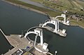
Elst and Amerongen
.
History
In 1530, the Rhine near
St. Jansbeek ("St. John's Brook'), could develop better now that it was closer to the river, and was also more easily defended against Habsburg expansionism into Guelders
.
Gallery
-
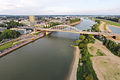 Nederrijn at Arnhem
 -
 Nederrijn near Renkum
 -
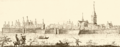
 Plate made byWenzel Hollar1607-1677
 -
 Wageningen 1730


-
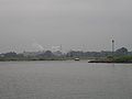
 Panorama near Wageningen
 -
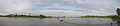
 Nederrijn near Wageningen
 -
 Weir near Amerongen
 -
 The last stretch of the Nederrijn, near Wijk bij Duurstede


See also
- Lower Rhine
- Rhine delta