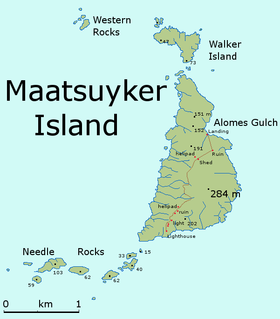
Needle Rocks
Nickname: The Needles | |
|---|---|
 | |
| Geography | |
| Location | South West Tasmania |
| Coordinates | 43°39′45″S 146°15′19″E / 43.66250°S 146.25528°E |
| Archipelago | Maatsuyker Islands Group |
| Adjacent to | Southern Ocean |
| Area | 10.5 ha (26 acres)[1] |
| Administration | |
Australia | |
| State | Tasmania |
| Region | South West |
| Demographics | |
| Population | Unpopulated |
The Needle Rocks, also known as the Needles, are a group of five main
The Maatsuyker Island Lighthouse is located on Maatsuyker Island and illuminates the Needle Rocks.
Fauna

The vegetation is dominated by the pig face, a succulent plant.
The islets are part of the Maatsuyker Island Group
See also
- South East Cape
- South West Cape
- List of islands of Tasmania
References
- ^ a b "Small Southern Islands Conservation Management Statement 2002" (PDF). Tasmania Parks and Wildlife Service. 2002. Archived from the original (PDF) on 22 August 2006. Retrieved 20 July 2006.
- ^ ISBN 0-7246-4816-X
- ^ "Important Bird Area factsheet: Maatsuyker Island Group". Archived from the original on 23 May 2023. Retrieved 23 May 2023.

