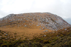
The Cupola (mountain)
| The Cupola | |
|---|---|
 | |
| Highest point | |
| Elevation | 970 m (3,180 ft) |
| Prominence | 650 m (2,130 ft) |
| Parent peak | Frankland Peak |
| Coordinates | 42°56′16″S 146°03′04″E / 42.93778°S 146.05111°E[1] |
| Geography | |
Location in Tasmania | |
| Location | South West Tasmania |
| Parent range | Frankland Range |
| Topo map | Solitary[2] |
The Cupola is a
Redtop Peak is situated to the west of The Cupola.[3]
The mountain's name may derive from cupola, a dome-shaped ornamental structure located on top of a larger roof or dome.
See also
References
- ^ "The Cupola (TAS)". Gazetteer of Australia online. Geoscience Australia, Australian Government.
- ^ Solitary 4224 (Map) (1st ed.). 1:25000. Tasmania: Tasmap. 2001.
- ^ "Map of The Cupola, TAS". Bonzle Digital Atlas of Australia. Retrieved 1 July 2015.

