Louisa Island (Tasmania)
Appearance
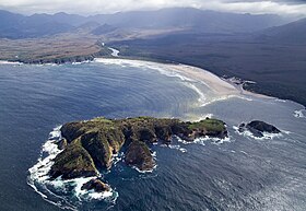
 Louisa Island and Louisa Bay from the air | |
| Geography | |
|---|---|
| Location | South West Tasmania |
| Coordinates | 43°32′02″S 146°21′32″E / 43.534°S 146.359°E |
| Archipelago | Maatsuyker Islands Group |
| Adjacent to | Southern Ocean |
| Area | 23 ha (57 acres)[1] |
| Highest elevation | 80 m (260 ft) |
| Administration | |
Australia | |
| State | Tasmania |
| Region | South West |
| Demographics | |
| Population | Unpopulated |
Louisa Island is an
The island's highest point is 80 metres (260 ft) above sea level and, at low tide, the island is joined to the mainland by a 250 metres (820 ft) sand spit.
Flora and fauna

The central parts of the island are lightly forested with Eucalyptus nitida and Eucalyptus ovata, with an understorey of Leptospermum scoparium and Melaleuca squarrosa. Bracken covers areas subjected to recent fires.
The island is part of the Maatsuyker Island Group
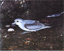
common diving-petrel (1600 pairs), Pacific gull, sooty oystercatcher and pied oystercatcher. Mammals present include the Tasmanian pademelon and long-nosed potoroo. The Tasmanian tree skink is present.[2]
See also
- South East Cape
- South West Cape
- List of islands of Tasmania
References
- ^ a b "Small Southern Islands Conservation Management Statement 2002" (PDF). Tasmania Parks and Wildlife Service. 2002. Archived from the original (PDF) on 22 August 2006. Retrieved 20 July 2006.
- ^ ISBN 0-7246-4816-X
- ^ "Important Bird Area factsheet: Maatsuyker Island Group". Archived from the original on 23 May 2023. Retrieved 23 May 2023.

