
North La Junta, Colorado
North La Junta, Colorado | |
|---|---|
MDT) | |
| ZIP Code[3] | La Junta 81050 |
| Area codes | 970 |
| GNIS feature[2] | North La Junta CDP |
North La Junta is a
Zip Code 81050) serves the area.[3]
History
The North La Junta School is listed on the National Register of Historic Places.
Geography
North La Junta is located just across the Arkansas River from the larger City of La Junta.
The North La Junta CDP has an area of 890 acres (3.602 km2), including 20 acres (0.079 km2) of water.[1]
Demographics
| Year | Pop. | ±% |
|---|---|---|
| 2010 | 512 | — |
| 2020 | 482 | −5.9% |
| Source: United States Census Bureau | ||
The
United States Census 2010
.
See also
References
- ^ a b c d e "State of Colorado Census Designated Places - BAS20 - Data as of January 1, 2020". United States Census Bureau. Retrieved December 26, 2020.
- ^ a b c "U.S. Board on Geographic Names: Domestic Names". United States Geological Survey. Retrieved December 26, 2020.
- ^ a b "Look Up a ZIP Code". United States Postal Service. Retrieved December 26, 2020.
External links
Wikimedia Commons has media related to North La Junta, Colorado.
- La Junta @ Colorado.com
- La Junta @ UncoverColorado.com
- La Junta Tourism
- La Junta Rural Fire Protection District
- Otero County website
Municipalities and communities of Otero County, Colorado, United States | ||
|---|---|---|
| Cities | 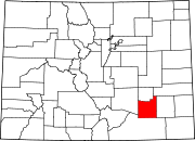 | |
| Towns | ||
| CDPs | ||
| Unincorporated communities | ||
| Ghost town | ||
| Trading posts |
| |
| ||
| International | |
|---|---|
| Other | |