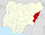
Numan, Nigeria
Numan
Nomweh | |
|---|---|
UTC+1 (WAT) | |
 |
Numan, also known as Nomweh (meaning 'hilltop'), is a town and a Local Government Area in Adamawa State, Nigeria. It is a port town that lies on the confluence of Benue River and Gongola River.[2]
The predominant ethnic group in the town are the Bwatiye (Bachama) people who have a reputation of being unconquered warriors in all their history. The Bwatiye people are led by a First Class King known as the Hama Bachama, who is the paramount ruler of the Bachama Kingdom, whose Voti (palace) is in Numan the administrative seat of the throne while Lamurde has another palace for the King as that is the spiritual or ancestral home of the Bwatiye people. The name of the current King is Homun (King) Dr Daniel Ismaila Shaga OON, who ascended the throne in 2020 . The Queen of the Bachama kingdom is referred to as Mbamto (Queen) and she is Mbamto Rosaline Daniel Ismaila Shaga.They Currently Have Four Children Whose Names Aren’t Identified Yet
The town is the location of Adamawa State Polytechnic.[3]
climate
In Numan, the dry season is oppressively hot and partially cloudy, and the wet season is oppressively hot and overcast. The average annual temperature fluctuates between 15°C - 37°C, rarely falling below 13°C or rising over 41°C.[4][5]
Geography
The Benue and Gongola Rivers meet in Numan LGA, where the average temperature is 34°C. With an average humidity level of 18%, the LGA experiences two distinct seasons: the dry and the rainy.[6]
Economy
In the Numan LGA,
References
- ^ "Numan (Local Government Area, Nigeria) - Population Statistics, Charts, Map and Location". www.citypopulation.de. Retrieved 2024-02-05.
- ^ "Numan Local Government Area". www.finelib.com. Retrieved 2023-08-06.
- ^ "Welcome to Adamawa Polytechnic". Adamawa Polytechnic. Archived from the original on 2009-09-22. Retrieved 2010-03-24.
- ^ "Numan Climate, Weather By Month, Average Temperature (Nigeria) - Weather Spark". weatherspark.com. Retrieved 2023-08-05.
- ^ "Numan, Adamawa, NG Climate Zone, Monthly Averages, Historical Weather Data". tcktcktck.org. Retrieved 2023-08-05.
- ^ a b "Numan Local Government Area". www.manpower.com.ng. Retrieved 2023-08-06.
- ^ "Numan | Hausa-Fulani, Tarok & Gwandara | Britannica". www.britannica.com. Retrieved 2023-08-06.
9°28′1″N 12°1′58″E / 9.46694°N 12.03278°E
Gen. Muhammad Almustapha Musa @ New Motor Park, Numan Nigeria (11 April 2021).

