
Oranienbaum-Wörlitz
Oranienbaum-Wörlitz | |
|---|---|
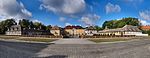
 View over Oranienbaum | |
 Coat of arms | |
Location of Oranienbaum-Wörlitz within Wittenberg district  | |
 Oranienbaum-Wörlitz  Oranienbaum-Wörlitz | |
| Coordinates: 51°47′57″N 12°24′25″E / 51.79917°N 12.40694°E | |
| Country | Germany |
| State | Saxony-Anhalt |
| District | Wittenberg |
| Government | |
| • Mayor (2017–24) | Maik Strömer[1] (CDU) |
| Area | |
| • Total | 115.16 km2 (44.46 sq mi) |
| Elevation | 64 m (210 ft) |
| Population (2022-12-31)[2] | |
| • Total | 8,067 |
| • Density | 70/km2 (180/sq mi) |
| Time zone | UTC+01:00 (CET) |
| • Summer (DST) | UTC+02:00 (CEST) |
| Postal codes | 06785, 06786 |
| Dialling codes | 034904, 034905 |
| Vehicle registration | WB |
| Website | www |
Oranienbaum-Wörlitz is a town in the district of Wittenberg, in Saxony-Anhalt, Germany. It was formed on 1 January 2011 by the merger of the former towns Oranienbaum and Wörlitz and the former municipalities Brandhorst, Gohrau, Griesen, Horstdorf, Kakau, Rehsen, Riesigk and Vockerode.[3] These former municipalities are now Ortschaften (municipal divisions) of the town Oranienbaum-Wörlitz.[4]
-
 Oranienbaum castle
 -
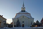 Church Oranienbaum
 -

-
 Wörlitz market square
 -
 Historic Inn „Zum Eichenkranz“ in Wörlitz
 -
 Church of Vockerode


References
- Statistisches Landesamt Sachsen-Anhalt, accessed 8 July 2021.
- Statistisches Landesamt Sachsen-Anhalt. June 2023.
- Statistisches Bundesamt.
- ^ Hauptsatzung der Stadt Oranienbaum-Wörlitz, § 18, 5 February 2020.
Towns and municipalities in the district of Wittenberg | ||
|---|---|---|
 | ||
| International | |
|---|---|
| National | |
| Geographic | |
This Saxony-Anhalt location article is a stub. You can help Wikipedia by expanding it. |