Overmonnow
Overmonnow | |
|---|---|
Ward, suburb | |
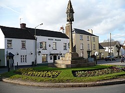
 Restored mediaeval cross and Green Dragon Inn ,St Thomas Square, Overmonnow | |
Nicknames:
| |
| Coordinates: 51°48′31″N 2°43′14″W / 51.80861°N 2.72056°W | |
| Country | Wales |
| County | Monmouthshire |
| Town | Monmouth |
Overmonnow is a suburb of the town of Monmouth, in Wales, which is located to the west of the River Monnow and the Monnow Bridge. It developed in the Middle Ages, when it was protected by a defensive ditch, the Clawdd-du or "Black Dyke", the remains of which are now protected as an ancient monument. In later centuries the area became known as "Little Monmouth" or "Cappers' Town".
History
At the time of the Norman conquest, the area to the east of the River Monnow, and north of the
The area was also known as "Little Monmouth".[5] In the nineteenth century, there was a belief that "Little Monmouth" had at one time been a separate borough from the rest of the town, or "Great Monmouth". This seems to be a legend deriving from a pageant arranged to celebrate the coronation of Queen Victoria in 1838, in which the so-called "mayor of Overmonnow" demanded admittance to the town across Monnow Bridge, and then rode around the town with the (real) mayor of Monmouth.[6] However, the bridge was the scene of annual battles, or "muntlings", between rival gangs from "Up-Town" and "Cappers' Town". These took place on 1 May and 29 May, the youths arming themselves with besoms or "muntles" reinforced with stones. The altercations were banned in 1858.[7]
Substantial development, for both housing and light industry, has taken place in the Overmonnow area since the mid twentieth century. In the
Clawdd-du

The Clawdd-du, or "Black Dyke", was a linear defensive earthwork or

Notable buildings
The
Governance
Overmonnow is a community
Overmonnow is also a county ward which elects a county councillor to sit on Monmouthshire County Council.[17] At the May 2022 elections the seat was won by Steven Garratt for Welsh Labour.[18]
References
- ISBN 1-904396-01-1.
- ^ Kissack, Keith (1974). Mediaeval Monmouth. The Monmouth Historical and Educational Trust. p. 24.
- ^ Kelly's Directory 1901: Monmouth Archived 29 October 2016 at the Wayback Machine. Accessed 28 January 2012
- ^ a b "History of St Thomas the Martyr". Monmouth Parishes. Retrieved 9 December 2011.
- ^ Kissack, Mediaeval Monmouth, p.33
- ^ Kissack, Mediaeval Monmouth, p.57
- ISBN 1-873827-40-7, p.262
- ^ ONS Neighbourhood Statistics: Overmonnow Ward. Accessed 28 January 2012
- ^ Monmouthshire County Council: Cllr. S White. Accessed 28 January 2012
- ISBN 0-7509-0415-1, p.3
- ^ British Listed Buildings: Clawdd-du Bridge. Accessed 28 January 2012
- ^ ISBN 0-14-071053-1, p.410
- ^ Kissack, Monmouth and its Buildings, p.60
- ^ "Councillors". Monmouth Town Council. Retrieved 3 January 2019.
- ^ "Independents cause a stir in council elections". Monmouthshire Beacon. 10 May 2017. Retrieved 3 January 2019.
- ^ "By-election win for Welsh Conservatives' Sue White". Monmouthshire Beacon. 20 April 2018. Retrieved 3 January 2019.
- ^ The County of Monmouthshire (Electoral Changes) Order 2002. Statutory Instruments. 6 December 2002. Retrieved 3 January 2019.
{{cite book}}:|website=ignored (help) - ^ "Election Results for Overmonnow". Monmouthshire Council. 5 May 2022. Retrieved 16 July 2022.
