
Pacaya
| Pacaya | |
|---|---|
 An eruption of Pacaya in 1976 | |
| Highest point | |
| Elevation | 2,552 m (8,373 ft)[1] |
| Prominence | 1,077 m (3,533 ft) |
| Listing | List of volcanoes in Guatemala |
| Coordinates | 14°22′51″N 90°36′04″W / 14.38083°N 90.60111°W[1] |
| Geography | |
| Geology | |
| Age of rock | 0-23,000 |
| Mountain type | Complex volcano |
| Volcanic arc/belt | Central America Volcanic Arc |
| Last eruption | February 14, 2021 - ongoing |

Pacaya is an active
Pacaya is a popular tourist attraction. It is even the home to the popular Guatemala Impact Marathon which pioneered the use of a running route across the lava field created by the 2010 eruption and supports the local communities through runners endeavouring to complete the challenge.
Villagers near Pacaya ignored an evacuation request as the volcano threw ash into the air in March 2021.[6]
Geological history
The Pacaya volcano is a part of the
After the last caldera-forming eruption 23,000 years ago, several smaller vents within and around the caldera have seen eruptive activity. Pacaya is the largest post-caldera volcano, and has been one of Central America's most active volcanoes over the last 500 years. It has erupted at least 23 times since the
About 1,100 years ago the volcano's edifice collapsed, causing a huge landslide. Deposits from the landslide travelled about 25 kilometres (16 mi) from the volcano down to the Pacific coastal plain. The landslide left a large crater, within which the current active cone has grown. The presence of a magma chamber at shallow depths beneath Pacaya means that distortion of the cone leading to instability and future landslides remains a hazard to the surrounding areas.[1]
Recent eruptions

With its almost continuous activity, the volcano has been a popular location for
In 1998, several explosive eruptions emitted lava, debris and ash columns with a height of 1,500 m (4,900 ft) to 5,000 m (16,000 ft). The ash fall affected nearby cities including Guatemala city and La Aurora International Airport.[8]
During 2006, a slight increase in Pacaya's volcanic activity brought about the creation of several lava rivers that slowly flowed down its slope. Word about these phenomena spread, and local tourism increased significantly.[citation needed]
May 2010 eruption
On May 27, 2010, the Pacaya volcano erupted, followed by several tremors. At approximately 20:00 hours there was a strong eruption ejecting debris and ash columns up to 1,500 metres (4,900 ft). Ash rained down in many Guatemalan cities to the northwest of the volcano, including Guatemala City.[10] The volcanic ash fall pelted Guatemala City, and the international airport, La Aurora. The National Coordinator for Disaster Reduction (CONRED) declared a red alert for the communities near the volcano and recommended the evacuation of some of them. Noti7 reporter Anibal Archila, one of the first to cover the event, was reportedly killed by volcanic debris.[11]
President
See also
Pacaya.
References
- ^ a b c d e f g "Pacaya". Global Volcanism Program. Smithsonian Institution. Retrieved 2020-08-05.
- ^ "Guatemala Impact Marathon". Impact Marathon.
- ^ a b Google Earth
- ^ Servicio de Informacion Municipal, Departmento de Escuintla (in Spanish), retrieved 2010-01-14
- ^ "Volcano Boarding in Guatemala". Sand-boarding.com. Retrieved 8 August 2022.
- ^ "Evacuation request ignored at Guatemala's Pacaya volcano". ABC News. March 4, 2021. Retrieved March 4, 2021.
- Bibcode:2001AGUFM.V41A0976R
- ^ INSIVUMEH. "Volcán de Pacaya". INSIVUMEH.
- ^ Guatemala Volcanoes
- ^ "Pacaya Volcano (Guatemala)". Volcano Discovery. May 28, 2010. Retrieved May 30, 2010.
- ^ "Hundreds flee Guatemala volcano". BBC News. May 28, 2010. Retrieved May 31, 2010.
- ^ Campbell, Robert (May 29, 2010). "Guatemala girds for first Pacific storm of season". Reuters. Archived from the original on June 1, 2010. Retrieved May 29, 2010.
{{cite web}}: CS1 maint: unfit URL (link)
External links
- Pacaya images and information from VolcanoWorld
- BBC News article about an eruption in 2000
- Pacaya 1992 auf Vulkanfaszination
Image gallery
- Pacaya
-
 Runners at the Impact Marathon race on Pacaya
 -
 Volcán Pacaya (2005).
 -
 Tourists climbing Pacaya (2004).
 -
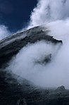 Noxious gas cloud (2002).
 -
 Pacaya after a strombolian eruption (1992).
 -
 Strombolian eruption of Pacaya (1992).
 -
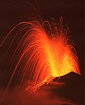 Strombolian eruption of Pacaya (1992).
 -
 Lava flow (2006).


| Guatemala |  | |
|---|---|---|
| El Salvador | ||
| Nicaragua | ||
| Costa Rica |
| |
| Panama |
| |
Note: volcanoes are ordered from north-west to south-east. | ||
| International | |
|---|---|
| Geographic | |