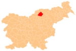
Pameče
Pameče | |
|---|---|
Slovenj Gradec | |
| Area | |
| • Total | 15.85 km2 (6.12 sq mi) |
| Elevation | 406.4 m (1,333.3 ft) |
| Population (2002) | |
| • Total | 1,278 |
| [1] | |
Pameče (pronounced Styria. The entire municipality is now included in the Carinthia Statistical Region.[2]
Mass graves
Pameče is the site of two known mass graves associated with the Second World War. The Fuks 1 and 2 mass graves (Slovene: Grobišče Fuks 1, 2) are located at the Hribernik farm (at Pameče no. 183), 5 meters (16 ft) west and 20 meters (66 ft) south of the house, respectively. They contain the remains of an unidentified number of victims, believed to be mostly Croatians.[3][4]
Church
The
Saint James (Slovene: sveti Jakob) and belongs to the Roman Catholic Archdiocese of Maribor. It was first mentioned in written documents dating to 1488. The current building dates to 1868.[5] A second church on a hill north of the settlement is dedicated to Saint Anne and was built in 1530.[6]
References
- ^ Statistical Office of the Republic of Slovenia
- ^ Slovenj Gradec municipal site
- ^ Ferenc, Mitja (December 2009). "Grobišče Fuks 1". Geopedia (in Slovenian). Ljubljana: Služba za vojna grobišča, Ministrstvo za delo, družino in socialne zadeve. Retrieved November 29, 2023.
- ^ Ferenc, Mitja (December 2009). "Grobišče Fuks 2". Geopedia (in Slovenian). Ljubljana: Služba za vojna grobišča, Ministrstvo za delo, družino in socialne zadeve. Retrieved November 29, 2023.
- ^ Slovenian Ministry of Culture register of national heritage reference number ešd 3217
- ^ Slovenian Ministry of Culture register of national heritage reference number ešd 3218

