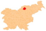
Zgornji Razbor
Zgornji Razbor | |
|---|---|
Slovenj Gradec | |
| Area | |
| • Total | 17.97 km2 (6.94 sq mi) |
| Elevation | 910.2 m (2,986.2 ft) |
| Population (2002) | |
| • Total | 113 |
| [1] | |
Zgornji Razbor (pronounced Styria. The entire municipality is now included in the Carinthia Statistical Region.[3]
The parish church in the settlement is dedicated to the Prophet Daniel and belongs to the Roman Catholic Archdiocese of Maribor. It dates to the late 16th century.[4]
References
- ^ Statistical Office of the Republic of Slovenia Archived November 18, 2008, at the Wayback Machine
- ^ Leksikon občin kraljestev in dežel zastopanih v državnem zboru, vol. 4: Štajersko. Vienna: C. Kr. Dvorna in Državna Tiskarna. 1904. p. 266.
- ^ Slovenj Gradec municipal site
- ^ Slovenian Ministry of Culture register of national heritage Archived July 12, 2010, at the Wayback Machine reference number ešd 3312

