
Paston Way
| The Paston Way | |
|---|---|
.JPG) Paston Way route marker | |
| Length | 20 mi (32 km) |
| Location | Northeastern Norfolk |
| Designation | Recreational walk |
| Trailheads | North Walsham 52°49′18″N 1°23′13″E / 52.8216°N 1.3869°E Cromer 52°55′53″N 1°18′02″E / 52.9314°N 1.3006°E |
| Use | Walking |
| Season | All year Round |
| Sights | Route takes in 16 churches and 16 villages and towns. |
The Paston Way is a footpath. It is entirely within the English county of Norfolk in the United Kingdom.[1] The footpath is twenty miles in length, the portals to the path are Cromer at its northwestern end and North Walsham at it southeastern end.
The Designation
The Paston way takes its name from the
Description of the Route
Section 1

Starting at the southeastern end, the path begins at the Parish Church of
Section 2
It is worth a visit to see the roof inside Knapton Church with its ornate Double hammer beam roof.[2]
From Knapton the path heads south east across several open fields towards the village of Edingthorpe. The approach to the village is up a gently sloping farm track towards Edingthorpe Parish church which is called All Saints.
Section 3
The 'way' continues on from All Saints northwest towards the coast and the village of Bacton. A little way along this section a detour can be made at church farm. Take the path north to Paston. Visit the parish church of St Margaret's. inside can be seen the impressive Paston Monuments to the family that gave the trail its name. Retrace your footsteps to church farm and then continue on down the winding lane to Bacton Church.
Section 4

Bacton church is called St Andrews which is approached via an attractive avenue of trees which is in sharp contrast to the Bacton Gas Interconnector Terminal that dominates the horizon behind.[3] The ‘Way’ passes through the church yard and out across open farm land towards the North Sea coast at the western end of the village. The next three miles take a route along the beach passing by the Gas terminal. At Mundesley the rout follows the main coast road to the northern tip of the village and to All Saints Church.
Section 5
.JPG)
The route now heads back inland towards the next village of Gimingham this part of the trail passes through the valley of the River Mun. The countryside along this section is pleasant and very peaceful. One usual sight to the north of the ‘Trail’ is the giant white sphere which can be glimpsed occasionally. This is the Trimingham Early warning station which is in fact part of RAF Neatishead. The path enters the village of Gimingham past the rebuilt old corn watermill and the preserved steam engine. Like Mundesley, Gimingham parish church is called All Saints. It is south down the main street from the engine. From this point there is an optional tour which takes in the villages of Trunch, Swafield, Bradfield and then back on itself to Trimingham and its unusually named church St John the Baptist's Head.[4]
Section 6
From Gimingham the path heads towards Southrepps via a lane known as Jack o' Lantern's Lane. The lane is reputed to be the territory of the Lantern man who lures all travellers to their doom. The parish church of Southrepps is called St James. Note the corbels and gargoyles high up on this church. At this point if you wish to visit the church and village, you must walk south into the village and then retrace your footsteps back to rejoin the Paston Way.
Section 7
From Southrepps the path takes a route to the south of Frogshall Hamlet along the ancient farm lanes towards the coastal village of Overstrand. There are two detour made on this section the first is to the village of Northrepps.
Detour A
Northrepps parish church is called St Mary the Virgin, retrace your footstep back to Paston Way or pass through the village turning east over Hungry Hill and take the second detour.
Detour B
Section 8

Return to Hungry Hill via Sandy lane and the Shrieking pit which legend has it was the scene of the demise of a young maiden lured to her death by evil spirits. Then the path moves on to
Section 9
The last section of Paston way is between Overstrand and
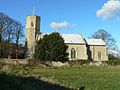
Gallery of Churches
-
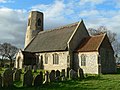
 Saint Nicholas, North Walsham
 -
 Saint Peter and Saint Paul, Knapton
 -
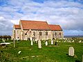
 All Saints, Edingthorpe
 -
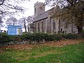
 Saint Margaret, Paston
 -
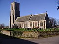
 Saint Andrew, Bacton
 -
 All Saints, Mundesley
 -
 All Saints, Gimingham
 -
 Saint Botolph, Trunch
 -
 Saint Nicholas, Swafield
 -
 Saint Giles, Bradfield
 -
 Saint John the Baptist's Head, Trimingham
 -
 Saint James, Southrepps
 -
 Saint Michael and All Angels, Sidestrand
 -
 Saint Mary the Virgin, Northrepps
 -
 Saint Martin, Overstrand
 -
 Saint Peter and Saint Paul, Cromer


.JPG)
.JPG)


.JPG)

.JPG)
.JPG)

Gallery of Route
-
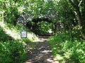 Knapton Cutting
 -
 Knapton Cutting
 -
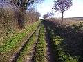 Between Northrepps and Southrepps
 -
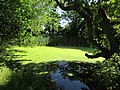 The Shrieking Pit on Sandy Lane, Hungary Hill

.JPG)
.JPG)

External links
References
- ISBN 0-319-21727-2
- ISBN 0-300-09607-0
- ISBN 0-319-21888-0.
- ISBN 0-300-09607-0
- ISBN 0-946148-56-2