Pattani province
This article needs additional citations for verification. (December 2020) |
Pattani
ปัตตานี | ||
|---|---|---|
Rumi) | ||
| • Chinese | 北大年 (Simplified) | |
 Pattani Grand Mosque | ||
|
Postal code 94xxx | ||
| Calling code | 073 | |
| ISO 3166 code | TH-94 | |
| Website | www | |
Pattani (
Geography
Pattani is on the
National parks
There are two national parks, along with three other national parks, make up
- Budo–Su-ngai Padi National Park, 341 km2 (132 sq mi)[6]: 96
- Namtok Sai Khao National Park, 70 km2 (27 sq mi)[6]: 110
Toponymy
The name Pattani is the
History
Historically, Pattani province was the centre of the
Demographics
Pattani is one of the four provinces of Thailand where the majority of the population are Muslim, the others being
Symbols
The
The provincial flower is the Chinese hibiscus (]
Administrative divisions
Provincial government
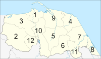
Pattani is divided into 12 districts (
| Map | Number | Name | Thai | Jawi | Malay |
|---|---|---|---|---|---|

|
1 | Mueang Pattani |
เมืองปัตตานี | فطاني | Patani/Fathoni |
| 2 | Khok Pho |
โคกโพธิ์ | كوكفور | Khuppur | |
| 3 | Nong Chik |
หนองจิก | نوڠجيك | Nungjik | |
| 4 | Panare |
ปะนาเระ | فناريق | Penarik | |
| 5 | Mayo | มายอ | مايو | Mayu | |
| 6 | Thung Yang Daeng |
ทุ่งยางแดง | طوڠيڠديڠ | Thungyangdeng | |
| 7 | Sai Buri |
สายบุรี | سليندوڠ بايو ، تلوبن | Selindung Bayu, Teluban | |
| 8 | Mai Kaen |
ไม้แก่น | مايكين | Maikaen | |
| 9 | Yaring |
ยะหริ่ง | جمبو | Jambu | |
| 10 | Yarang |
ยะรัง | ياليمو | Yalimo | |
| 11 | Kapho |
กะพ้อ | كأفو | Kapor | |
| 12 | Mae Lan |
แม่ลาน | ميلان | Melan |
Local government

As of 26 November 2019 there are:
Economy
Six of Pattani's districts lie on the shore of the Gulf of Thailand. The number of fisheries workers in Pattani exceeds 80,000 as of 2019[update].[12] Pattani is the only province in Thailand where the agriculture ministry prohibits trawlers and destructive fishing nets within four nautical miles of the shoreline. Local fish stocks have rebounded as a result.[12]
Despite having many interesting places. But Pattani is the least visited province in the country according to data from Ministry of Tourism and Sports in 2018, the number of tourists is only 20,000–30,000 people, mostly Thai people.[13]
Transport
The Royal Thai Air Force's
Human achievement index 2022
| Health | Education | Employment | Income |
| 15 | 77 | 33 | 76 |
| Housing | Family | Transport | Participation |

|
 |

|
|
| 45 | 11 | 7 | 40 |
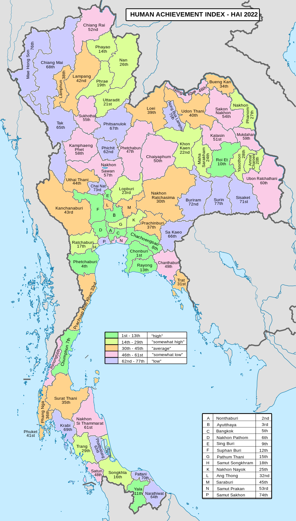
| Province Pattani, with an HAI 2022 value of 0.6149 is "low", occupies place 70 in the ranking. | |||
Since 2003, United Nations Development Programme (UNDP) in Thailand has tracked progress on human development at sub-national level using the Human achievement index (HAI), a composite index covering all the eight key areas of human development. National Economic and Social Development Board (NESDB) has taken over this task since 2017.[3]
| Rank | Classification |
| 1 - 13 | "high" |
| 14 - 29 | "somewhat high" |
| 30 - 45 | "average" |
| 46 - 61 | "somewhat low" |
| 62 - 77 | "low" |
| Map with provinces and HAI 2022 rankings |

|
Military rule
As of 2018[update], the provisions of Thailand's Internal Security Act remain imposed on Mae Lan District. Internal security restrictions, maintained by Thailand's Internal Security Operations Command can result in curfews, prohibited entry, or prohibited transport of goods. It is considered one step below the imposition of full martial law.[14]
Places of interest

Pattani has named as the land of three religions (Buddhism, Islam,
- Wat Rat Burana (Thai: วัดราษฎร์บูรณะ), also known as Wat Chang Hai (Thai: วัดช้างให้), an ancient Thai Buddhist temple older than 300 years, a legendary monk Luang Pu Thuat was once the abbot of this place.
- Leng Chu Kiang Shrine (Thai: ศาลเจ้าเล่งจูเกียง) Chinese shrine of Lim Ko Niao (younger sister of Lin Daoqian).
- Krue Se Mosque (Thai: มัสยิดกรือเซะ) Regarded as one of the more famous mosques with the oldest history.[15]
See also
References
- ISBN 978-974-680-368-7. Retrieved 17 January 2016, Data has been supplied by Land Development Department, Ministry of Agriculture and Cooperatives, at Wayback Machine.]
{{cite report}}: CS1 maint: postscript (link)[dead link - ^ a b "รายงานสถิติจำนวนประชากรและบ้านประจำปี พ.ศ.2561" [Statistics, population and house statistics for the year 2018]. Registration Office Department of the Interior, Ministry of the Interior (in Thai). 31 December 2018. Retrieved 20 June 2019.
- ^ a b "ข้อมูลสถิติดัชนีความก้าวหน้าของคน ปี 2565 (PDF)" [Human Achievement Index Databook year 2022 (PDF)]. Office of the National Economic and Social Development Council (NESDC) (in Thai). Retrieved 12 March 2024, page 45
{{cite web}}: CS1 maint: postscript (link) - ISSN 1686-0799. Retrieved 22 January 2020.
- ^ "ตารางที่ 2 พี้นที่ป่าไม้ แยกรายจังหวัด พ.ศ.2562" [Table 2 Forest area Separate province year 2019]. Royal Forest Department (in Thai). 2019. Retrieved 6 April 2021, information, Forest statistics Year 2019
{{cite web}}: CS1 maint: postscript (link) - ^ a b "ข้อมูลพื้นที่อุทยานแห่งชาติ ที่ประกาศในราชกิจจานุบกษา 133 แห่ง" [National Park Area Information published in the 133 Government Gazettes]. Department of National Parks, Wildlife and Plant Conservation (in Thai). December 2020. Retrieved 1 November 2022.
- JSTOR 41491922.
- ^ "{ms} Sejarah Malaysia - Asal Usul nama Sungai Petani". Sejarahmalaysia.pnm.my. Archived from the original on 2013-06-03. Retrieved 2012-08-24.
- ^ "A Brief Introduction to the Malay Kingdom of Patani". Islamic Human Rights Commission. 21 December 2004.
- ^ Pattani : Selamat Datang Ke Pattani (PDF). Songkhla: IQ Media. 2018. p. 16.
- ^ "Number of local government organizations by province". dla.go.th. Department of Local Administration (DLA). 26 November 2019. Retrieved 10 December 2019.
31 Pattani: 1 PAO, 2 Town mun., 15 Subdistrict mun., 96 SAO.
- ^ a b Kongrut, Anchalee (2 September 2019). "From Pattani seas to Bangkok plates". Bangkok Post. Retrieved 7 September 2019.
- ^ Laohavichai, Nakan (2019-01-11). "เมืองที่ไม่มีใครแล" [Town that nobody cares]. Posttoday (in Thai). Retrieved 2020-01-01.
- ^ Raksaseri, Kornchanok (8 January 2018). "Isoc power boost 'not political'". Bangkok Post. Retrieved 8 January 2018.
- ^ Manager Online(in Thai). 2016-03-07. Retrieved 2019-01-15.
External links
 Pattani travel guide from Wikivoyage
- Pattani province website (Thai)
- Tourism Authority of Thailand (TAT): Pattani
- Pattani Erupts Archived February 13, 2009, at the Wayback Machine
- Thailand Islamic Insurgency
- Muslim rebels light fuse in Thailand
