
Pedrógão Grande
Pedrógão Grande | |
|---|---|
 | |
|
UTC±00:00 (WET) | |
| • Summer (DST) | UTC+01:00 (WEST) |
| Local holiday | July 24 |
| Website | http://www.cm-pedrogaogrande.pt |
Pedrógão Grande (Portuguese pronunciation:
The town itself has fewer than 2,000 inhabitants, with the remaining population living in several small villages surrounded by forests. The town center contains historical provincial gentry housing. The earliest town charter dates to 1206, when rights to hold a market were conceded by Afonso Pedro, natural son of Afonso II of Portugal; however, the current municipality was established only in 1898. The present mayor is Valdemar Gomes Fernandes Alves, an independent elected in 2013 by the Social Democratic Party. The municipal holiday is July 24.
The municipality is located in a large region of granite and shale in the basin of the
.The municipality and surrounding region has suffered in the 2017 Portugal wildfires, leaving 64 dead, over 250 injured and forty evacuated villages.[3]
-
 Old bridge (Filipina)
 -
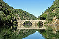 Old bridge (Filipina)
 -
 Bridge over Zêzere river (IC8)
 -


Parishes
Administratively, the municipality is divided into three civil parishes (
- Graça
- Pedrógão Grande
- Vila Facaia
See also
References
- ^ Instituto Nacional de Estatística
- ^ "Áreas das freguesias, concelhos, distritos e país". Archived from the original on 2018-11-05. Retrieved 2018-11-05.
- ^ Sapo 24. "Pedrógão Grande: Quarenta aldeias evacuadas" (in Portuguese). Retrieved 23 June 2017.
{{cite web}}: CS1 maint: numeric names: authors list (link) - ^ Diário da República. "Law nr. 11-A/2013, page 552 90" (pdf) (in Portuguese). Retrieved 29 July 2014.
| Authority control databases: Geographic |
|---|
This Leiria location article is a stub. You can help Wikipedia by expanding it. |