
Pierrepont, Meurthe-et-Moselle
Pierrepont | |
|---|---|
 The town hall in Pierrepont | |
 Coat of arms | |
Location of Pierrepont  | |
Briey | |
| Canton | Mont-Saint-Martin |
| Intercommunality | CC Terre Lorraine du Longuyonnais |
| Government | |
| • Mayor (2020–2026) | James Moineaux[1] |
| Area 1 | 7.02 km2 (2.71 sq mi) |
| Population (2021)[2] | 839 |
| • Density | 120/km2 (310/sq mi) |
| Time zone | UTC+01:00 (CET) |
| • Summer (DST) | UTC+02:00 (CEST) |
| INSEE/Postal code | /54620 |
| Elevation | 227–336 m (745–1,102 ft) (avg. 241 m or 791 ft) |
| 1 French Land Register data, which excludes lakes, ponds, glaciers > 1 km2 (0.386 sq mi or 247 acres) and river estuaries. | |
Pierrepont (French pronunciation: [pjɛʁpɔ̃] ⓘ) is a commune in the Meurthe-et-Moselle department in north-eastern France.
History
During the
headquarter of the Sturm-Bataillon Nr. 5 (Rohr)
, in Pierrepont has been the hospital and the cemetery.
On the German soldiers cemetery, the dead of the Battalion were mostly buried. The monument, in the shape of a lion guarding the dead, has already been set up during the war and then not eliminated.[3]
-
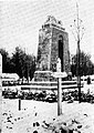 Memorial

See also
Notes
- ^ "Répertoire national des élus: les maires". data.gouv.fr, Plateforme ouverte des données publiques françaises (in French). 2 December 2020.
- ^ "Populations légales 2021". The National Institute of Statistics and Economic Studies. 28 December 2023.
- Zeulenroda1939
Wikimedia Commons has media related to Pierrepont (Meurthe-et-Moselle).
| Authority control databases: National |
|---|
This Meurthe-et-Moselle geographical article is a stub. You can help Wikipedia by expanding it. |