
Villers-lès-Nancy
Villers-lès-Nancy | |
|---|---|
 The Remicourt chateau in Villers-lès-Nancy | |
 Coat of arms | |
Location of Villers-lès-Nancy  | |
 Villers-lès-Nancy  Villers-lès-Nancy | |
| Coordinates: 48°40′23″N 6°09′17″E / 48.6731°N 6.1547°E | |
| Country | France |
| Region | Grand Est |
| Department | Meurthe-et-Moselle |
| Arrondissement | Nancy |
| Canton | Laxou |
| Intercommunality | Métropole du Grand Nancy |
| Government | |
| • Mayor (2020–2026) | François Werner[1] |
| Area 1 | 9.95 km2 (3.84 sq mi) |
| Population (2021)[2] | 14,761 |
| • Density | 1,500/km2 (3,800/sq mi) |
| Time zone | UTC+01:00 (CET) |
| • Summer (DST) | UTC+02:00 (CEST) |
| INSEE/Postal code | 54578 /54600 |
| Elevation | 224–381 m (735–1,250 ft) (avg. 285 m or 935 ft) |
| 1 French Land Register data, which excludes lakes, ponds, glaciers > 1 km2 (0.386 sq mi or 247 acres) and river estuaries. | |
Villers-lès-Nancy (French pronunciation: [vilɛʁ lɛ nɑ̃si], literally Villers near Nancy) is a commune in the Meurthe-et-Moselle department in north-eastern France.
Inhabitants are known as Villarois.
Geography
Villers-lès-Nancy is a suburb on the southwest of Nancy. The commune goes from Nancy to the Haye forest.
It is composed of three quarters :
- the Mairie-Placieux quarter, which is the closest to Nancy,
- the Botanique-Village quarter, which goes from the Jardin botanique du Montet to the Brabois plateau,
- the Clairlieu quarter, in a large opening of the Haye forest, beyond the A 33.
The neighbourhood communes of the Grand Nancy are : Laxou, Nancy and Vandœuvre-lès-Nancy.
Population
Graphs are unavailable due to technical issues. There is more info on Phabricator and on MediaWiki.org. |
| Year | Pop. | ±% p.a. |
|---|---|---|
| 1968 | 7,811 | — |
| 1975 | 14,084 | +8.79% |
| 1982 | 16,120 | +1.95% |
| 1990 | 16,515 | +0.30% |
| 1999 | 15,694 | −0.56% |
| 2007 | 15,115 | −0.47% |
| 2012 | 14,386 | −0.98% |
| 2017 | 14,415 | +0.04% |
| Source: INSEE[3] | ||
Points of interest
-
 Church of Saint-Fiacre.
 -
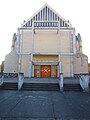 Church of Sainte-Thérèse-de-l'enfant-Jésus.
 -
 Church of Saint-Bernard (Clairlieu).
 -
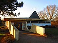
 Orthodox chapel of the Gauls.
 -
 Major Seminar of l’Asnée.
 -
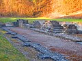 Ancient Cistercian abbey of the place-dit Clairlieu.


Mayors
- François Villard, 1791
- Jean Claude Charbonnier, 1791
- François Villard, 1792
- Dieudonné Pierson, 1794
- François Villard, 1794
- Dieudonné Pierson, 1799
- François Houard, 1816
- Lefebvre, 1821
- Jean Claude Clement, 1831
- François Pierson, 1848
- Amédée Lefebre de Monjoie, 1871
- Hubert Simon, 1875
- Louis Valet, 1888
- Anatole de Scitivaux de Greische, 1900
- Louis Porry, 1912
- Louis Pierson de Brabois, 1915
- Charles Oudille, 1919
- Hyppolyte Briot, 1927
- Albert Cattenoz, 1935
- Martial Mourot, 1942
- Maurice Andre, 1944
- Raymond Villaume, 1945
- James Moisson, 1947
- Paul Muller, 1965
- Jean Bernardaux, 1980
- Pascal Jacquemin, 2001
Twin towns
 Oerlinghausen, Germany, 1988
Events
- Fête des Vendanges, a wine harvest celebration that occurs at the end of August/beginning of September
- Faites du solaire, another feast that occurs each year in October
See also
References
- ^ "Répertoire national des élus: les maires". data.gouv.fr, Plateforme ouverte des données publiques françaises (in French). 2 December 2020.
- ^ "Populations légales 2021". The National Institute of Statistics and Economic Studies. 28 December 2023.
- ^ Population en historique depuis 1968, INSEE
External links
Wikimedia Commons has media related to Villers-lès-Nancy.
| International | |
|---|---|
| National | |
This Meurthe-et-Moselle geographical article is a stub. You can help Wikipedia by expanding it. |