
Pilot Butte (Oregon)
| Pilot Butte | |
|---|---|
 | |
| Highest point | |
| Elevation | 4,142 ft (1,262 m) NAVD 88[1] |
| Prominence | 480 ft (150 m) |
| Coordinates | 44°03′38″N 121°17′00″W / 44.060540764°N 121.283235542°W[1] |
| Geography | |
 Pilot Butte  Pilot Butte Pilot Butte (Oregon) | |
| Parent range | Cascades |
| Topo map | USGS Bend |
| Geology | |
| Age of rock | Less than 780,000 years[2] |
| Mountain type | Cinder cone |
| Volcanic arc | Cascade Volcanic Arc |
| Climbing | |
| Easiest route | Road |
Pilot Butte is a lava dome that was created from an
.The 114.22-acre (46.22-hectare) Pilot Butte State Scenic Viewpoint, presented as a gift to the State of Oregon in 1928, is a Bend icon. Pilot Butte itself is a popular hiking destination with two trails to the summit, each gaining about 490 feet (150 m) in elevation. There is also a 1.8-mile (2.9 km) trail around the base of the butte. A scenic road also winds up and around the cone. In 2018, the park was the most visited
Geography
Pilot Butte is located in
Geology and eruptive history
Pilot Butte is a Pleistocene cinder cone volcano.[7][8] During the late Pleistocene, eruptions at Newberry Volcano produced voluminous basalt lava flows that extended into the area now occupied by Bend and Redmond. About 78,000 years ago, similar eruptive activity formed lava flows that surrounded Pilot Butte and filled the Deschutes riverbed, altering the course of the river by redirecting it to form a new channel to the west. The interior of these lava flows can be explored at Lava River Cave.[7]
Lava deposited by Pilot Butte has an
Pilot Butte is extinct.[12] Its exact age is unknown,[9] though one study dated the volcano to about 188,000 ± 42,000 years ago.[4] The volcanic rock has normal magnetic polarity, suggesting that it was laid down after the most recent geomagnetic reversal about 780,000 years ago.[9][10] The butte's light-colored soil contains some ash from the eruption of Mount Mazama (which formed Crater Lake).[12]
Ecology
The most common tree on Pilot Butte is
History
Pilot Butte has been a
Pilot Butte was named in 1851 by Thomas Clark, leader of the first party of European settlers to camp on the future site of Bend. The Clark wagon train approached the area from the east after recovering from the Clark massacre.
In 1983, a drive-in hamburger restaurant called Pilot Butte Drive-In was opened next to the butte on Greenwood Avenue. It remained open until 2020, when it was closed in response to COVID-19 lockdowns.[14] The property was sold and later reopened as a pizza, beer, and poker establishment,[15] known as the Pilot Butte Taproom or the Bend Poker Room.[16]
A National Geodetic Survey station sits at the top of the volcano about 1 mile (1.6 km) east of Bend. It sits in the center of a
Recreation
A road extends to the top of the summit, which is accessible by car[5] during daylight hours, although it closes during the winter season.[12] Several hiking trails traverse the volcano, all reaching the summit. Other volcanoes in the Cascades can be seen from Pilot Butte's summit, including the Three Sisters, Black Butte, Mount Jefferson, and Mount Hood.[8] In 2010, a 1.8-mile (2.9 km) trail was constructed around the base of the butte.[17]
Pilot Butte State Scenic Viewpoint includes more than 7 miles (11 km) of trails on the volcano.
Gallery
-
 Viewed from suburbia (2003)
 -
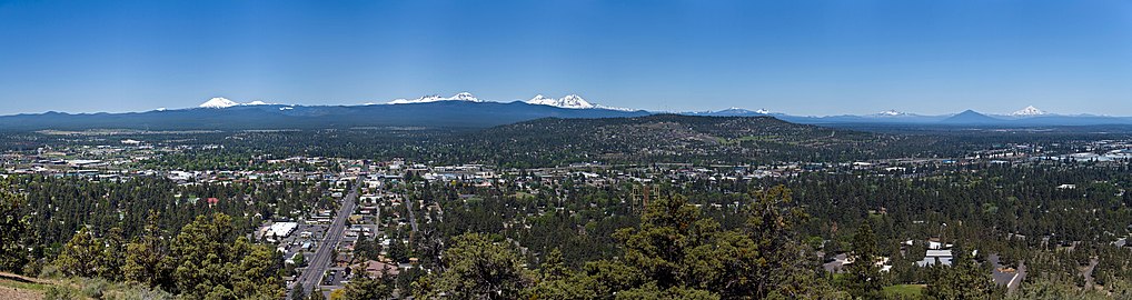 Panoramic view of Bend from the peak (2008)
 -
 Butte ecology (2014)
 -
 The closed Pilot Butte Drive-In (2022)


_-_09.JPG)

References
- ^ a b c d "Pilot Butte". NGS Data Sheet. National Geodetic Survey, National Oceanic and Atmospheric Administration, United States Department of Commerce. Retrieved April 2, 2008.
- ^ "USGS Geologic Investigations Series Map I-2683, pamphlet" (PDF). U.S. Department of the Interior and U.S. Geological Survey. 2004. Retrieved October 28, 2018.
- ^ "July 4th Fireworks Spectacular". Bend Oregon Visitor Bureau for Hotels, Lodging, or Restaurants. Retrieved January 12, 2013.
- ^ a b Jensen, Donnelly-Nolan & Mckay 2009, p. 76.
- ^ a b c McArthur & McArthur 1984, p. 669.
- ^ "Pilot Butte". Geographic Names Information System. United States Geological Survey, United States Department of the Interior. Retrieved April 29, 2023.
- ^ a b Harris 2005, p. 169.
- ^ a b "Description: Pilot Butte Cinder Cone, Oregon". United States Geological Survey. January 25, 2007. Archived from the original on June 11, 2011. Retrieved April 29, 2023.
- ^ a b c d Sherrod et al. 2004, p. 11.
- ^ a b c Sherrod et al. 2004, p. 22.
- ^ a b c Sherrod et al. 2004, p. 38.
- ^ a b c d e "Pilot Butte State Scenic Viewpoint" (PDF). Oregon State Parks. Oregon Parks and Recreation Department. Retrieved April 30, 2023.
- ^ "Pilot Butte Is Presented To State For Public Park". Bend Bulletin. October 1, 1928. Archived from the original on August 2, 2017. Retrieved June 28, 2021.
- ^ Bohanan, A. (April 24, 2020). "Pilot Butte Drive-In closes; beloved burger joint future in doubt". Central Oregon Daily. Retrieved July 27, 2022.
- ^ "Pizza, beer, poker club planned for Bend's Pilot Butte Drive-In spot". Central Oregon Daily. March 8, 2022. Retrieved July 27, 2022.
- ^ "Pilot Butte Taproom, Bend Poker Room brings new life to iconic dining spot". KTVZ. February 10, 2023. Retrieved February 12, 2023.
- ^ a b "The 20 most popular Oregon state parks in 2018". oregonlive.com. The Oregonian. Retrieved April 27, 2020.
Sources
- Allen, J. E. (September 1975). "Volcanoes of the Portland Area, Oregon". The Ore Bin. 37 (9). Oregon Department of Geology and Mineral Industries: 145–160.
- Harris, S. L. (2005). Fire Mountains of the West: The Cascade and Mono Lake Volcanoes (Third ed.). Missoula, Montana: Mountain Press Publishing Company. ISBN 978-0-87842-511-2.
- Jensen, R.A.; Donnelly-Nolan, J. M.; Mckay, D. (2009). "A field guide to Newberry Volcano, Oregon". In O'Connor, J. E.; Dorsey, R. J.; Madin, I. P. (eds.). Volcanoes to Vineyards: Geologic Field Trips through the Dynamic Landscape of the Pacific Northwest: Geological Society of America Field Guide 15 (PDF). .
- ISBN 978-0-87595-237-6.
- Sherrod, D. R.; Taylor, E. M.; Ferns, M. L.; Scott, W. E.; Convrey, R. M.; Smith, G. A. (2004). Geologic Map of the Bend 30- × 60-Minute Quadrangle, Central Oregon (PDF) (Report). United States Geological Survey.
External links
- "Pilot Butte". Geographic Names Information System. United States Geological Survey, United States Department of the Interior. Retrieved April 2, 2008.
- "Pilot Butte State Scenic Viewpoint". Oregon Parks and Recreation Department. Retrieved April 1, 2008.
- "Pilot Butte, Oregon". USGS Cascades Volcano Observatory. Retrieved April 1, 2008.
- Pilot Butte State Scenic Viewpoint, from The Oregon Encyclopedia